


Weneberger Alm – Unteralm Hut
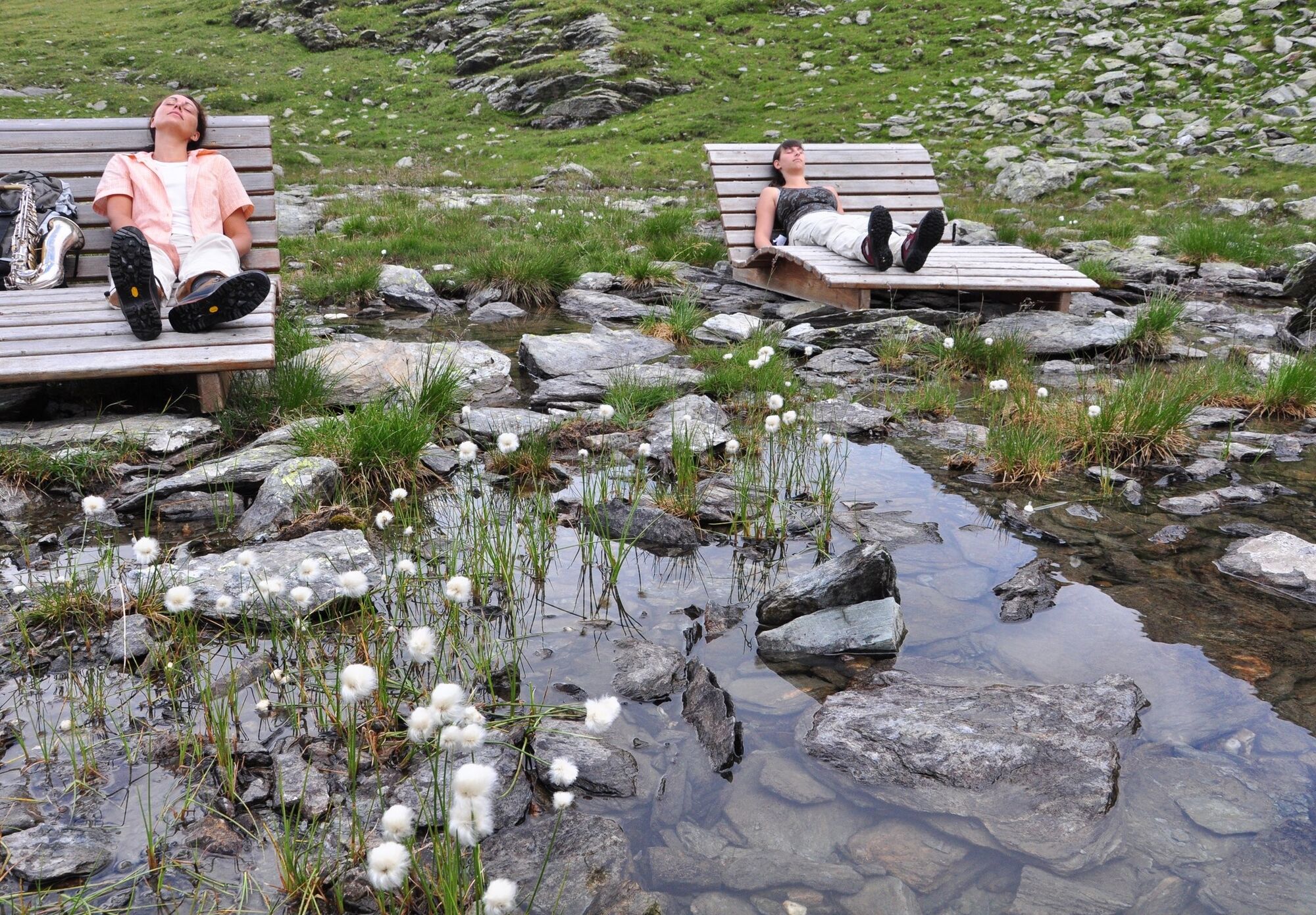
Time out in nature. At Lamnitzsee this slogan becomes reality. Relaxation loungers at the small mountain lake at 2,200 meters above sea level allow the hiker to relax in the sunlit basin below Dachskofel....
Time out in nature. At Lamnitzsee this slogan becomes reality. Relaxation loungers at the small mountain lake at 2,200 meters above sea level allow the hiker to relax in the sunlit basin below Dachskofel. Nearby brooks murmur softly, otherwise there is silence. The path to it leads over flower-rich alpine meadows and high alpine pastures. On the descent to the Unteralm Hut, cairns and animal sculptures accompany the hiker. Time out in nature means enjoying the splendour of nature.
Directly from the parking lot at Leppner Alm, signs show the way towards Scharnik. Through sparse forest, you climb past the Ochsner Hut up to the weather cross. Here keep left, following the sign "Lamnitzsee." The trail ascends to the distinctive grassy ridge. While the route to Scharnik soon leads right uphill over the grassy ridge, you take the other, left route. Once the pasture fence is crossed, you walk on the marked path – without significant altitude gain – in a northern direction. You reach a cirque covered with block fields, always following the signs "Lamnitzsee," and finally arrive at the notch between Dachskofel (2,373m) and Torwand (2,562m) (walking time from the car: about 2.5 to 3 hours). The snowy and icy world of the Hohe Tauern with its highest giant, the Grossglockner, suddenly appears before the viewer.
On the descent from the notch, you soon reach Lamnitzsee (2,293m), where two large wooden sun loungers on the shore wait for the tired hiker. Back on the trail, you walk around Dachskofel downhill until you meet the trail coming from the Hugo Gerbers Hut. You follow this downhill and follow the sign "Unteralmhütte – 15 min" (place to stop). Before the enclosure of the hut, turn left (sign "Leppner Alm"). In the area between forest and alpine terrain, you now follow a small path. Across the Weneberger Alm and other partly damp alpine meadows, you walk back in the direction of Leppner Alm.
Good footwear and sun protection required.
Good footwear and sun protection required.
Via the B100 to Irschen (between Dellach and Oberdrauburg). From here follow the signs "Leppner Alm." Access is also possible and signposted via L15 (from Potschling).
Leppner Alm
From the cirque south of Dachskofel (block fields) you can also reach the Unteralm Hut on a direct trail. Take plenty of time for the relaxing break on the loungers at Lamnitzsee!
Popularne wycieczki w okolicy
-
5,0
Ederplan round from the parking lot Stronach
średniWędrówka 7,19 km -
4,8
Pirknerklamm (C)
średniVia ferrata 2 km -
4,7
Drau Cycle Path R1
światłoJazda na rowerze 75,9 km -
4,0
Emberger Alm - Hochtristen
średniWędrówka 9,50 km -
3,9
Summit hike to the Hochstadel
średniWędrówka 7,83 km -
4,2
The Glockner cycle route R8
średniJazda na rowerze 89,7 km -
4,3
WW_N18 flower paradise Mussen
średniWędrówka 6,52 km -
4,7
Tolzer - Gaugen , Kärnten
ciężkiWycieczki górskie 7,40 km -
5,0
Water Experience Trail Greifenburg
średniWędrówka 7,42 km -
3,3
Kreuzeck High Trail
ciężkidługodystansowy szlak pieszy 52,7 km
Wędrówki i tropienie


Nie przegap ofert i inspiracji na następne wakacje
Twój adres e-mail została dodana do listy mailingowej.