







Tour d'Ambin: Stage 1 San Colombano - Rifugio Ambin (France)
From the hamlet of San Colombano of Exilles, follow a section of the Sentiero Balcone taking trail 814 to Grange della Valle; from the car park in Grange della Valle (road closed bya bar) start the trail...
From the hamlet of San Colombano of Exilles, follow a section of the Sentiero Balcone taking trail 814 to Grange della Valle; from the car park in Grange della Valle (road closed bya bar) start the trail which goes up the valley of Galambra; go up on narrow hairpin bends passing close to a fountain, and reach Colle dAmbin (2897 m). Pay attention to the presence of sections equipped with fixed safety rope (no harness is required). The W. Blais bivouac (2922 m) is close to the colle. The descent into the dAmbin valley starts here. The trail (marked with small piles of stones) first goes along the lake and then continues along the torrent. Close to the intersection with the trail that comes from Colle dellAgnello the track becomes more evident until it reaches the dAmbin refuge (2270 m).

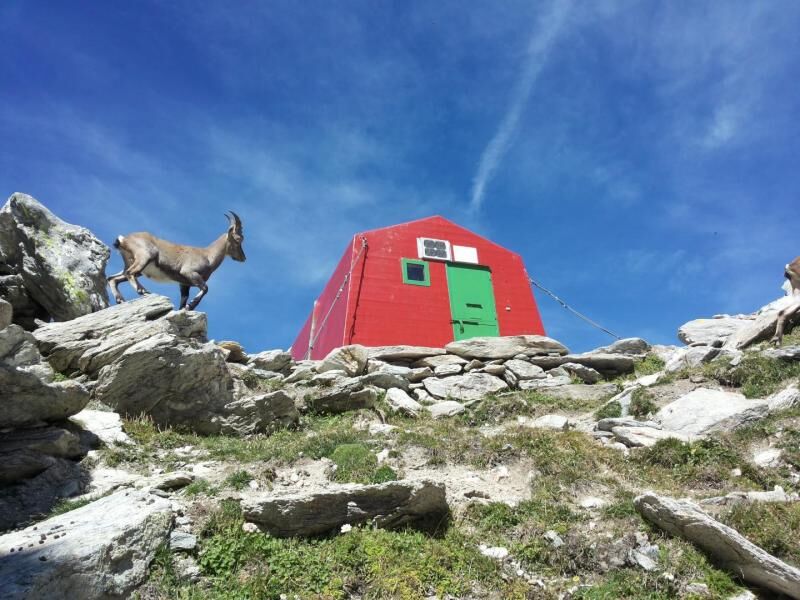

Vom Ortsteil San Colombano in der Gemeinde Exilles folgt man einem Teilstück des Sentiero Balcone (Balkonweg), indem man den Weg 814 nach Grange della Wengen nimmt; vom Parkplatz in Grange della Wengen (Straße mit Schranke gesperrt) beginnt der Weg im Galambra-Tal; er steigt in engen Kehren an, führt an einem Brunnen vorbei und erreicht den Pichl d'Ambin (2897 m). Achten Sie auf die Abschnitte, die mit einem festen Sicherungsseil ausgestattet sind (kein Klettergurt erforderlich). In der Nähe des Pichls befindet sich das Biwak von W. Blais (2922 m). Von hier aus beginnt der Abstieg ins Ambin-Tal. Der Weg (mit Steinmännchen markiert) führt zunächst am See vorbei und dann weiter entlang des Baches. In der Nähe der Kreuzung mit dem Weg, der vom Pichl dell'Agnello kommt, wird der Weg deutlicher, bis er die Ambin-Hütte (2270 m) erreicht.
Da die Route in einer verschneiten Hochgebirgsumgebung verläuft, wird die Verwendung von Trekkingstiefeln, Fleece, Hosen und einer Windjacke aus technischem Gewebe empfohlen.
Hoher Zahn für erfahrene Wanderer.
Vom Zahnkofel, SS24 bis Località San Colombano (Etappe 2 des Balkonwegs) oder Grange della Wengen
Etappenziel San Colombano Biwak W. Blais Refuge d'Ambin (Bramans), Frankreich
Popularne wycieczki w okolicy
-
5,0
BARDONECCHIA Colle Sommeiller
średniMountainbike 25,4 km -
5,0
BARDONECCHIA Forte Jafferau Loop
ciężkiMountainbike 36,8 km -
5,0
BARDONECCHIA Decauville
średniWędrówka 7,29 km -
BARDONECCHIA Monte Jafferau
ciężkiWędrówka 11,6 km -
BARDONECCHIA Rochemolles Dam - Scarfiotti Refuge
średniWędrówka 7,77 km -
4,0
BARDONECCHIA Sentiero dei Cosetti by Luciano Ferraris
światłoWędrówka 3,24 km -
OULX Borgata Seu (Gran Bosco Natural Park)
światłoRakieta do chodzenia po śniegu 5,93 km -
SAUZE D'OULX Richardette - Montagne Seu )
średniMountainbike 19,9 km -
BARDONECCHIA Frejusia Basins - Decauville - Rochemolles Dam
światłoMountainbike 7,54 km -
5,0
BARDONECCHIA Decauville
światłoRakieta do chodzenia po śniegu 4,11 km
Wędrówki i tropienie


Nie przegap ofert i inspiracji na następne wakacje
Twój adres e-mail została dodana do listy mailingowej.





