






Historic Mountain Routes | Frais - Arguel Gran Serin
This route was the main route for the troops who had to reach the Gran Serin batteries, built in 1897 and equipped at the time with 8 cannons and 6 mortars. The dirt road begins today at the Valeis locality,...
This route was the main route for the troops who had to reach the Gran Serin batteries, built in 1897 and equipped at the time with 8 cannons and 6 mortars. The dirt road begins today at the Valeis locality, with a ban on the circulation of motor vehicles at the entrance to the Cottian Alps Protected Areas Park, just beyond Alpe Arguel up to Colle dell'Assietta with which it joins creating a single system road together with the Colle Finestre-Assietta-Sestriere road.

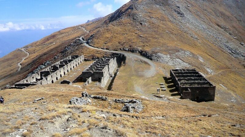

The itinerary starts from the Frais ski resort and then reaches, using a former military road with an almost always steep gradient, the ridge that separates the Susa valley from the Chisone valley. From the crossroads near the church (0 km), proceed left along Via Arguel. After a hairpin bend, near which the asphalt ends, you arrive at the crossroads with via Gran Serin where you continue to the right (0.57), with a long half-coast. At Km 1.48 pay attention to leave the road to the Berg on the left. Soubeirand (no indication). You then pass the huts and the small church of Alpe d'Arguel (4.98) and then reach the two buildings of the modern mountain pasture (5.24). The larch forest crossed so far now gradually gives way to large prairies. The panorama is very beautiful with a view of the Galambra valley, the Quattro Denti peak, the lower Cenischia valley. After passing a barrier, you face the hairpin bends that develop along the border of the Gran Bosco Natural Park, reaching the basin that hosts Lago Grande (9.16). One last effort and here you come across the old road that connected Colle delle Finestre with Assietta (9.63), used before the one at a lower altitude and parallel to the previous one was built, on the Chisone valley side. In short you reach the ruins of the large defensive barracks of Gran Serin (9.79), built between 1884 and 1888 and capable of hosting up to 600 men. A wide and deep moat protected it on three sides while inside two large buildings can be recognized, separated by a large courtyard: one was intended to house the troops while the other, formed by a central body on two floors like the previous one but with two lateral appendages to just one, it was instead reserved for the officers and the service rooms including a large 100,000 liter water tank! In front of the barracks there is a building erected at the beginning of the twentieth century which served as a stable and warehouse. You return to Frais along the same path of the first leg.
Tak
The large defensive barracks of Gran Serin could accommodate up to 600 men. A wide and deep moat protected it on three sides while inside there are two large buildings separated by a large courtyard: one was intended to house the troops while the other, formed by a central body on two floors like the previous one but with two side annexes and service rooms including a large 100,000 liter water tank! In front of the barracks there is a building erected at the beginning of the twentieth century which served as a stable and warehouse. The Gran Serin battery develops in length at 2,600 meters above sea level with artillery emplacements, barracks including stables and a powder magazine, all protected by a long wall. The position covered with its range from the top of Assietta to Monte Gran Costa, covering the Galambra valley, the Niblè, the Quattro Denti peak and the lower Cenischia valley. To date, the structure is in ruins and part of the wall is missing.

Popularne wycieczki w okolicy
-
4,7
Rocciamelone partedjo dalla Riposa. Mompantero, Piemont/Italien
średniWędrówka 10,6 km -
OULX Borgata Seu (Gran Bosco Natural Park)
światłoRakieta do chodzenia po śniegu 5,93 km -
SAUZE D'OULX Richardette - Montagne Seu )
średniMountainbike 19,9 km -
PRAGELATO Colle dell'Assietta
ciężkiMountainbike 53,3 km -
La Via dei Saraceni (Sauze d'Oulx)
średniMountainbike 33,6 km -
PRAGELATO The winter charm of the Val Troncea Natural Park
światłoRakieta do chodzenia po śniegu 4,62 km -
The Glorious Return of the Waldensians | Stage 3 Arlaud Refuge - Granges
średniTrasa pielgrzymki 16,4 km -
FENESTRELLE MTB to Selleries Refuge
średniJazda na rowerze 16,0 km -
5,0
Cima Quattro Denti (from Grange della Valle)
średniWędrówka 5,30 km -
PRAGELATO Val Troncea: the valley of flowers
średniWędrówka 8,36 km
Wędrówki i tropienie


Nie przegap ofert i inspiracji na następne wakacje
Twój adres e-mail została dodana do listy mailingowej.





