


Piemonte without a car | Pont Canavese-Lanzo Stage 1: Pont Canavese-Rifugio Alpe Soglia
Poziom trudności: T2
Pont Canavese is the natural meeting point and connection between the Orco and Soana Valleys that fork just above the town, the gateway to the Canavese side of the Gran Paradiso National Park. Due to its...
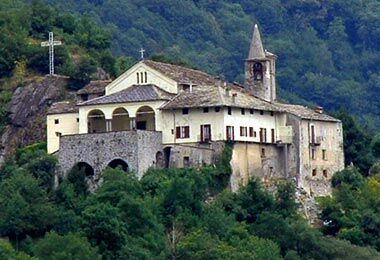
The historic center can be reached via the ancient Via del Commercio, a porticoed street, now Via Caviglione, is a suggestive route that leads to the heart of the historic center where the Church of Santa Maria in Doblazio is located, despite the renovations the oldest of all the churches in the Orco and Soana valleys, with two bell towers, of which the round one was a watchtower from the 11th century. Also notable is the Church of San Costanzo, from the 14th century.
"La Balma" is a glacial erratic boulder, in the Sarro area, on the old road to Sparone and has hosted a real home since at least the 18th century, even if legend has it that it was used by King Arduino for his soldiers. The surface of the rock is entirely covered by a vine; a staircase built with dry stone walls climbs up the boulder to the top and the interior preserves a large fireplace carved into the stone, some partitions, a large press and a vat.
Alpette (957 m.) is a small village surrounded by chestnut and birch trees, located on a grassy plateau with a wonderful view of the mountains, from the Orco Valley to the Gran Paradiso Massif. Until the mid-16th century it depended on Pont and in 1773 it obtained autonomy, redeeming a large sum that Pont had already given to the Duchy a century earlier to block its secession. But only in 1889 was the carriage road built, crossing the historic mule tracks, later modernized in the 1960s. The church of San Pietro e Paolo from 1864 is a remodeling of previous buildings on an 11th-century base and has frescoes dating back to 1514. Another religious building, that of San Rocco from the 16th century. Above the town hall was built the Don Giuseppe Capace astronomical observatory, the second most important in Piedmont, with a dome of 5.5 meters in circumference.
The Ecomuseum of copper, work and Resistance houses over 800 pieces of copper craftsmanship: the extraction and processing of the metal dates back to ancient times. The "magnin" of Alpette were considered among the best craftsmen of hand hammering, a process with which objects for everyday life were made, especially pots. With the start of industrialization, at the beginning of the 20th century, for their skill they were called by the automobile industry to work as "panel beaters" in car bodywork.

The itinerary continues along the ring road, on the asphalt road (Via Ceritti): at the height of a small house with an orange façade, on the left there is the signpost for trail 501/AVC/SR (Sentieri Resistenti), a sign indicating the locality of Musrai: here the path starts climbing into the beech forest, passing the clearing of the Masonetto huts; at the crossroads with a dirt road, keep left until you reach the small votive chapel that offers a panoramic view of the Nero hamlet, Mount Calmia to the east and the plain below.
From here, slightly downhill, past a small stream, you climb to the panoramic hamlet of Musrai (1,128 m), a plateau with some renovated houses and the characteristic two-storey church, with three votive frescoes, an alpine pasture and a hut / refuge with an adjoining particular “stilt house” with a transparent roof. Continue along the dirt road that reaches the hamlet for about 300 meters, then take the path, turning sharply to the right, that, after passing a hydraulic intake, climbs into the beech forest, until reaching the Piazzale della Balmassa 1,300 m., where the road ends. Continue on the rather bumpy track following the signs until reaching the Bassa di Mares pass, 1,490 m, in the territory of Canischio in the underlying Gallenca Valley. From the pass, the - half-coast path, signpost 456A/AVC/SR - reaches Cima Mares (1,654 m.). The peak, identified by a high cross and a large "little man" of stones, despite the low elevation, is a panoramic point on the Canavese plain, the mountains of the Orco and Soana Valleys and on the Serra Morenica ranging from the Graian Alps to the Maritime Alps.
In the opposite valley we see the Sparone mountain pastures. From here the ridge path – signpost 456/AVC - leads with slight ups and downs to cross the Canischio mountain pasture track that passes by the white Chapel of San Bernardo di Mares (1,543 m), a structure that also serves as a bivouac. The path continues slightly uphill, under the ridge line, on the Val Gallenca side up to Colle della Pessa (1,621 m) where orographically it passes onto the Valle Orco side, and from here it continues to climb until it passes between the two large structures of Alpe del Calus (1,788 m).
The track continues to climb towards the south west on the path between grassy carpet and outcropping spikes up to the tip of Monte Soglio (1,971 m). On the small square at the top there is a cast statue of the Madonna, placed on a small pyramid, a commemorative pillar and an orientation table placed by the CAI on a concrete cylinder. Its strategic position makes it, on clear days, a 360° panoramic point that ranges from the Alps to the plain.
From the summit you quickly descend to Alpe Rossolo (1,935 m.) and from here, following the 416 signpost with descent, it is fast and in a few minutes you arrive at the Alpe Soglia Refuge at an altitude of 1,723 m., built on a panoramic balcony just below the crest that connects Monte Soglio with Uja di Corio, in the territory of Corio, from which it can be reached by a dirt road from the Vallone di Piano Audi.
Tak
www.trenitalia.com
www.extrato.it
T2
Pont Canavese, the historic center and the sanctuary of Santa Maria in Doblazio
Alpette (with the Copper Ecomuseum and Astronomical Observatory)
Borgata Musrai
San Bernardo di Mares
Cima Mares
Monte Soglio
Rifugio Alpe Soglio
Popularne wycieczki w okolicy
ALPETTE Monte Soglio and cima Mares from Balmassa
średniWędrówka 10,9 kmBALDISSERO CANAVESE The Monti Pelati nature reserve
średniWędrówka 7,19 km- 5,0
ROCCA CANAVESE Madonna della Neve - Bandito Chapel
średniWędrówka 12,4 km - 4,0
VALPERGA Sacro Monte di Belmonte Loop
średniWędrówka 10,3 km COLLERETTO CASTELNUOVO Pian del Lupo - Quinseina di Santa Elisabetta
ciężkiWędrówka 6,27 kmLANZO TORINESE Mulino Turcin loop
średniWędrówka 10,3 kmSPARONE The ancient mule track of Frachiamo and the Rocca di Sparone
średniWędrówka 6,17 kmPunta Arbella from Campidaglio
średniWędrówka 6,29 kmCANTOIRA Loop of the alpine villages
średniWędrówka 6,79 kmLake Pratofiorito from Porcili
średniRakieta do chodzenia po śniegu 11,9 km
Wędrówki i tropienie


Nie przegap ofert i inspiracji na następne wakacje
Twój adres e-mail została dodana do listy mailingowej.