


Piemonte without a car | Between Pian dell'Orso and Sacra di San Michele
The starting point of the itinerary, near Villar Focchiardo, can be reached on foot from the Borgone Susa train station. You go up the mountain side, crossing thick and precious chestnut groves (the famous...
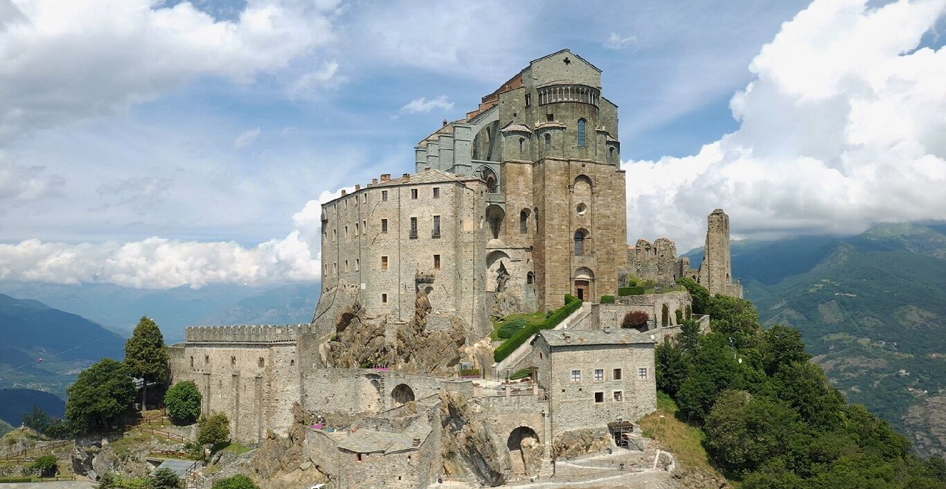
Continuing you reach Colle Bione with another mountain chapel and nearby a memorial stone that commemorates the Fallen partisans of the War of Liberation. Finally the descent ends at the Sacra di San Michele and via the mule track to S. Ambrogio, where you can take the train back.

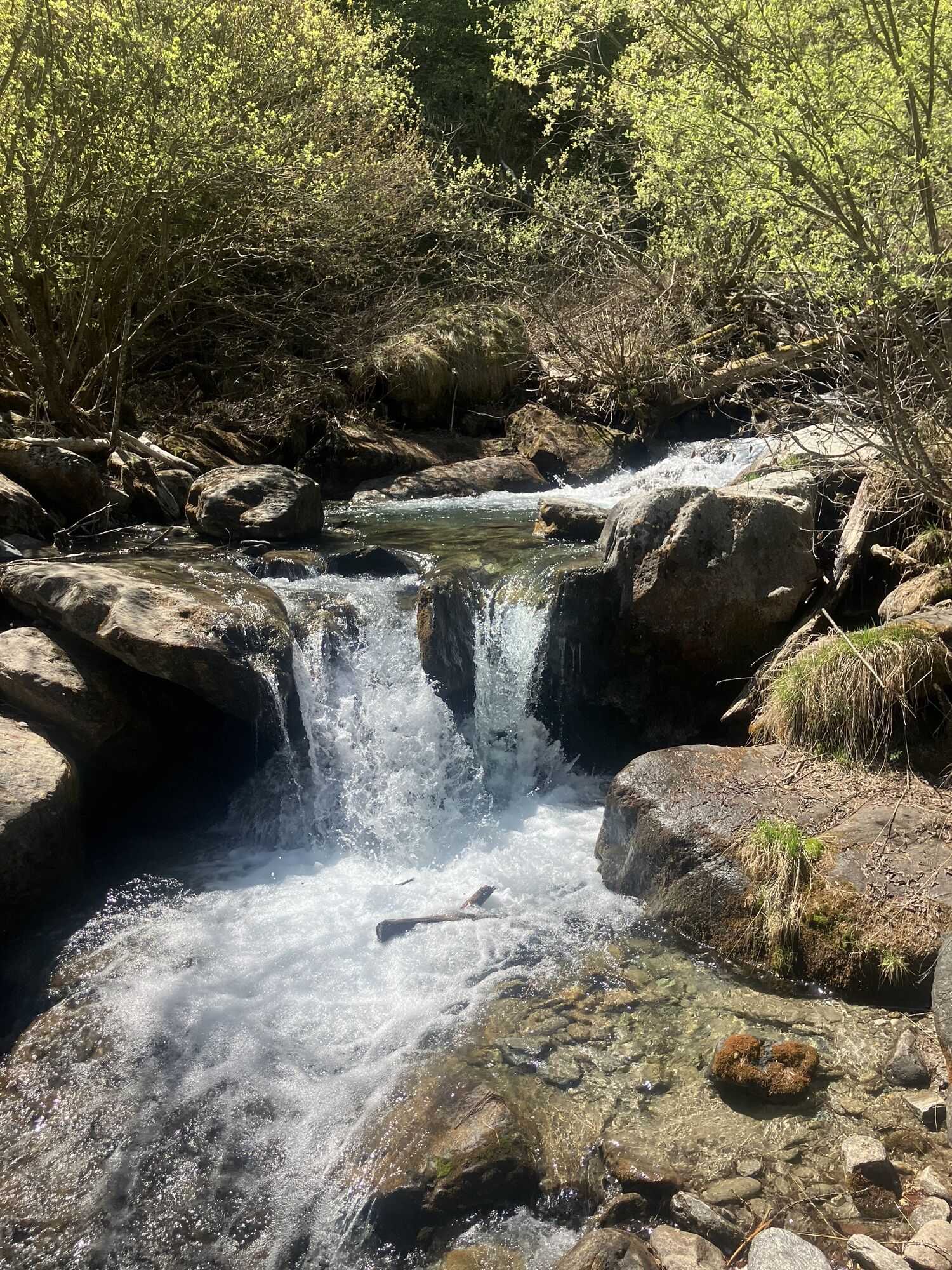
Starting from Borgone station, you reach the bridge and cross the Dora. You then pass through Borgata Giaconera di Villarfocchiardo heading towards the town centre. You then follow the signs towards the Certosa di Montebenedetto along the asphalt road that passes through small hamlets. From the first bend you come across signs (old wooden signs that are rather damaged) for the Certosa and the Ceat Gravio refuge on route 506. You touch the hamlets of Castellaro and Mongirado inferiore and superiore with the mule track that cuts across the bends in the road. At about 960 metres above sea level, at a bend, you leave the road for a final stretch that diagonally follows the Molesecco stream to the Certosa. From here, you continue on 506 with the path that stays on a ridge on the right bank of the Rio Gravio until you reach a crossroads. Take the short link road on the right, crossing the Rio and quickly reaching the refuge. From the refuge, cross the Gravio stream and go up to the intersection with path 506. Continue on path 522 with slight ups and downs until you reach the Piansignore mountain pastures (1482 m). After a short downhill stretch, you will find a signpost that still leads you along a path halfway up the hill until you reach the Fumavecchia mountain pasture (1421 m) and Fontana del Vallone (1450 m), where you will find the intersection with path 524. The path remains flat for a few hundred metres and then begins to climb more steeply among the silver firs and larches. On the path, you will find a sign for Cà ‘d Marc "Picapera": a shelter under the rocks inhabited, in the second half of the 19th century, by a shepherd who carved writings and silhouettes of men and animals on the surrounding rocks. Continuing, the larches thin out and you arrive at the Pian dell’Orso chapel at 1850 m. You cross the plain in the direction of the pass that marks the watershed with the Sangone valley. Once past the pass, turn left (east) and continue on path 435 in the direction of Colle Bione. For this entire long stretch, the path stays on the southern side of the ridge, alternating moderate descents and flat sections. Once past the Colle Bione chapel at 1430 m, the very busy path stays on the ridge until Roccia Corba at 1480 m and from there it descends sharply to Tre Roc. From here, you continue along the ridge, touching Colle del Termine and Colle della Bera, and then begin to descend towards Prese di Gianot and Colle Braida (1006 m). A short stretch in the woods allows you to reach the hamlet of Basinatto, from where the road continues downhill until a steep shortcut on the left that allows you to cut a wide loop of the road. In this way you arrive at the Croce Nera square (861 m) from where you can reach La Sacra di San Michele and then descend to Sant'Ambrogio through the San Pietro hamlet (path 502).
The starting point of Villarfocchiardo can be reached on foot from Borgone Susa, served by the SFM3 Torino Porta Nuova-Susa railway line. For the return to Turin, refer to the Sant'Ambrogio di Torino railway station on the same line. www.trenitalia.com
Historic center of Villar Focchiardo with the parish church of Maria Vergine Assunta
Certosa di Montebendetto
Mountain chapels of Pian dell'Orso and Colle Bione
Sacra di San Michele
Historic center of Sant'Ambrogio and Via ferrata "Carlo Giorda"
Popularne wycieczki w okolicy
Avigliana Lakes - Easy route, ideal for families with children
światłoWędrówka 9,25 km- 5,0
Unspoiled woods and ancient hamlets in Valsangone - Selvaggio Loop - Bagaggera
światłoWędrówka 9,08 km COLLE DEL LYS Monte Arpone loop
światłoWędrówka 4,50 kmEasy route - Monte Cuneo (Moncuni) Loop route from Reano
światłoWędrówka 7,97 km- 4,0
The Giro dell'Orsiera G.O. Trail Stage 1: Molè - Rifugio Balma
średniWędrówka 4,52 km - 4,0
ROURE by MTB at Prato del Colle
średniJazda na rowerze 7,82 km COLLE DEL LYS Alpine Loop
średniWędrówka 15,3 kmLe Strade dei Forti - stage 6 from Perosa Argentina to Fenestrelle
średniTrasa pielgrzymki 19,4 kmPINEROLO Trail "Ecomuseum of the Charcoal Piles"
średniWędrówka 7,46 kmFrom Giaveno to Colletto del Forno by MTB
średniMountainbike 19,8 km

Wędrówki i tropienie


Nie przegap ofert i inspiracji na następne wakacje
Twój adres e-mail została dodana do listy mailingowej.