


Going-Within-Yourself-Path Sirnitz
From the parking lot of the Albeck municipal office you go to the meditation path "Going within yourself." This 2 km-long side path of the Hemma pilgrimage route runs along the romantic Rammelbach and...
From the parking lot of the Albeck municipal office you go to the meditation path "Going within yourself." This 2 km-long side path of the Hemma pilgrimage route runs along the romantic Rammelbach and with nine stations invites you on a journey to ourselves – a perception with all senses. The stations Water Portal, Tree Meditation, Contemporary Witness, Waterpower, Water Trough, Barefoot Path, Balls, Old Mill, and Water March make the meditation path a unique experience and offer an excellent opportunity to take a break and fully enjoy the beauty of nature.
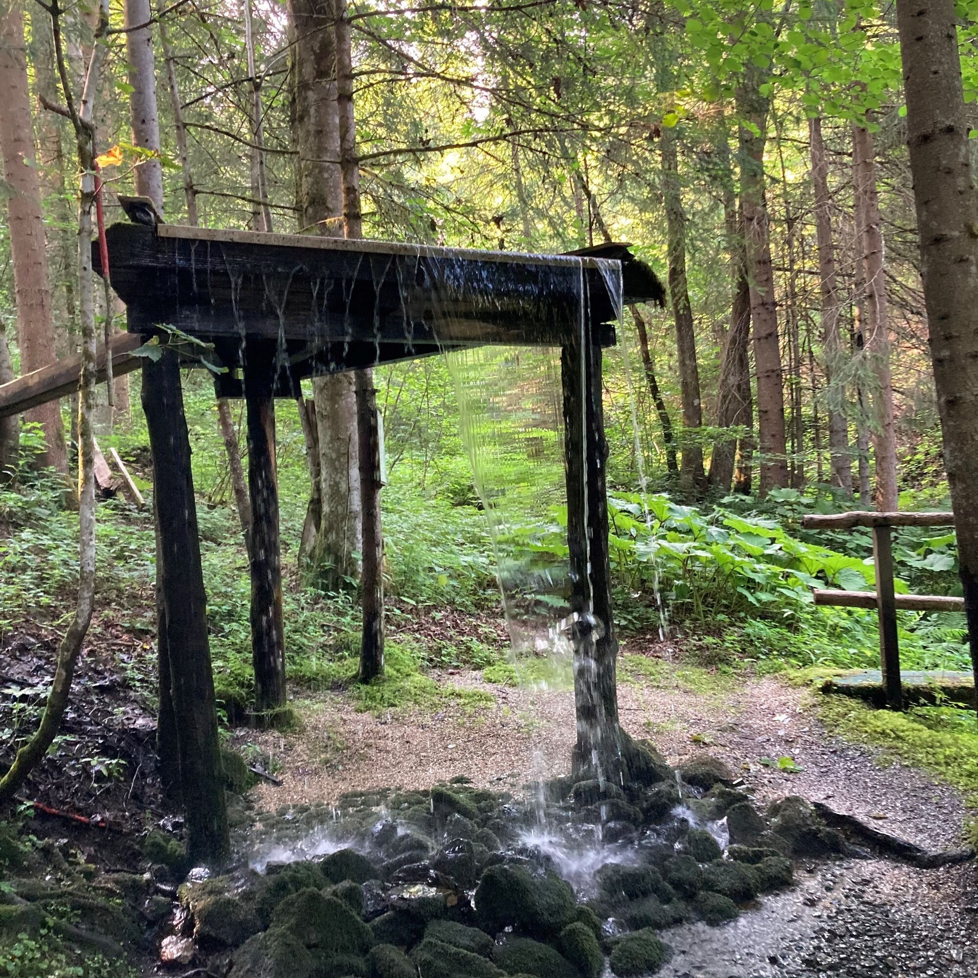
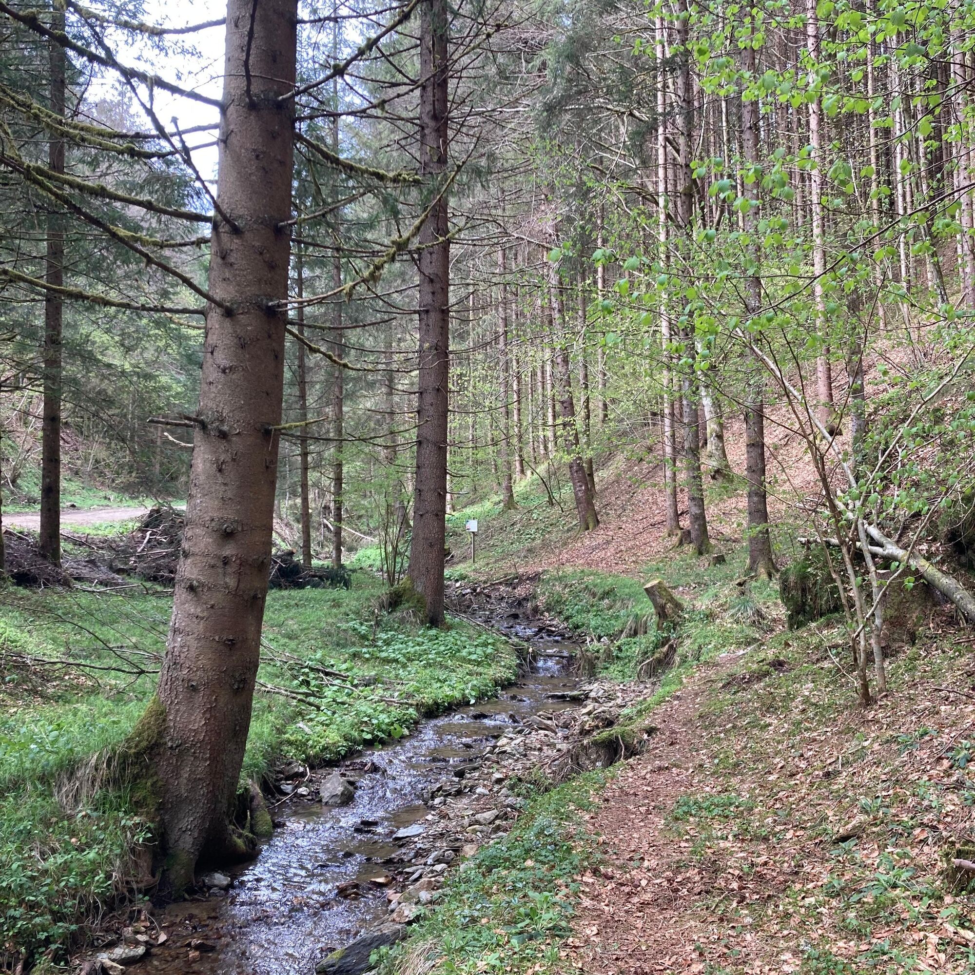
The parking lot at the Albeck municipal office offers a perfect parking opportunity as well as an ideal starting point for the journey. From the municipal office, walk past the wayside shrine about 50 meters to the turning to Platzerweg on the right side. From the turning, go straight ahead to Platzergraben and thus also to the first station. On the right side, there is a small bridge to reach the stations. At the "Waterpower" station, cross the stream again and continue on the forest path until you reach the connection to the next stations. The last station is the Water Portal, which can be reached by a staircase on the right side of the path. The return route runs along the forest path.
Tak
Tak
Important prerequisites for the success of a mountain route are, in addition to the careful study of guides and maps, optimal equipment.
The basic equipment includes:
solid, well-fitting mountain or hiking boots with a grippy sole
water- and wind-repellent mountain clothing in layers, hiking poles
sunglasses, sun protection
mobile phone and hiking map
a first aid kit
as well as enough to drink and a snack
Proper behavior in the mountains
Careful route planning based on descriptions and hiking maps is indispensable for the success of a mountain hike.
It is equally important to correctly assess the mountain experience, fitness, surefootedness, freedom from dizziness and resilience of all participants.
Never leave marked hiking trails and avoid shortcuts.
Inform yourself about the weather conditions before the hike and return to the valley in case of worsening weather.
The mountains are for everyone. Helping to maintain and keep them clean is the duty of every hiker. Take your rubbish down to the valley and protect the animal and plant world.
Always keep dogs under control and on a short leash. If an attack by a grazing animal is to be expected, immediately unleash the dog.
Austrian farmers make an important contribution to preserving our alpine landscape. Visitors are asked to adapt respectfully to this beautiful landscape.
Show respect to the people working here, nature and the animals.
Here are the most important emergency numbers in case of an accident in Austria:
140 Alpine Emergency
144 Emergency rescue
112 European emergency (accessible from all networks. Turn off mobile phone and after turning it on, instead of the PIN, dial the number "112".)
Feldkirchen - Sirnitz
Ebene Reichenau - Hochrindl - Sirnitz
Althofen - Straßburg - Gurk - Weitensfeld - Sirnitz
By bus 5208 from the bus station in Feldkirchen to the Sirnitz Mitte stop
Parking lot at the Albeck municipal office
Further information about the hiking area of the region is available at:
Region Millstätter See - Bad Kleinkirchheim - Nockberge
+43 (0) 4246-37444
info@mbn-tourismus.at
www.seeundberg.at/wandern
The UNESCO Biosphere Park Nockberge
Imposing, mighty and unique – the UNESCO Biosphere Park Kärntner Nockberge is an alpine jewel with unique natural treasures, a diverse cultural landscape as well as rare animal and plant species. For centuries, people have lived here in harmony with nature. Gently rolling with peaks over 2400 meters and picturesque alpine meadows – the Biosphere Park Kärntner Nockberge is a rare natural idyll in the midst of the Austrian Alps and covers an area of about 500 square kilometers.
In 2012 it was designated a biosphere park by UNESCO. The park is based on the three pillars of sustainability: ecological balance, economic security, and social justice. Here, people live in harmony with nature and respect and cherish the rare animal and plant world.
Regional products, processed according to old traditions, testify to careful work following traditional recipes. Trained biosphere park rangers promise unforgettable tours for families, and in several educational programs, this knowledge is also passed on to pupils. Regardless of the season, the biosphere park always offers a treasure chest of experiences.
Further information about the UNESCO Biosphere Park Kärntner Nockberge is available at: www.biosphärenparknockberge.at
Taking a minute for yourself and enjoying the peace is inevitable.
Popularne wycieczki w okolicy
- 4,1
Slow Trail Bleistätter Moor (Variant A)
światłoWędrówka 7,22 km - 4,6
Hochrindl - Lattersteighöhe
średniWędrówka 9,17 km - 4,6
Hochrindl-weises Kreuz
średniWędrówka 12,4 km - 4,8
Kneipp hiking path Flattnitz
światłoWędrówka 9,79 km - 4,9
Slow Trail Maltschacher See - large loop
światłoTrasa tematyczna 7,04 km - 3,5
Flattnitz Haidnerhöhe - Hirnkopf
średniWędrówka 6,93 km - 4,0
Hochrindl - Almhütten-Wanderung (AGW Almgenussweg ) um den Kegel
światłoWędrówka 9,31 km - 4,3
Rundwanderung Hochrindl - Speickkofel - Bretthöhe - Lattersteig
ciężkiWędrówka 20,9 km - 4,8
Almenwasserweg - Flattnitz
światłoWędrówka 6,62 km - 3,9
Natural spectacle Tiebel springs - Himmelberg
Wędrówka 9,84 km
Wędrówki i tropienie


Nie przegap ofert i inspiracji na następne wakacje
Twój adres e-mail została dodana do listy mailingowej.