






Lantschfeld route - start Tweng

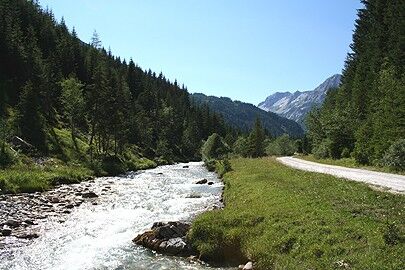

The route leads on gravel forest roads into the tranquil Lantschfeld valley and always runs along the stream of the same name. After about six kilometers, biking is no longer permitted; from here, there is a general driving ban. It is recommended to continue on foot to the farmed cooperative and Müllneralm or extend the route to the Blausee. On the return journey, a stop at the Tennfall should definitely be planned!
Those starting out with a mountain bike in the terrain should be well equipped – for safety, comfort, and riding pleasure.
A helmet is mandatory, gloves and protectors (knees, elbows, back) offer additional protection. Breathable clothing, padded cycling shorts, and sturdy shoes ensure comfort – ideal in all weather with a wind or rain jacket. Don't forget a water bottle or hydration system, as well as a small snack for in between. A first aid kit and a charged mobile phone are also advisable for emergencies.
ARRIVAL BY CAR:
Arrive safely, quickly, and easily at your vacation destination. Tweng is easily accessible via well-developed roads – from all directions!
Access from the north
Motorway Munich - Salzburg - A10 Tauern motorway - Radstadt motorway exit, Exit 63 - B99 Katschberg federal highway - Radstadt - Obertauern - Tweng
Access from the south
Villach - A10 Tauern motorway - motorway exit toll station St. Michael, Exit 104 - Mauterndorf - Tweng
Access from the east
Vienna - A2 - S6 - Semmering - A9 Pyhrn motorway - Liezen B320 - Radstadt or Judenburg - Murtal federal highway - Murau - Tamsweg - Mauterndorf - Tweng
TIP: If you want to arrive by public transport, the postbus line 280 stops directly in Tweng.
Free parking spaces are available at the municipality or at the Twenger Lantscheld parking lot (after the bridge on the right)
Visit the Tennfall! A beautiful waterfall, perfect for a jump into the cool water.
Kamery internetowe z trasy
-
Plattenkar
-
Grünwaldkopf
-
Zehnerkar
-
Sporthotel Snowwhite
-
Hotel Cinderella
-
Sonnenterasse Edelweissalm
-
Hotel Garni Gloria
-
Lürzeralm
-
Hotel Kesselspitze
-
Hotel Schneider
-
Breitlehenalm
-
Gamsleiten
-
Obertauern - Haus Petergstamm
-
Schaidberg
-
Zehnerkar
-
Obertauern - Aparthotel Weninger Alm
-
Obertauern - Gamsleiten
-
Hotel “Der Sailer”
-
Gamsleiten
Uzyskaj wgląd
Zawsze na żywo z ponad 9 500 kamer internetowych. bergfex Jako użytkownik Pro, możesz teraz zobaczyć odpowiednie kamery internetowe dla wielu wycieczek w aplikacji wycieczki od. Pozwala to na bezpośredni podgląd aktualnych warunków.
Popularne wycieczki w okolicy
-
5,0
Hüttschlag: Karteistörl - Tappenkarsee - Draugsteintörl - Draugsteinalmen
średniWędrówka 13,5 km -
4,9
Rundwanderweg von der Fallhausalm und Vögeialm übers Klamml zur Oberhütte am See
średniWędrówka 10 km -
4,2
Tappenkarsee Kleinarl
średniWędrówka 9,11 km -
4,6
Ski route Lackenkogel
średniWycieczka narciarska 7,82 km -
4,8
Obertauern to the Johannes Waterfall
średniWędrówka 9,39 km -
5,0
4-Gipfel-Tour
średniWycieczki górskie 6,40 km -
5,0
Twengsee
średniWędrówka 9,66 km -
4,8
Steirische und Lungauer Kalkspitze über das Kranzl
ciężkiWędrówka 11,2 km -
4,6
Mosermandl Windischscharte, Salzburger Land/Österreich
ciężkiWędrówka 14,6 km -
4,6
Tappenkarseehütte von Schwabalm
światłoWędrówka 5,04 km
Wędrówki i tropienie


Nie przegap ofert i inspiracji na następne wakacje
Twój adres e-mail została dodana do listy mailingowej.





