


Kalkofenrundweg
Japons lies on the edge of the extensive Saaßwald forest. The church and vicarage rise up on the hill and the village nestles around them. The Saaßwald forest and the many well-maintained paths guarantee...
Japons lies on the edge of the extensive Saaßwald forest. The church and vicarage rise up on the hill and the village nestles around them. The Saaßwald forest and the many well-maintained paths guarantee relaxation for body and soul for walkers and cyclists. In the Saaßwald forest, you can also take a break at the "Florianibründl" - a chapel with a spring built by a forester Rondonelli in 1808. Along the Thumeritzbach stream, visitors can enjoy a natural landscape that has been preserved in its ecological form and is also popular for youth camps. Also worth a visit is the "Haidlmühle" on the Thaya with bathing and fishing opportunities. Japons has developed into the region's bioenergy village with the expansion of wind power and a biogas plant.

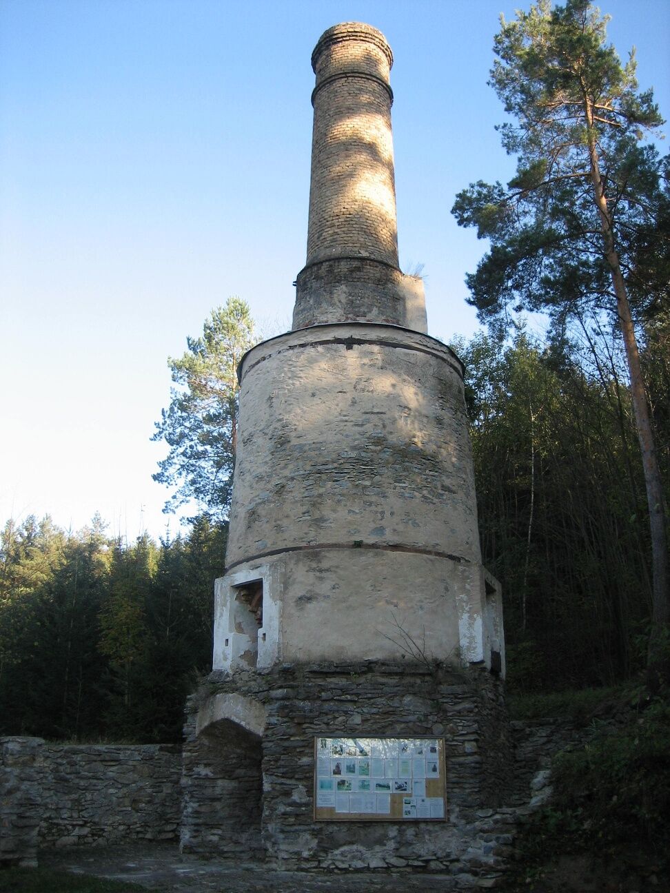
Der Weg führt dich vom Ortsanfang Zettenreith hinauf auf eine kleine Anhöhe, weiters durch einen kleinen Wald zu der Hauptstraße Richtung Zissersdorf. Links davon liegt die Siedlung Phyrahof. Mit diesen so genannten „Aussiedlerhöfen“ wurden die Bewohner des Truppenübungsplatzes Allentsteig 1940 entschädigt. Du überquerst die Straße - geradeaus geht es nun nach Unterthumeritz hinunter und rechts durch den Ort durch. Ein wenig außerhalb Richtung des Ortes am anderen Ufer des Thumeritzbaches an der Straße nach Sieghartsreith steht der Kalkofen. Unterthumeritz war das regionale Zentrum der Kalkproduktion. Der Ofen wurde 1904 mit drei Brennkammern erbaut und gehörte zu den größten dieses Typus in Mitteleuropa. Der Wanderweg führt dich zurück über Oberthumeritz. Fast schon am Ortsende geht es rechst hinauf nach Goslarn. A) Am Ortsende von Goslarn biegst du leicht links in einen Feldweg ein und kommst wieder zurück nach Zettenreith. Anschluss an TTW 633 nach Drosendorf. B) Oder du gehst am Ortsende von Goslarn geradeaus die Straße entlang zum TTW 633 nach Japons.
Wien: A 22 - Stockerau - B4 bis Horn – L 8019 bis Japons
Linz: A 7 Richtung Freistadt - B 310 bis Freistadt - B 38 bis Karlstift - B 41 bis Schrems - B 2 bis ÄGöpfritz an der Wild – L 8038 bis Ellends – L 60 bis zur Kreuzung mit der L 52 Richtung Irnfritz bis Japons
Marktgemeinde Japons
3763 Japons 64
T 02914/62 02, F DW 4
gemeinde@japons.at
www.japons.at
WALDVIERTEL Tourismus
3910 Zwettl, Sparkassenplatz 1/2/2
(T) +43(0)2822/54109, Fax DW 36
Gebührenfrei im Inland:
(T) +43(0)800/300 350
(E) info@waldviertel.at
(I) www.waldviertel.at
Bioenergiedorf Japons - Anmeldung für eine Führung durch die Biogasanlage bzw. fürs Grillen bei Hr. Erich Engelbrecht, T 0664/4530183 oder für eine Führung am Themenweg bei Fr. Anita Steininger, T 02914/6455, E steininger@aon.at
Popularne wycieczki w okolicy
-
5,0
Drosendorf - Gaberbachweg
średniWędrówka 12,6 km -
5,0
Wasser und Felsen
światłoWędrówka 8,31 km -
5,0
Ritterweg Ruine Kollmitz Raabs an der Thaya, Niederösterreich
Wędrówka 12,0 km -
3,0
Thayarunde Waldviertel - 1. Etappe
światłoKolarstwo długodystansowe 20,9 km -
5,0
Fuchsberggraben Runde
średniWędrówka 9,84 km -
5,0
Irnfritz - Steinplattenwald
światłoWędrówka 10,5 km -
5,0
07 Grenzlandweg, 09. Etappe: Geras - Hardegg
światłodługodystansowy szlak pieszy 23,2 km -
5,0
Kollmitzgraben
średniWędrówka 13,4 km -
2,0
Seebsbachrunde
średniJazda na rowerze 28,3 km -
5,0
Pernegger Rundwanderweg
średniWędrówka 13,2 km
Wędrówki i tropienie


Nie przegap ofert i inspiracji na następne wakacje
Twój adres e-mail została dodana do listy mailingowej.