


Kleine Pangratzebenrunde
This short hiking circuit leads from the Lindabrunn sports school (from Lindabrunn along the Talleitengasse) along gravel forest roads through the forest area known as Pangratzeben. At the beginning you...
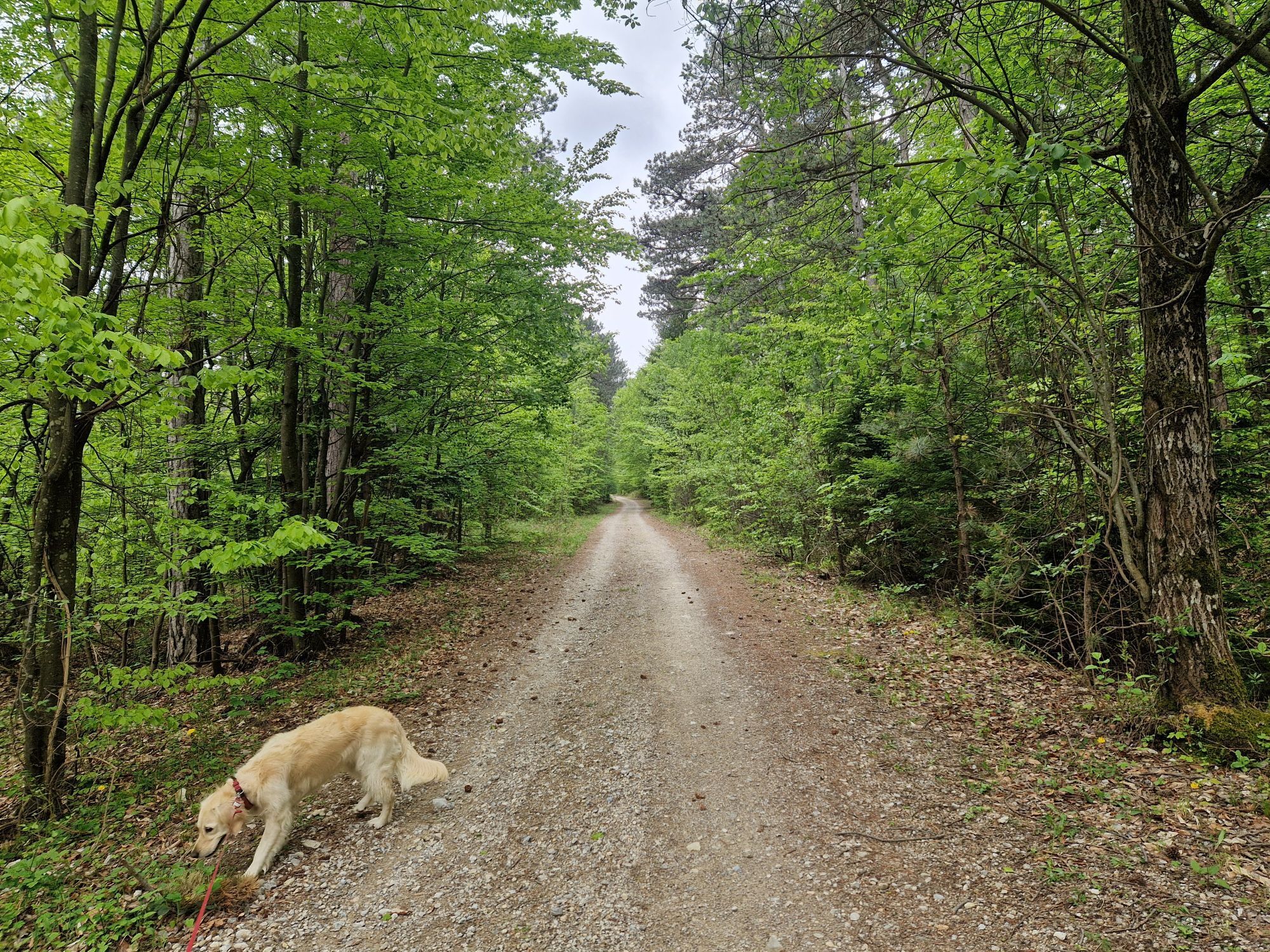
This short hiking circuit leads from the Lindabrunn sports school (from Lindabrunn along the Talleitengasse) along gravel forest roads through the forest area known as Pangratzeben. At the beginning you hike through black pine forests, which occasionally allow a view out into the Vienna Basin. The pine forests then give way to mixed forest and beech forest.
There are also some interesting points to make the hike entertaining: Hubertus Chapel, the twin pine tree natural monument, a small pond, a soldier's grave (in memory of an unknown soldier who died here in the Second World War) and a pine fountain. The route is also suitable for baby carriages. After the hike, you can stop off at Gasthaus Glantschnig, Cafe Zentral or one of the cozy wine taverns in the Lindabrunn district.

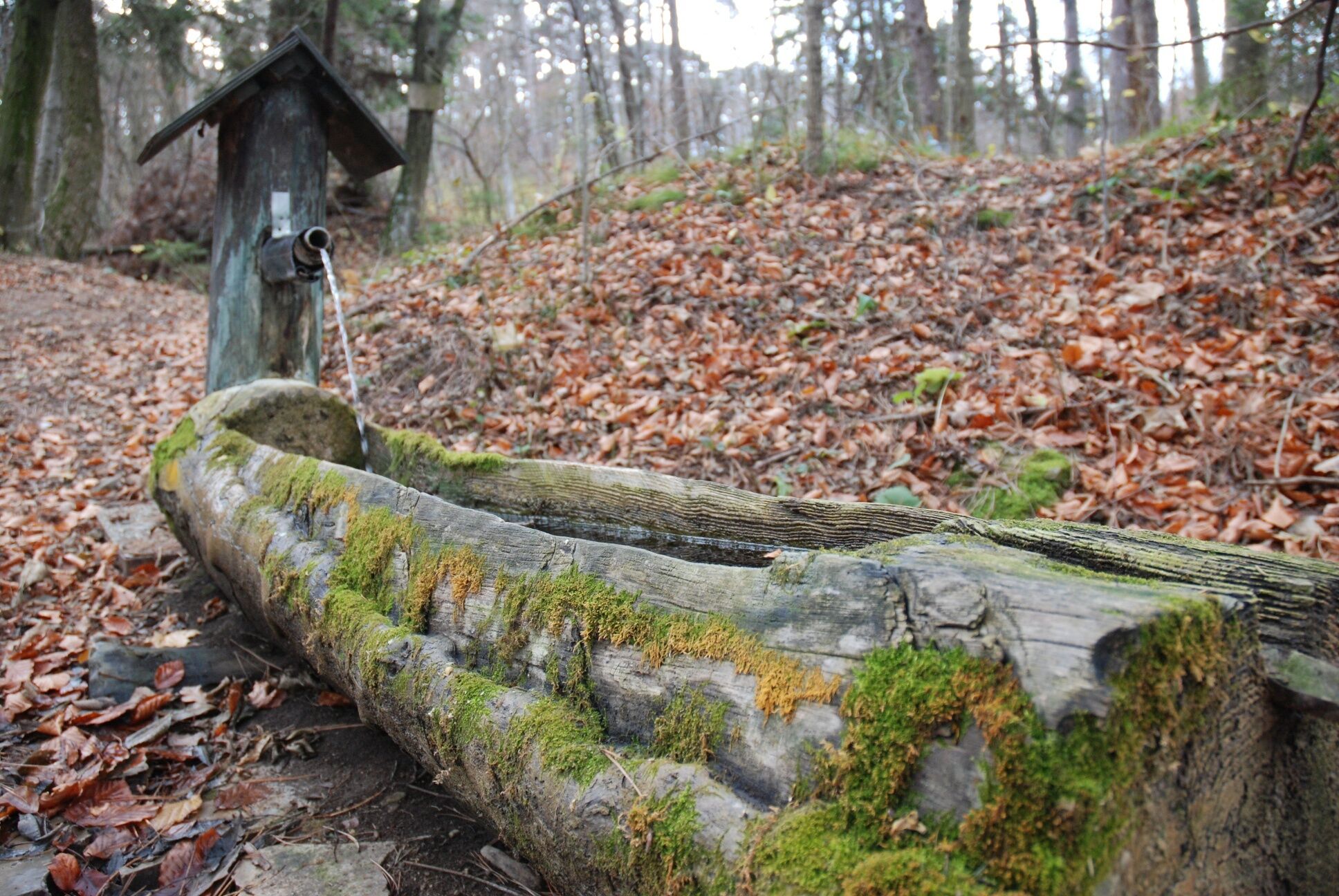
Vom Parkplatz (von Lindabrunn hierher auf der Talleitengasse) der Straße bergauf folgen, diese geht bald in eine schottrige Forststraße über und nach 150 m erreicht man eine Kreuzung. Hier nun rechts auf der Forststraße bergauf (Holzwegweiser des FVV Enzesfeld-Lindabrunn, Routen 3, 4, 5, 6, 7, Schranken) anfangs steiler, dann bald flacher werdend. Nach 500 m wird so auf Höhe 411 m eine Lichtung mit Wiese, Rastplatz, Hubertuskapelle, Teich und Naturdenkmal Zwillingsführe erreicht. Bei der Weggabelung vor der Wiese hält man sich geradeaus (leicht links) und folgt der Forststraße nun 400 m weit steigend bergauf bis ein Flachstück erreicht wird. Hier führt (bei Pkt. 454 m) geradeaus der Wanderweg zum Henninger weiter, man wendet sich aber, dem Verlauf der Forststraße folgend nach rechts und wandert die Forststraße, großteils eben, teilweise leicht fallend und steigend weiter bis eine scharfe Rechtskurve (H = 480 m) und damit der höchste Punkt der Wanderung erreicht ist. Man folgt der Rechtskurve und dem weiteren Verlauf der Forststraße nun bergab. Etwa 800 m nach der Kurve liegt rechts des Weges (ca. 30 m im Wald) das Soldatengrab. Ein Steinmann am Rand der Forststraße markiert diese Stelle. 500 Meter weiter kann man links des Weges (20 m links der Forststraße, H = 420 m) den „Föhrenbrunnen“ besuchen (Brunnen und Rastplatz). Weiter auf der flacher werdenden Forststraße kommt man zurück zur Wiese mit der Hubertuskapelle und nimmt den bereits bekannten Weg zurück zum Ausgangspunkt.
Normale Wanderausrüstung
A2 Südautobahn Abfahrt Leobersdorf, Richtung Enzesfeld, rechts in Fabrikstraße, links über Bahnübergang und der Wiener Neustädterstraße folgen. Rechts abbiegen auf die Hernsteinerstraße und Richtung Lindabrunn und Hernstein bis zur Abzweigung in die Talleitengasse („Sportschule“). Dieser Gasse bis zur Sportschule Lindabrunn folgen und gleich danach parken.
Parkplatz bei der Sportschule Lindabrunn, Privatparkplätze beachten!
Wienerwald Tourismus
3002 Purkersdorf, Hauptplatz 11
Tel. 02231/621 76
Fax 02231/655 10
Leader Region Triestingtal
2560 Berndorf, Leobersdorfer Straße 42
Tel/Fax 02672-87001
office@triestingtal.at
Marktgemeinde Enzesfeld-Lindabrunn
2551 Enzesfeld-Lindabrunn, Hauptstraße 12
Tel: 02256-81251
amtsleiter@enzesfeld-lindabrunn.at
Gasthaus Linsbichler
2551 Enzesfeld-Lindabrunn, Schlossstraße 5
Tel. 02256-82280
Conny´s Cafe am Platzl,
2551 Enzesfeld-Lindabrunn, Schimmelgasse 2
Tel./Fax: 02256-824756
Cafe-Konditorei Roman Lubich,
2551 Enzesfeld-Lindabrunn Wr. Neustädter-Str. 2
Tel. 02256- 81235
Imbiss Landfleischerei Robert Sunk,
2551 Enzesfeld-Lindabrunn, Siedlungsstraße 1
Tel. 02256-81174
Gasthaus Glantschnig,
2551 Enzesfeld-Lindabrunn, Hernsteiner Str. 102
Tel. 02256-81252
(aut)back Imbiss-Pub,
2551 Enzesfeld-Lindabrunn, Industriegasse 2
Tel. 0676-3366493
ZENTRAL, Café-Backshop-Trafik-Nahversorger,
2551 Enzesfeld-Lindabrunn, Hernsteiner Straße 109
Tel. 0699-17702969
Heuriger Fam. Fürst
2551 Enzesfeld-Lindabrunn, Lindengasse 10
Aussteckzeiten: www.enzesfeld-lindabrunn.at
Heuriger Mayer Karl
2551 Enzesfeld-Lindabrunn, Schlossstraße 12,
Tel: 02256-81238
info@weingut-mayer.at
www.weingut-mayer.at
Heuriger Rappold Pichler
2551 Enzesfeld-Lindabrunn, Hernsteinerstr. 97
Aussteckzeiten: www.enzesfeld-lindabrunn.at
Heuriger Fam. Schwarz
2551 Enzesfeld-Lindabrunn, Lindengasse 6
Aussteckzeiten: www.enzesfeld-lindabrunn.at
Heuriger Urbanhof Stockreiter
2551 Enzesfeld-Lindabrunn, Hernsteinerstr. 99
Aussteckzeiten: www.enzesfeld-lindabrunn.at
Heuriger Christine Wöhrer
2551 Enzesfeld-Lindabrunn, Hernsteinerstr. 59
Aussteckzeiten: www.enzesfeld-lindabrunn.at
Heuriger Fam. Wöhrer
2551 Enzesfeld-Lindabrunn, Hernsteinerstr. 91
Aussteckzeiten: www.enzesfeld-lindabrunn.at
Popularne wycieczki w okolicy
-
4,8
ÖTK Klettersteig (vormals HTL Klettersteig) und Blutspur (D/E)
ciężkiVia ferrata 1,41 km -
4,8
Hohe Wand: Babygrat (1+), Rundwanderung und Wagnersteig (A)
ciężkiWędrówka 11,8 km -
4,8
Hohe Wand Wagnersteig - Springlessteig
średniWędrówka 5,59 km -
4,6
Angelos Touren: vom Helenental auf den Hohen Lindkogel
średniWędrówka 11,4 km -
4,5
Hohe Wand: Frauenlucke und Völlerin
średniWędrówka 1,90 km -
4,5
AUGUSTINERHÜTTE Parkplatz bei B210 Hoher Lindkogel, Langes Tal 20221030
średniWędrówka 8,02 km -
4,4
Baden Helenental Krainerhütte Cholerakapelle RDW
średniWędrówka 10,1 km -
4,4
Gebirgsvereinssteig C/D
ciężkiVia ferrata 4,38 km -
4,7
Hohe Wand: Dreistetten - Herrgottschnitzerhaus
światłoWędrówka 6,51 km -
4,6
Kleine und große Klause - Rundwanderung
światłoWędrówka 7,10 km
Wędrówki i tropienie


Nie przegap ofert i inspiracji na następne wakacje
Twój adres e-mail została dodana do listy mailingowej.