


Woodland and countryside walk
Poziom trudności: T1
Tourist attractions:
- Saint-Lambert-la-Potherie church, although modernized in the XIXᵉ century, still features old Romanesque openings visible in its north wall, towards the presbytery garden.
- Domaine...
- Saint-Lambert-la-Potherie church, although modernized in the XIXáµ century, still features old Romanesque openings visible in its north wall, towards the presbytery garden.
- Domaine des Écots is an example of a 1970s housing estate designed for a wealthy clientele. The 112 plots are laid out along two loops of a roller coaster, accessible via two entrances. Protected by large hedges, Neo-Norman, architect-designed and Loire-style houses follow one another.
- In 2016, Giffard, famous for its mint pastilles, opened this new syrup production site and transferred its logistics platform there as part of its expansion.
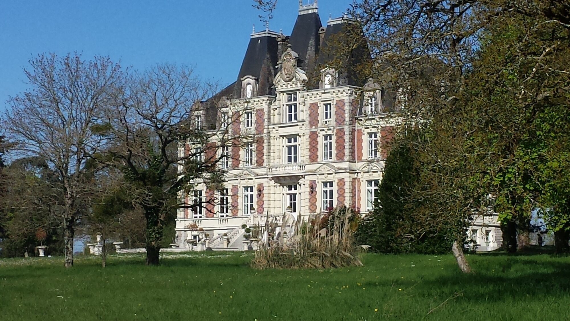
- The Renaissance-inspired Château de la Chaussée was built in 1872 by Count Tessié de la Motte, as evidenced by the intertwined T and M on the château's pediment. Its parkland of over 20 hectares is renowned for the richness and diversity of its exceptional tree species, listed by INRA.
Facilities available:
- Picnic tables in the Parc des Fontaines
Departure points :
- Church, rue de l'Aubriaie, Saint-Lambert-la-Potherie
- Salle de la Coudre, rue Ferrières, Saint-Léger-des-Bois (Saint-Léger-de-Linières)
Tour marked in mauve.


Route marked in purple.
Angers and its surroundings, rich in confluence landscapes, are sometimes subject to flood risks throughout the year. Some trails may be temporarily impassable; stay vigilant.
In case of emergency, dial 112.
Consider carpooling.
Parking near the starting point.
T1
Be vigilant, especially when crossing roads or when following them, as well as at all times in nature. It can sometimes present dangerous passages, flooded areas, steep sites, or slippery paths.
Follow the marked paths to avoid getting lost and to limit soil erosion and damage to natural habitats. Pay attention to the markings and in case of doubt, do not hesitate to turn back.
Do not pick protected species and keep a low profile so as not to disturb wildlife.
Some trails are used by cyclists, be vigilant.
This route and the associated GPX track may under no circumstances be shared without mentioning Destination Angers.
Popularne wycieczki w okolicy
-
4,0
The Anjou loop of La Loire à Vélo - with bac de la Chevalerie
światłoJazda na rowerze 39,1 km -
Lake, pond and tributary
światłoWędrówka 18,5 km -
To the confluence of the Loire and the Maine
światłoWędrówka 18,0 km -
Bucolic walk around Saint-Léger-de-Linières
światłoWędrówka 8,11 km -
Mayenne loop
światłoJazda na rowerze 25,5 km -
The Savennières vineyards
światłoWędrówka 9,59 km -
Walk around Saint-Martin-du-Fouilloux
światłoWędrówka 10,7 km -
A relaxing walk around Béhuard
światłoWędrówka 9,26 km -
The Mayenne river and meadows in the low valleys of Angers
światłoWędrówka 17,4 km -
Marcillé plateau to the towpath
światłoWędrówka 13,8 km
Wędrówki i tropienie


Nie przegap ofert i inspiracji na następne wakacje
Twój adres e-mail została dodana do listy mailingowej.