


Circular hike to the Judenlöcher at Hohenlupfen Castle
From the monastery location follow the yellow lozenge path to Hohenlupfen Castle and from there to the Ruckwald location. Then turn left on an unmarked forest path for about 1000 m back to the yellow lozenge...
From the monastery location follow the yellow lozenge path to Hohenlupfen Castle and from there to the Ruckwald location. Then turn left on an unmarked forest path for about 1000 m back to the yellow lozenge path over the Judenlöcher, then to Hohenlupfen Castle and then back to the monastery.
On the way to the castle there are beautiful viewpoints towards Schleitheim / Switzerland, and at the Judenlöcher you can also look into the Wutach Valley and Switzerland


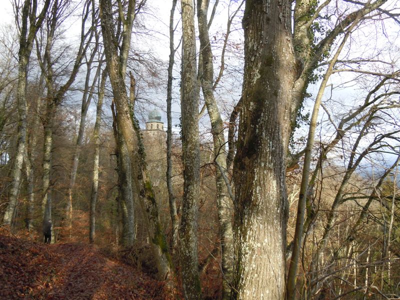


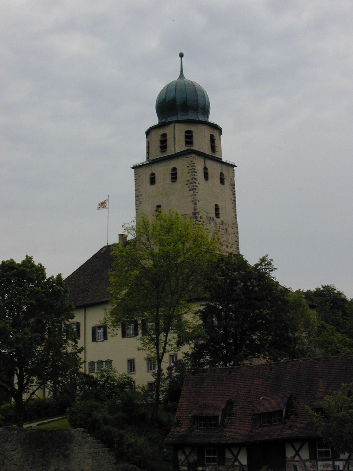

The yellow lozenge largely marks our way. We hike from the monastery location slightly uphill towards Hohenlupfen Castle, after about 300 meters we cross L 169 and continue on the opposite hiking path. Soon we reach Hohenlupfen Castle. We walk along the castle wall first to the left and shortly afterwards turn right at the Hohenlupfen Castle location. The narrow path now leads uphill to the plateau of the castle hill. Mighty beeches line our path. Be careful - it goes steeply downhill on the left. We pass the Prinz-Kari bench and enjoy the view into the Wutach Valley and towards Schleitheim. We continue on the path, briefly reaching the adjacent meadows twice, but after a few meters the yellow lozenge leads left back into the forest. At the Ruckwald location we leave the yellow lozenge for about 1000 meters. We turn left onto a wide forest path. At the first curve there is a high seat, we continue the marked forest management path to the left. At the beginning of the second left curve we see the yellow lozenge again on a hiking path, we have to keep sharp right. On narrow paths it then goes downhill along the yellow lozenge to the sign "Judenlöcher." According to legend, Stühlingen Jews sought shelter in them during the Thirty Years' War. They are passable up to a resting bench. After visiting the Judenlöcher the path leads further downhill, we reach a forest path again and follow it left. At the next fork after a barrier the yellow lozenge points left onto an ascending forest path which leads in several bends uphill towards the castle to the Hohenlupfen Castle location. Then it goes back to the monastery on the path walked at the beginning to the monastery location.
We recommend sturdy footwear!
From Freiburg:
B31 to Titisee, turn onto B317 towards Waldshut, then towards Lenzkirch/Bonndorf (B315), continue towards Stühlingen, in Wellendingen turn onto the panoramic road, past the golf course and continue to Stühlingen, after entering the town turn left towards hospital/monastery.
From Donaueschingen:
B27 to Blumberg, after the station of the Sauschwänzlebahn turn right towards Epfenhofen/Fützen. Then turn right again onto B314 towards Waldshut. At the entrance to Stühlingen keep right and drive uphill through the town to the old town and then follow the signs for hospital/monastery.
From Lörrach:
B317/B518 towards Waldshut-Tiengen, turn right onto B34/E54, exit towards A81/Stuttgart/Singen/Schaffhausen/Switzerland/Lauchringen, continue on B314 to Lauchringen
From Freiburg:
By train 727 to Neustadt, bus 7258 towards Bonndorf (in the Black Forest), get off at Rathaus Bonndorf. Bus 7346 towards Stühlingen, get off at Kirche
From Donaueschingen:
By bus 7277 towards Blumberg, get off at Zollhaus B27, bus 7338 towards Stühlingen. Get off at Kirche
From Lörrach:
By train to Basel Bad Bf, train to Lauchringen, by bus 7338 towards Stühlingen, get off at Kirche
Car park at the cemetery
Brochure of the Black Forest Association Stühlingen "Legendary Hikes" about the Ruckwibli.
Anniversary commemorative publication 125 years Black Forest Association Stühlingen section "The Pavilion on the Castle Hill" pages 20/21
Depending on the season, rare orchids grow along the path.
Popularne wycieczki w okolicy
-
4,7
Wutachschlucht Rundwanderung im Süd Schwarzwald
średniWędrówka 9,76 km -
5,0
Premium Hiking Trail - 3-Schluchten Tour
średniTrasa tematyczna 9,62 km -
4,6
Small Rheinfall Circular Route
światłoWędrówka 3,48 km -
5,0
Wutachschlucht+Lotenbachklamm
światłoWędrówka 10,0 km -
4,4
Wutach, Deutschland
średniWędrówka 14,6 km -
5,0
Berau - ruins, rocks & gorges
średniWędrówka 9,71 km -
5,0
Circular hike over the Hinterranden
średniWędrówka 11,0 km -
4,5
Nature trail Merishausen: Brown route
średniTrasa tematyczna 11,4 km -
4,5
SchweizMobil 593: Nordspitze Panoramaweg
średniWędrówka 13,7 km -
4,3
Kath. Kirche - Gasthaus Wutachschlucht - Buchberg - Gasthaus Schattenmühle
średnidługodystansowy szlak pieszy 39,1 km
Wędrówki i tropienie


Nie przegap ofert i inspiracji na następne wakacje
Twój adres e-mail została dodana do listy mailingowej.