Route around the Tourette
światło
Pobierz tę trasę na swój telefon komórkowy
Route around the Tourette
światło
Wędrówka
10,58
km
Zeskanuj kod QR i rozpocznij nawigację w aplikacji bergfex.

Wędrówki i tropienie


Route around the Tourette
światło
Odległość
10,58
km
Czas trwania
02:00
h
Ascent
244
hm
Poziom morza
224 -
419
m
Ścieżka do pobrania
Route around the Tourette
światło
Wędrówka
10,58
km
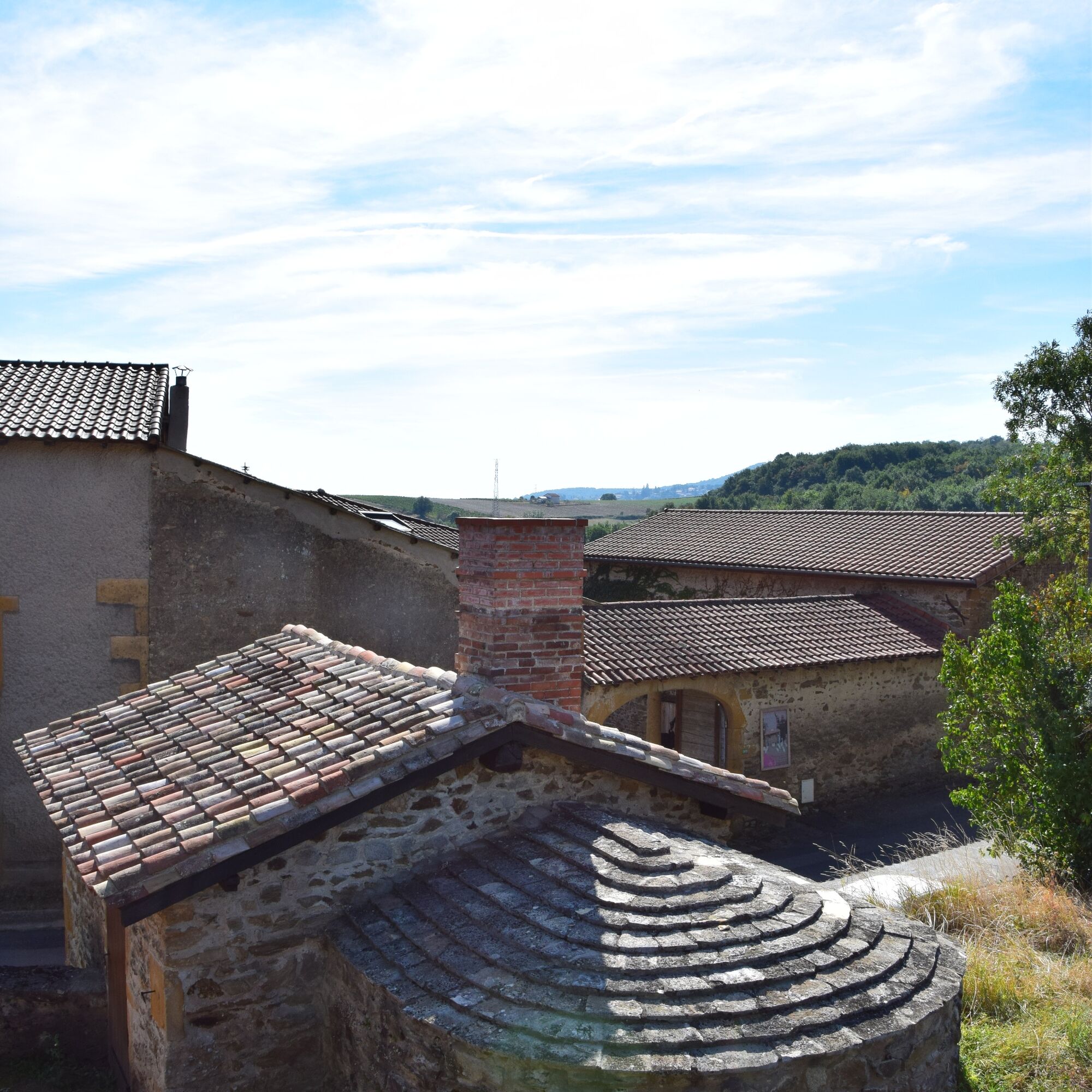
To discover on the route: The Morillon bread oven
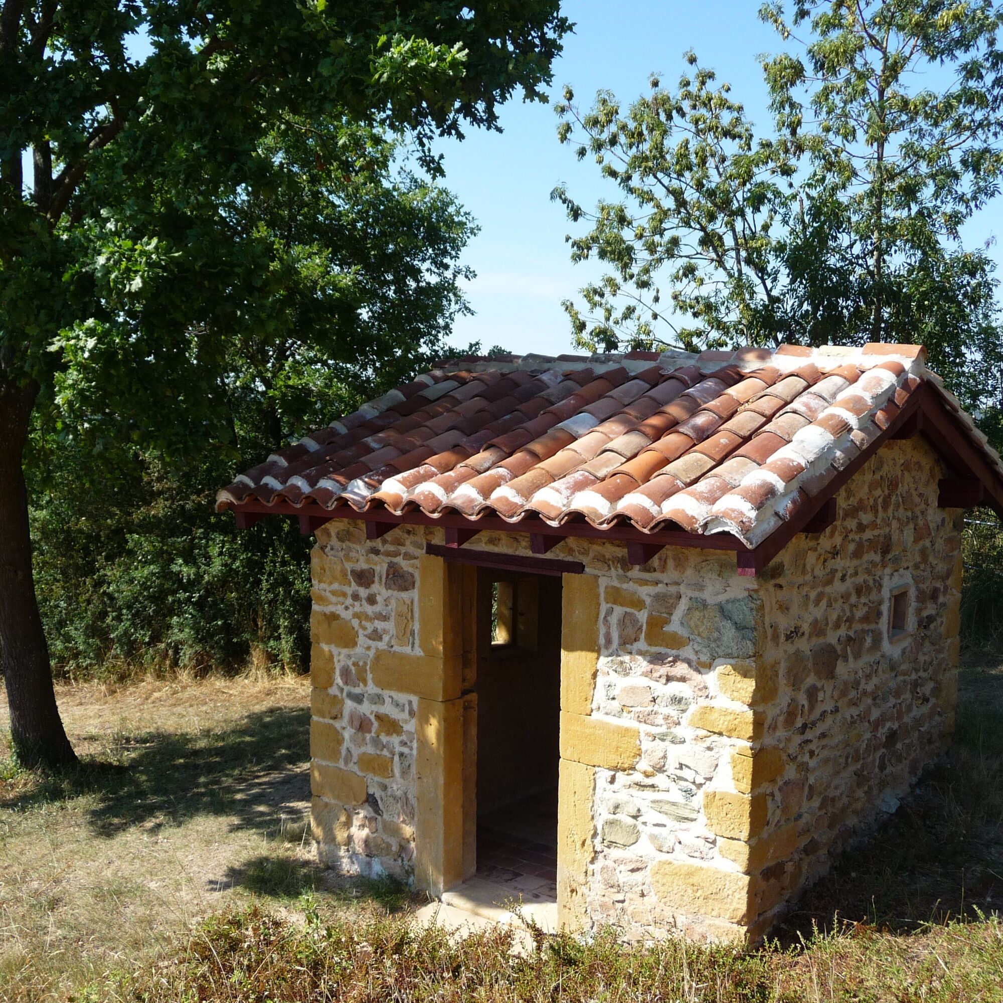
Built around the mid-18th century, it was the oven used by the hamlets of Lévy and Morillon. In 1999, volunteers from the association “Éveux et son patrimoine,”...
Opis
To discover on the route: The Morillon bread oven
Built around the mid-18th century, it was the oven used by the hamlets of Lévy and Morillon. In 1999, volunteers from the association “Éveux et son patrimoine,” assisted by the municipality, began an exemplary restoration of the building: reconstruction of the hearth and vault, new roof, enhancement of the surroundings… Since then, the oven functions on the occasion of some local events.
Built around the mid-18th century, it was the oven used by the hamlets of Lévy and Morillon. In 1999, volunteers from the association “Éveux et son patrimoine,” assisted by the municipality, began an exemplary restoration of the building: reconstruction of the hearth and vault, new roof, enhancement of the surroundings… Since then, the oven functions on the occasion of some local events.
Trasa
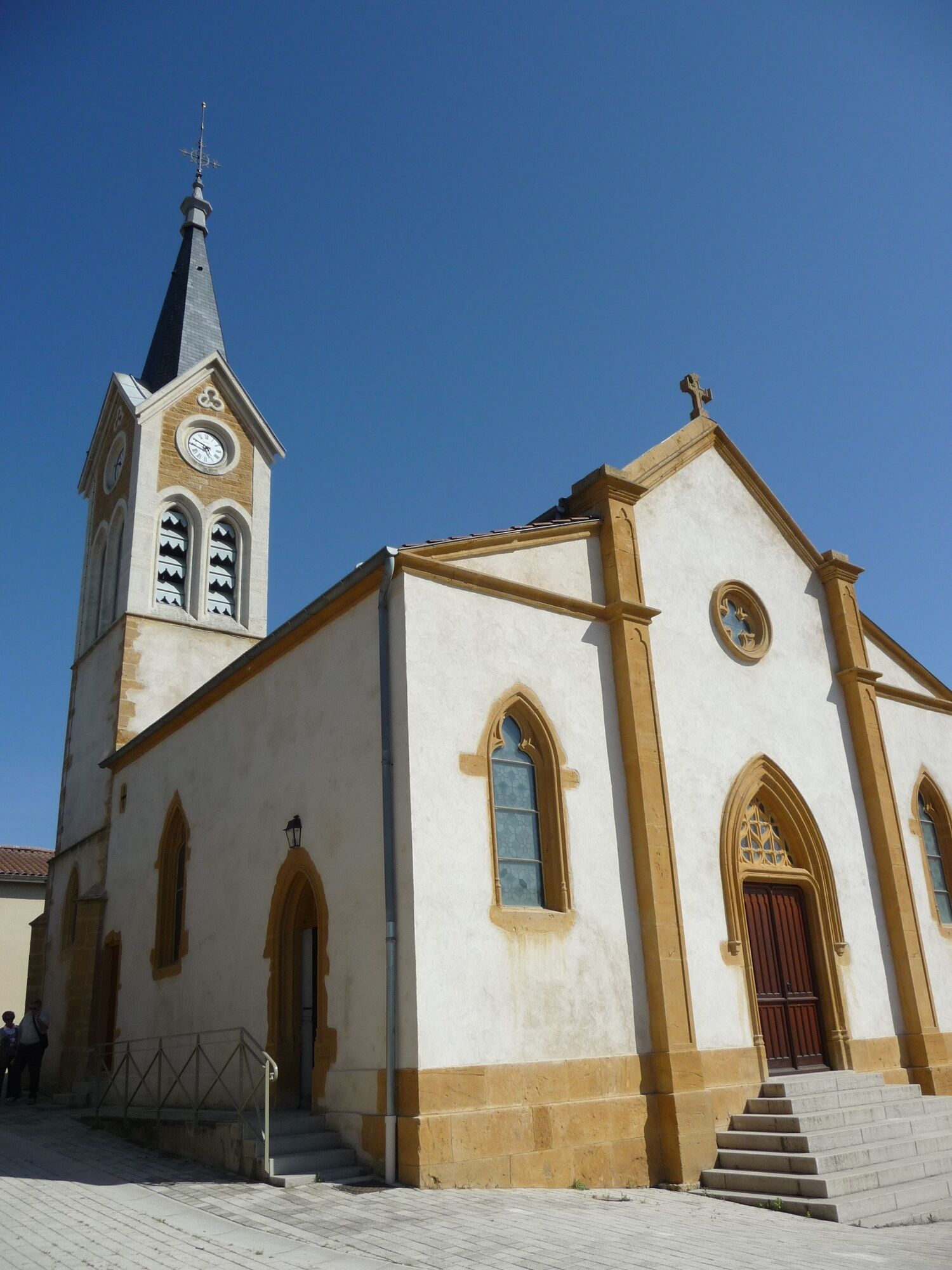
Église Saint-Pierre
(309 m)
Miejsce kultu
0,2 km
L'Arbresle
(229 m)
Wioska
1,5 km
Le Sonnay
(395 m)
Rozliczenie
5,3 km
Barbaron
(413 m)
Korytarz/teren
5,8 km
Les Tanneries
(310 m)
Rozliczenie
7,7 km
Lévy
(360 m)
Rozliczenie
8,7 km
Trasa
Route around the Tourette
światło
Wędrówka
10,58
km
Éveux
(310 m)
Wioska
0,0 km
Église Saint-Pierre
(309 m)
Miejsce kultu
0,2 km
L'instant
(309 m)
Restauracja
0,3 km
L'Arbresle
(229 m)
Wioska
1,5 km
Le Terminus
(228 m)
Restauracja
1,5 km
Le Bigout
(235 m)
Korytarz/teren
2,5 km
Les Grandes Terres
(378 m)
Korytarz/teren
5,0 km
Le Sonnay
(395 m)
Rozliczenie
5,3 km
Barbaron
(413 m)
Korytarz/teren
5,8 km
Les Hauts de Mosouvre
(421 m)
Korytarz/teren
6,4 km
Moiry
(375 m)
Korytarz/teren
6,9 km
Les Tanneries
(310 m)
Rozliczenie
7,7 km
Lévy
(360 m)
Rozliczenie
8,7 km
Éveux
(310 m)
Wioska
10,5 km
Autor
Dostarczone przez Monts du Lyonnais
Wycieczkę Route around the Tourette zapewnia outdooractive.com.

Udostępnij trasę
Route around the Tourette
światło
Wędrówka
10,58
km
Błąd
Wystąpił błąd. Spróbuj ponownie.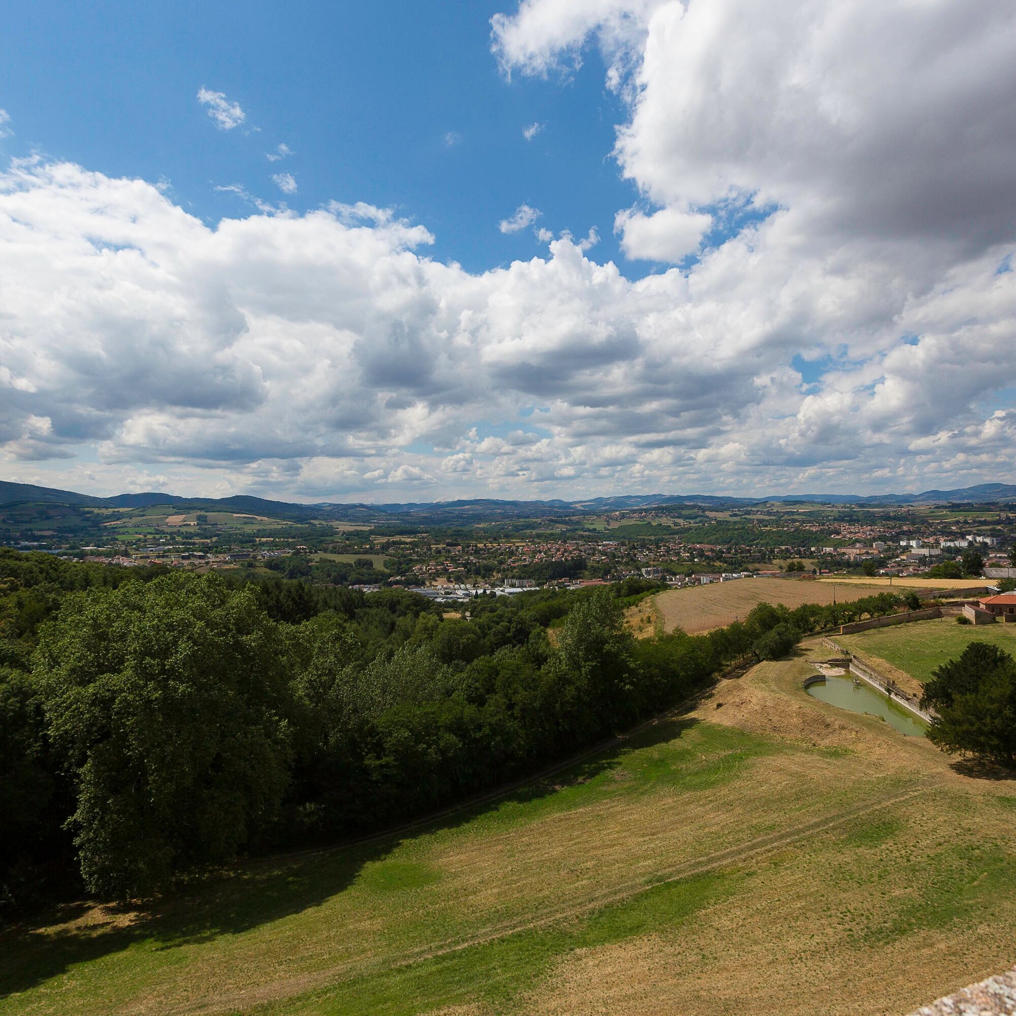
Informacje o trasie
Trasa
Start: in front of the Town Hall (parking nearby) Take rue de la Rencontre to the left while facing the Town Hall.
100 m later, take rue de la Fontaine to the right, go down to the place du Lavoir, where the cabin is located (near the well), go back up to the church and from the left side of the church head towards the Church Square.
At Church Square: there is a war memorial and an orientation table (church open during the day and may be visited). Take the passage in front of the daycare to reach the departmental road. Follow the sidewalk on the left descending to the first intersection, cross the road at the pedestrian crossing.
1: Take the Chemin des Rompières to the right until L’Arbresle station; leave rue des Tilleuls on your right, continue taking a right going down. A bit further, leave Chemin de la Plaine on your right and descend to the station. At the roundabout, cross the departmental road (pedestrian crossing) to go under the bridge and take a left to reach the station square.
2: Take the chemin de la Rivière in front of the Terminus hotel. Pass under the SNCF bridge, follow La Brévenne, and cross the Val des Chenevières park.
3 – At the Les Martinets wooden post, turn left behind the guardrail to the SNCF track at the fire station level. Cross the railway and the departmental road carefully to take the Grand Fonds path on the right. At the end of the straight line, turn left then climb about 160 m.
4- Leave the paved road to take the left path leading to the vineyard hut of la Côte (private hut restored by the association Éveux et son Patrimoine, open – shelter for hikers). Then continue climbing. At the intersection, turn right onto the paved path.
At the Les Balmes wooden post, take the direction of Sonnay, path along the wall of the Tourette domain. Further on, continue climbing left still along the wall of the Tourette domain. At the end of the wall, follow the chemin des Pierres Folles.
5- Turn left onto Chemin des Vignes. At the intersection with the paved road, go straight ahead. At the Le Sonnay wooden post, continue straight towards Barbaron via Route du Sonnay. At the Barbaron wooden post, continue straight toward Les Hauts de Mosouvre. At the Les Hauts de Mosouvre wooden post, continue straight toward Moiry.
6- At the intersection with the departmental road, cross it and take the small descending path. At the Moiry wooden post, turn left toward Gouttes de Bel Air following the road.
7- At the Les Tanneries wooden post, take the left direction to Morillon. You cross the Tanneries stream, then encounter removable wires blocking the path (put back after passing as there is a herd of cows in the fields). After passing the barn, you can visit the Lévy washhouse (restored by the Fleurieux Heritage association), then at the intersection with the road turn left.
A little further, cross the departmental road to take the chemin des Tébres. On your left is the Morillon bread oven restored by the association Éveux et son Patrimoine. There is a wooden shelter for hikers wishing to take cover.
8- At the Le Morillon wooden post, go straight towards L’Hèbre. At the L’Hèbre wooden post, turn left towards Les Roches, then straight towards Les Noisetiers. At Les Noisetiers post, cross the roundabout straight ahead to return to Éveux town hall.
Dodatkowe informacje i wskazówki
Dodatkowe informacje
Accessibility by public transport: Departure for the walk is possible from the SNCF station of L'Arbresle (TER lines No. 6 and No. 22).
You then start your walk at point No. 2 by following the route.
Nie ma jeszcze recenzji
Popularne wycieczki w okolicy
The forest of Flachère - Beaujolais - Légny
światłoWędrówka 6,68 kmPorte des Pierres Dorées - Beaujolais - Jarnioux
światłoWędrówka 14,8 kmRegina, Duroni, Sweetheart - Monts du Lyonnais - Bessenay
światłoWędrówka 13,6 kmLet's walk in the woods - Monts du Lyonnais - Pollionnay
światłoWędrówka 12,6 kmThe Panoramique
światłoWędrówka 7,56 kmMała wycieczka po crêt d'Arjoux - Monts du Lyonnais - Saint-Julien-sur-Bibost
światłoWędrówka 4,93 kmCourz'y Trail Park - Circuit No. 1: La Découverte
światłoTrailrunning 7,27 kmZ Velair do Saint-Bonnet-le-Froid - Monts du Lyonnais - Courzieu
ciężkiWędrówka 14,7 km- 5,0
MTB Circuit 23 - The Poirier
światłoMountainbike 15,6 km Courz'y Trail Park - Circuit No. 5: La Montée Infernale
ciężkiTrailrunning 2,85 km
Wędrówki i tropienie

Ponad 550.000 propozycji wycieczek, szczegółowe mapy i intuicyjny planer tras sprawiają, że aplikacja jest niezbędna dla wszystkich entuzjastów przyrody.

Nie przegap ofert i inspiracji na następne wakacje
Zapisz się do newslettera
Błąd
Wystąpił błąd. Spróbuj ponownie.Dziękujemy za rejestrację
Twój adres e-mail została dodana do listy mailingowej.
Wycieczki po całej Europie
Austria Szwajcaria Niemcy Włochy Słowenię Francja Holandia Belgia Polska Liechtenstein Czechy Słowacja Hiszpania Chorwacja Bośnia i Hercegowina Luksemburg Andorra Portugalia Islandia Wielka Brytania Irlandia Grecja Albania Macedonia Północna Malta Norwegia Czarnogóra Mołdawia Kosowo Węgry San Marino Rumunia Estonia Łotwa Białoruś Cypr Litwa Serbia Bułgaria Monako Dania Szwecja Finlandia