Le Beaujolais Vert - Around the summits of Beaujolais - Loop 3.1
ciężki
Nawigacja
Nawigacja
Pobierz tę trasę na swój telefon komórkowy
Le Beaujolais Vert - Around the summits of Beaujolais - Loop 3.1
ciężki
Droga rowerowa
37,73
km
Zeskanuj kod QR i rozpocznij nawigację w aplikacji bergfex.

Wędrówki i tropienie


Le Beaujolais Vert - Around the summits of Beaujolais - Loop 3.1
ciężki
Odległość
37,73
km
Czas trwania
03:00
h
Ascent
696
hm
Poziom morza
450 -
854
m
Ścieżka do pobrania
Le Beaujolais Vert - Around the summits of Beaujolais - Loop 3.1
ciężki
Droga rowerowa
37,73
km
Sporty side
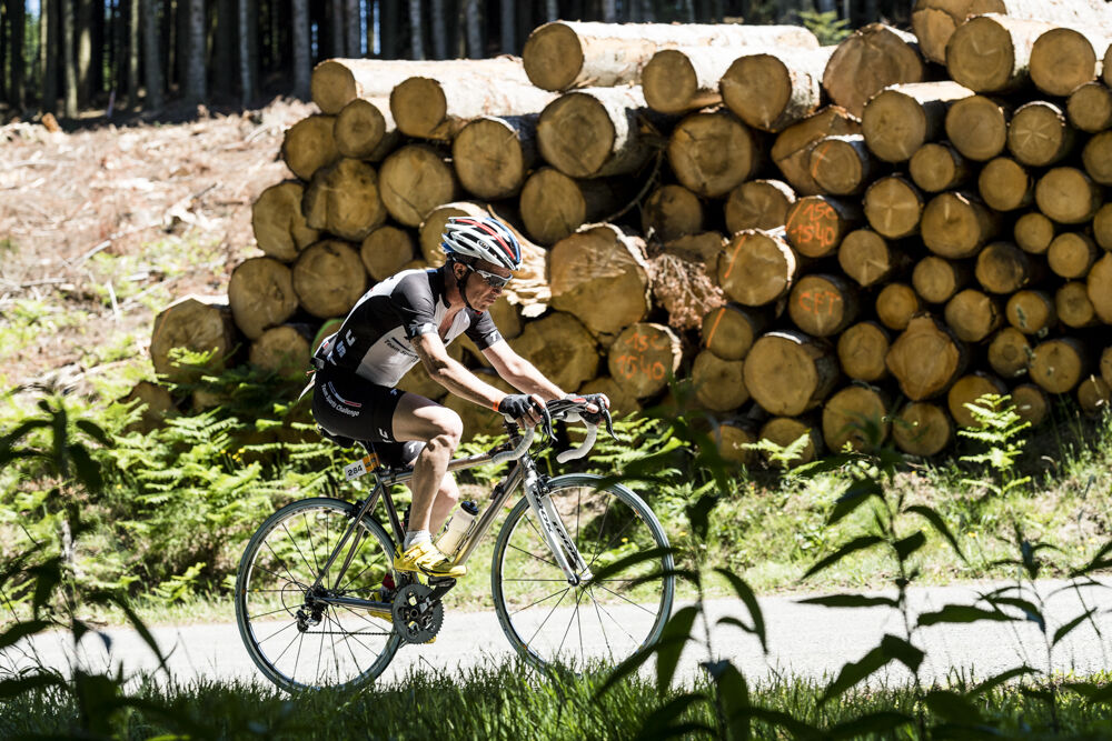
Less than 40 km, but difficult, this route will delight experienced cyclists, lovers of steep climbs. Small gear ratios will be appreciated.
From the start of Claveisolles the road rises up to...
Opis
Sporty side
Less than 40 km, but difficult, this route will delight experienced cyclists, lovers of steep climbs. Small gear ratios will be appreciated.
From the start of Claveisolles the road rises up to Poule-les-Echarmeaux (final slope of 10%). All that remains is to climb the Cols des Aillets, then the Echarmeaux and above all the Croix d’Ajoux (final around 15%…). Reaching the Col de la Casse Froide is easy and the beautiful descent (6%) of 5 km is appreciated reaching the finish.
Tourism side
Haut-Beaujolais surprises with the contrasting beauty of its landscapes: steep-sided valleys, bocage plateaus, valleys furrowed by the meanders of rivers… It is one of the main peaks of the Rhône: Saint-Rigaud, the highest in the department at 1,012 m, visible from the intersection of the RD 139 and 645, the Tourvéon (949 m), wooded pyramid which captures the eye when climbing to Les Aillets or the rock of Ajoux (970 m), pedestal mineral, which offers a remarkable panorama of the Alps and the Massif Central.
Trasa
Église de Lafont
(545 m)
Miejsce kultu
3,6 km
La Nuizière d'En-Bas
(608 m)
Rozliczenie
6,5 km
Église Saint-Martin
(577 m)
Miejsce kultu
10,1 km
La Buffaudière
(597 m)
Rozliczenie
11,9 km
La Molière
(641 m)
Rozliczenie
18,7 km
Église Sainte-Madeleine
(668 m)
Miejsce kultu
25,8 km
Valtorte
(656 m)
Rozliczenie
34,0 km
Trasa
Le Beaujolais Vert - Around the summits of Beaujolais - Loop 3.1
ciężki
Droga rowerowa
37,73
km
Claveisolles
(460 m)
Wioska
0,0 km
Église de Lafont
(545 m)
Miejsce kultu
3,6 km
Lafont
(543 m)
Rozliczenie
3,7 km
La Nuizière d'En-Haut
(616 m)
Rozliczenie
5,6 km
La Nuizière d'En-Bas
(608 m)
Rozliczenie
6,5 km
Les Trêves
(660 m)
Rozliczenie
7,5 km
Les Fougères
(584 m)
Rozliczenie
8,8 km
La Combe
(581 m)
Rozliczenie
9,4 km
Poule-les-Écharmeaux
(579 m)
Wioska
9,9 km
Au Ricochet
(578 m)
Restauracja
10,0 km
Église Saint-Martin
(577 m)
Miejsce kultu
10,1 km
La Fabrique
(536 m)
Rozliczenie
10,5 km
La Buffaudière
(597 m)
Rozliczenie
11,9 km
Le Suchet
(649 m)
Rozliczenie
13,2 km
Le Perron
(696 m)
Rozliczenie
14,9 km
Les Écharmeaux
(708 m)
Rozliczenie
16,8 km
La Molière
(641 m)
Rozliczenie
18,7 km
Les Colombières
(654 m)
Sąsiedztwo
19,4 km
Propières
(657 m)
Wioska
19,6 km
Le Paquier
(654 m)
Rozliczenie
19,9 km
La Voisinée
(712 m)
Rozliczenie
24,3 km
Chénelette
(661 m)
Wioska
25,1 km
Église Sainte-Madeleine
(668 m)
Miejsce kultu
25,8 km
Les Grand'Cours
(665 m)
Rozliczenie
29,0 km
Casse Froide
(744 m)
Korytarz/teren
33,1 km
Valtorte
(656 m)
Rozliczenie
34,0 km
Plat des Granges
(522 m)
Rozliczenie
36,7 km
Claveisolles
(460 m)
Wioska
37,6 km
Autor
Dostarczone przez Rhône Tourisme
Wycieczkę Le Beaujolais Vert - Around the summits of Beaujolais - Loop 3.1 zapewnia outdooractive.com.
Nie ma jeszcze recenzji
Popularne wycieczki w okolicy
-
De l’Aze à l’Ergues - Beaujolais Vert - Claveisolles
światłoWędrówka 13,0 km -
5,0
B3 Mountain Bike Tour from Beaujeu to St Didier/Beaujeu
ciężkiMountainbike 22,6 km -
Mont Brouilly, between vines and culture - Beaujolais - Saint-Lager
światłoWędrówka 7,47 km -
The Beaujolais vineyard - Beaujolais - Chiroubles
światłoWędrówka 12,5 km -
B9 Mountain Bike Tour Marchampt
ciężkiMountainbike 19,8 km -
M12 Mountain Bike Tour B2 from Monsols to Ouroux
ciężkiMountainbike 22,5 km -
M2 Mountain Bike Tour from St Bonnet to St Christophe
ciężkiMountainbike 35,6 km -
Circuit VTT M9 de propières à Azolette
ciężkiMountainbike 20,4 km -
M5 Mountain Bike Tour from Trades to St. Christopher
ciężkiMountainbike 16,5 km -
The tour of the Crochet mountain and Tourvéon mount
światłoWędrówka 13,1 km

Wędrówki i tropienie

Ponad 550.000 propozycji wycieczek, szczegółowe mapy i intuicyjny planer tras sprawiają, że aplikacja jest niezbędna dla wszystkich entuzjastów przyrody.

Nie przegap ofert i inspiracji na następne wakacje
Zapisz się do newslettera
Błąd
Wystąpił błąd. Spróbuj ponownie.
Dziękujemy za rejestrację
Twój adres e-mail została dodana do listy mailingowej.
Wycieczki po całej Europie
Austria
Szwajcaria
Niemcy
Włochy
Słowenię
Francja
Holandia
Belgia
Polska
Liechtenstein
Czechy
Słowacja
Hiszpania
Chorwacja
Bośnia i Hercegowina
Luksemburg
Andorra
Portugalia
Islandia
Wielka Brytania
Irlandia
Grecja
Albania
Macedonia Północna
Malta
Norwegia
Czarnogóra
Mołdawia
Kosowo
Węgry
San Marino
Rumunia
Estonia
Łotwa
Białoruś
Cypr
Litwa
Serbia
Bułgaria
Monako
Dania
Szwecja
Finlandia