


Georoute Leisnig "Porphyry - Mulde - old walls"
This circular hike leads mostly on signposted paths along both sides of the Freiberger Mulde. Along the route, impressive geotopes such as the large red porphyry wall below Mildenstein Castle or similar...
This circular hike leads mostly on signposted paths along both sides of the Freiberger Mulde. Along the route, impressive geotopes such as the large red porphyry wall below Mildenstein Castle or similar rock walls on the Riedelsteig can be admired. The local porphyry is not only an important building material of the region but also gives the Geopark its name.
In an idyllic river loop of the primeval course of the Freiberger lies the former Cistercian monastery Buch. The monastery was founded in 1192 by the burgrave of Leisnig.
On the opposite side, the two viewpoints Wettinstein and Maylust offer an impressive view into the Mulde valley. From here, Mildenstein Castle can already be seen and admired. The two viewpoints are connected by a romantic forest path along the porphyry cliffs.
The return route across the Leisnig Mulde bridge allows a final view of the impressive rock plateau with the town of Leisnig and Mildenstein Castle, whose subsequent visit is highly recommended.

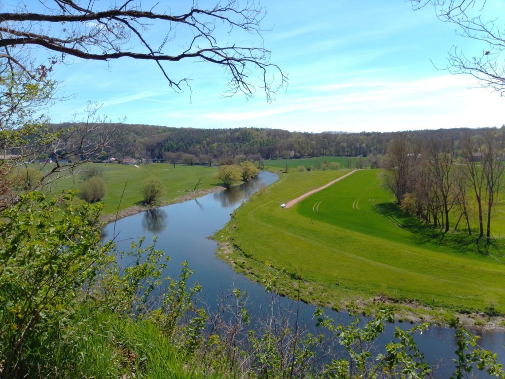
Starting at the Fischendorf hiking car park, a detour first leads over the footbridge to the large red porphyry wall below Mildenstein Castle. Those arriving by train take the route over the Mulde bridge or the part of Bergstraße running through the valley to the red wall and continue over the footbridge to the hiking car park. From there, the local hiking trail R3 leads over Waldstraße and behind an old factory site to the Riedelsteig on the northern bank of the Freiberger Mulde to Klosterbuch. Here, a visit to the former Cistercian monastery Buch is recommended. After crossing the Mulde bridge, we leave the signposted route and reach the viewpoints Wettinstein and Maylust via the Klostersteig. From there, we follow the Muldental hiking trail Freiberger Mulde (Tannenbergweg) to the fork in the road at Wendishain, keep right and follow the road (K 7540) uphill. Alternatively, immediately opposite the fork, we turn onto the unmarked forest path. At the Paudritzsch nursing home, the path meets the local hiking trail R3 (Muldental hiking trail, K 7540) again. From there, we continue our route to Eichberg. On the Eichgrundweg, developed as a 'nature trail', it leads back to Leisnig. After a few hundred meters on G.-F.-Händel-Straße or on the parallel Bahnhofstraße running below (signposted cycle route) towards the center, we reach Leisnig station. The route back to the hiking car park leads over the Mulde bridge, past the rock plateau with the town and the castle Leisnig. For a detour there, we choose Schlossstraße uphill shortly before the bridge. Alternatively, we reach the red porphyry wall and the footbridge at the starting point via Bergstraße (in the valley next to the railway tracks).
Tak
Arrival by car: via A 14, exit Leisnig - S 31 - S 36
Arrival by train: Leipzig-Döbeln route, Leisnig stop
Hiking car park Fischendorf, on the S 36
Popularne wycieczki w okolicy
-
Saksoński Szlak Lutra - trasa dojazdowa z Wermsdorf do Glossen
światłoTrasa pielgrzymki 8,74 km -
5,0
Talsperrenrundweg Kriebstein mit Fährüberfahrt
średniWędrówka 6,12 km -
Geo Route Leisnig: Porphyry and Old Town Stories
światłoTrasa tematyczna 1,65 km -
Mulderadweg Rochlitz-Sermuth
światłoJazda na rowerze 16,6 km -
Saksoński Szlak Lutra z Döbeln do Waldheim
średniTrasa pielgrzymki 18,2 km -
Muldental-Wanderweg Etappe Rochlitz-Colditz
średniWędrówka 14,8 km -
Rundweg von Leisnig zum Kloster Buch
światłoWędrówka 13,7 km -
Ehrenberg nach Tannenberg u. zurück
średniWędrówka 14,7 km -
Colditzer Rundwanderung
średniWędrówka 17,3 km -
Sornziger Runde
Trasa tematyczna 14,7 km

Wędrówki i tropienie


Nie przegap ofert i inspiracji na następne wakacje
Twój adres e-mail została dodana do listy mailingowej.