


Palatia-Route

The Palatia cycle route connects the Palatinate Forest and the Rhine in a natural way. The tour starts at the Domplatz in Speyer. Further west through the Dudenhofen city forest, along the Waldgraben and...
The Palatia cycle route connects the Palatinate Forest and the Rhine in a natural way. The tour starts at the Domplatz in Speyer. Further west through the Dudenhofen city forest, along the Waldgraben and the Speyerbach, you pass Holiday Park and reach Neustadt an der Weinstraße via Speyerdorf. This stretch travels on forest and agricultural roads.
CAUTION: This route may be marked with different trail signs!

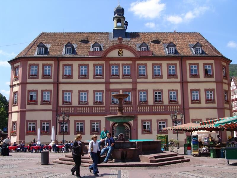
Behind you the gigantic cathedral and in front of you the paved Maximilianstraße your route begins. Over the traffic-calmed Maximilianstraße towards the Altpörtel city gate tower and then underneath it. Immediately afterwards at Postplatz turn right into Mühlturmstraße. After the railway crossing, again turn right into Holzstraße and follow along the Speyerbach out of the city. The path first leads past the cycling community of Dudenhofen. Rudi Altig once trained on the cycling track on Iggelheimer Straße. The route continues through the Gäu, a flat landscape interspersed with streams, in the direction of the Wine Route. North of Lachen-Speyerdorf, the cycle path shares a short section with the Kraut-und-Rüben cycle path before the latter turns south. Along the Speyerbach and Rehbach, it goes to Neustadt. First via Harthäuserweg, then left into Robert-Stolz-Straße and again left along Martin-Luther-Straße. At the second street, turn right into Konrad-Adenauer-Straße, which leads into the city centre. Continue through Kellereistraße to the market square. There, cozy cafés and restaurants invite you to stop. Also worth seeing are the town hall and collegiate church. Continue on Rathausstraße. At the end turn left into Sauterstraße. Continue on Wolfsburgstraße and turn left into Würzmühle. Follow the B39 (Talstraße) out of town. Shortly before Lambrecht, turn left into Wiesenstraße. After one kilometer, turn right into Fabrikstraße and the cycle path meets the B39 (Hauptstraße) again. We follow this only a short distance and then turn right into Bahnhofstraße. After a short climb, the destination is reached.
Touring bike or bicycle with multiple gears, weatherproof clothing, drinks, and provisions.
Please wear a helmet. Road traffic regulations must be observed.
A 61, exit towards Speyer, to exit SP-Zentrum, continue on B 9 towards cathedral / museums
Follow the parking guidance system to "Festplatz", walking distance to the cathedral: 5 minutes.
From Mannheim Hauptbahnhof with the S-Bahn S3 / S4 towards Germersheim, to SP main station. (Change to City-Shuttle, line 565 to Domplatz)
P + R parking lot "Festplatz" (GPS: Klipfelsau) or alternatively "Naturfreundehaus" (GPS: Schillerweg) or Technik Museum (GPS: Am Technik Museum 1)
Tourist Information Speyer
Maximilianstraße 13
67346 Speyer
Tel.: 0 62 32-14 23 92
Fax: 0 62 32 -14 23 32
Email: touristinformation@stadt-speyer.de
www.speyer.de
Don't miss: Speyer Cathedral (UNESCO World Heritage Site), more info: www.dom-zu-speyer.de .
Here you find hosts specialized for your needs: Bett + Bike - providers .
For your culinary enjoyment: Speyer restaurateurs .
Want to know what's happening in Speyer? Here is Speyer.de
Would you like to be the first to know what awaits our guests in the coming weeks in the cathedral and imperial city of Speyer? Then quickly subscribe to the Speyer newsletter: http://www.speyer.de/sv_speyer/de/Tourismus/Service/Newsletter/
CAUTION: The route may be marked with different trail signs!
Kamery internetowe z trasy
Popularne wycieczki w okolicy
-
4,5
From Deidesheim over the Heidenlöcher to Eckkopf
średniWędrówka 14,6 km -
Wachenheim - Eckkopf - Heidenlöcher - Wachenheim
średniWędrówka 12,8 km -
5,0
Wachenheimer Valleys Route to Oppauer Haus
średniWędrówka 11,7 km -
4,0
Thomas‘ Waldweinstube über die Wachtenburg
światłoWędrówka 4,81 km -
5,0
Vom Hambacher Schloss auf die Kalmit
średniWędrówka 11,3 km -
5,0
Rundtour Roth unter Riethburg
średniWędrówka 14,5 km -
Neustadt, Kaltenbrunner Tal, Totenkopfhütte, Hellerhütte, Königsberg, Neustadt Neustadt an der Weinstraße, Rheinland-Pfalz
światłoWędrówka 18,1 km -
Palatinate Wine Steig Stage 03 Bad Dürkheim - Deidesheim
średnidługodystansowy szlak pieszy 15,2 km -
Palatinate Wine Route stage 05 Neustadt a. d. Weinstraße - St. Martin
ciężkidługodystansowy szlak pieszy 19,8 km -
3,0
Maikammer - Palatinate Almond Trail (Circular Route)
światłoTrasa tematyczna 14,6 km
Wędrówki i tropienie


Nie przegap ofert i inspiracji na następne wakacje
Twój adres e-mail została dodana do listy mailingowej.