V863 - Around the Luberon by bike
średni
Pobierz tę trasę na swój telefon komórkowy
V863 - Around the Luberon by bike
średni
Droga rowerowa
240,17
km
Zeskanuj kod QR i rozpocznij nawigację w aplikacji bergfex.

Wędrówki i tropienie


V863 - Around the Luberon by bike
średni
Odległość
240,17
km
Czas trwania
23:45
h
Ascent
2 755
hm
Poziom morza
71 -
781
m
Poziom trudności: 2
Ścieżka do pobrania
V863 - Around the Luberon by bike
średni
Droga rowerowa
240,17
km
The route takes you through numerous perched villages, dry stone huts (bories), castles, monuments, but also humble buildings: washhouses, fountains, chapels...
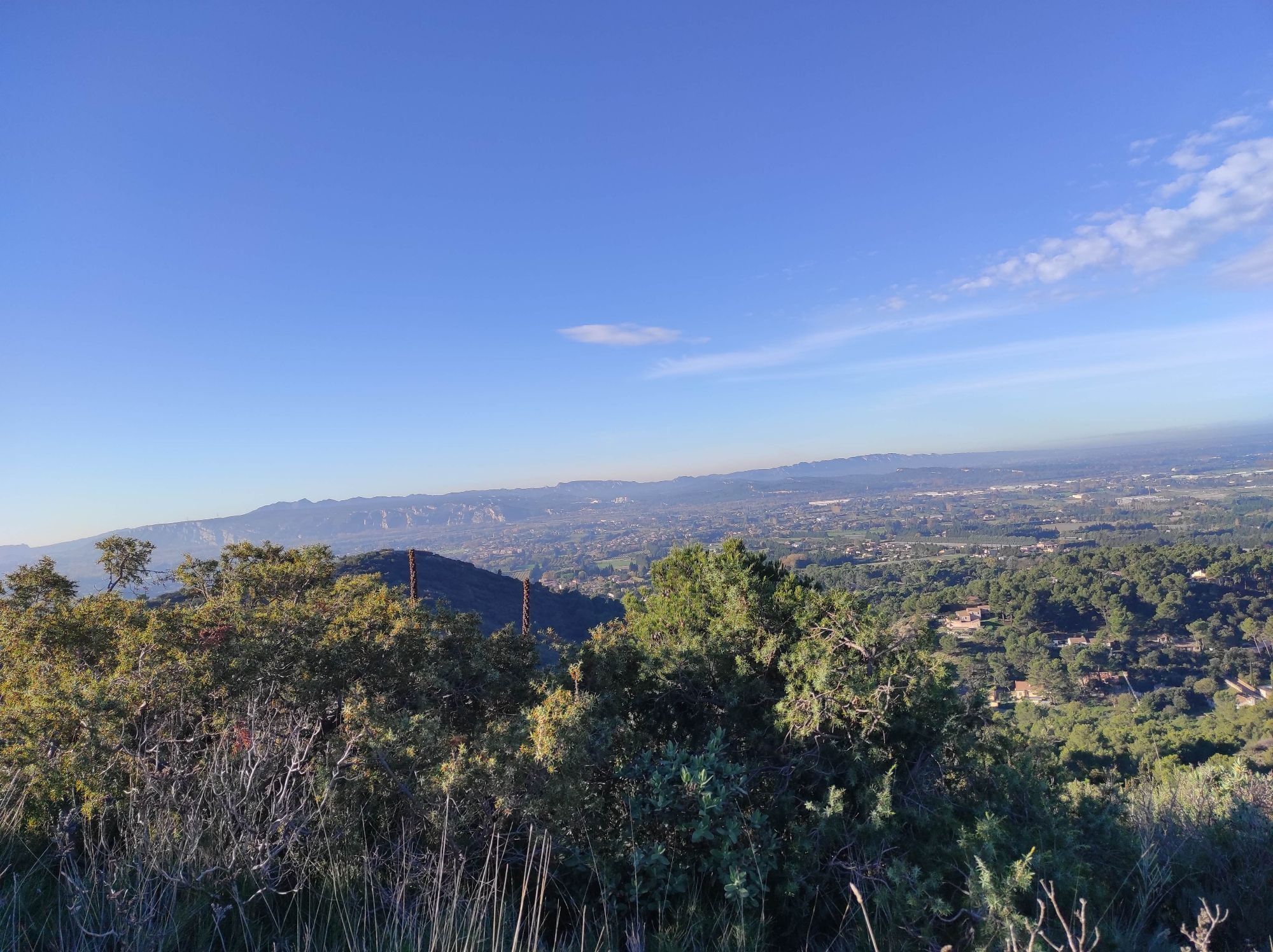
Cliffs and scrubland, crest grasslands, gorges,...
Opis
The route takes you through numerous perched villages, dry stone huts (bories), castles, monuments, but also humble buildings: washhouses, fountains, chapels...
Cliffs and scrubland, crest grasslands, gorges, cedar forest, ochre cliffs... so many different environments and atmospheres grouped within an area of 60 km by 30. The route uses small roads chosen for the beauty of the sites and villages welcoming you at your stops. Although they are generally lightly trafficked, you will have to share them with other users. The terrain characterizing our landscapes is sometimes marked by slopes that are not always gentle. Know that they are generally short and take the opportunity to enjoy walking part of the way.
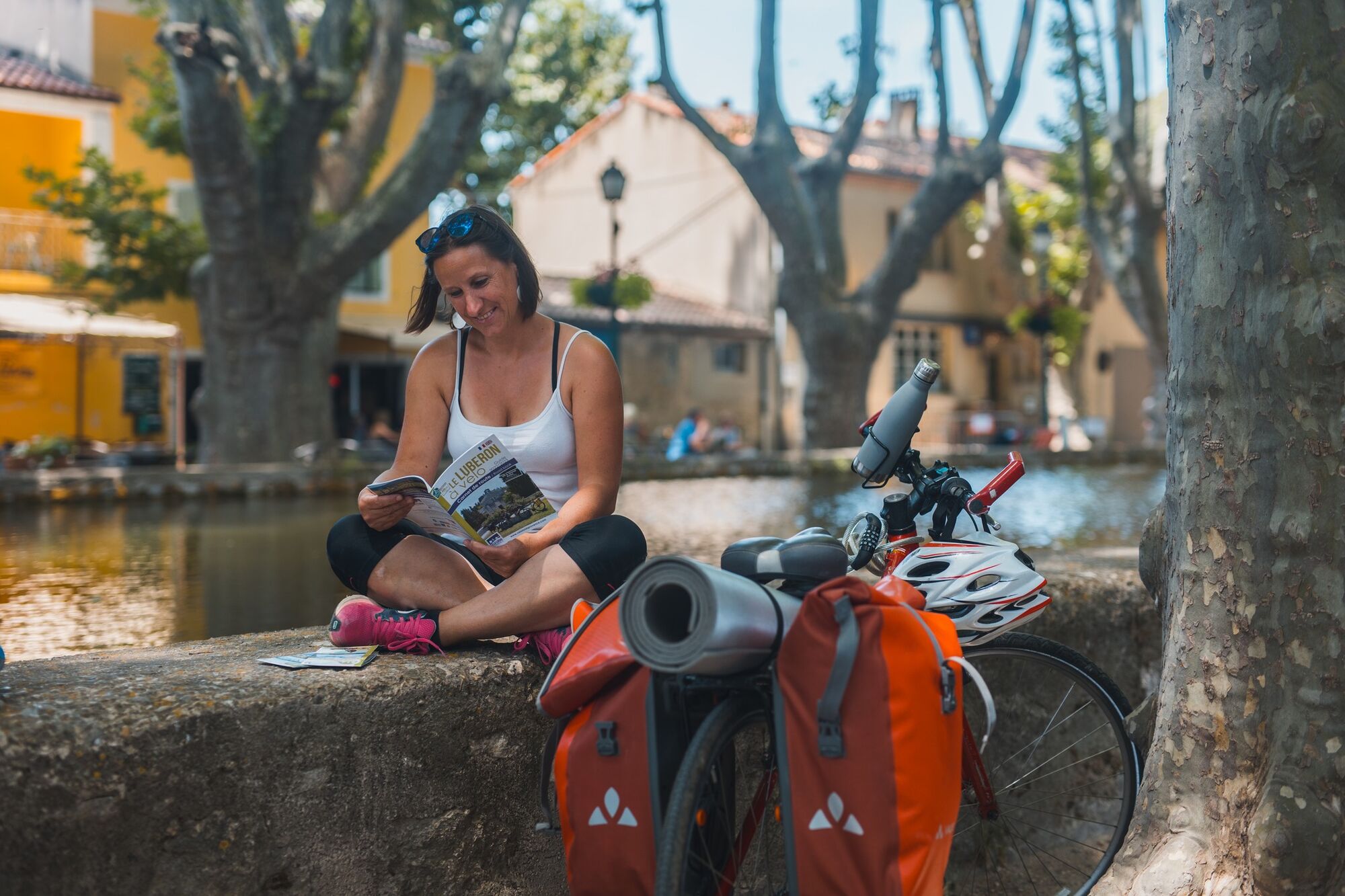
A Luberon route full of flavors!
Witnesses of a way of life also expressed through artisanal products, wines (A.O.C Côtes du Luberon and Côtes du Ventoux, Coteaux de Pierrevert) as well as gastronomy (candied fruits from Apt, goat cheese, honey, olive oil, fruits and vegetables...); farmers' markets or weekly markets are meeting points and highlights of this local life.
Cliffs and scrubland, crest grasslands, gorges, cedar forest, ochre cliffs... so many different environments and atmospheres grouped within an area of 60 km by 30. The route uses small roads chosen for the beauty of the sites and villages welcoming you at your stops. Although they are generally lightly trafficked, you will have to share them with other users. The terrain characterizing our landscapes is sometimes marked by slopes that are not always gentle. Know that they are generally short and take the opportunity to enjoy walking part of the way.
A Luberon route full of flavors!
Witnesses of a way of life also expressed through artisanal products, wines (A.O.C Côtes du Luberon and Côtes du Ventoux, Coteaux de Pierrevert) as well as gastronomy (candied fruits from Apt, goat cheese, honey, olive oil, fruits and vegetables...); farmers' markets or weekly markets are meeting points and highlights of this local life.
Trasa
Manosque
(384 m)
Miasto
0,1 km
La Bombardière
(604 m)
Szczyt
28,4 km
Église Saint-Michel
(389 m)
Miejsce kultu
70,4 km
Église Saint-Maurice
(137 m)
Miejsce kultu
127,4 km
Église Sainte-Anne
(162 m)
Miejsce kultu
161,1 km
Église Saint-Florent-et-Saint-Florentin
(375 m)
Miejsce kultu
196,2 km
Chapelle Saint-Marc La Bast
(433 m)
Miejsce kultu
212,5 km
Trasa
V863 - Around the Luberon by bike
średni
Droga rowerowa
240,17
km
Manosque
(384 m)
Miasto
0,1 km
Faubourg Saint-Lazare
(360 m)
Sąsiedztwo
0,4 km
Le Moulin Neuf
(313 m)
Sąsiedztwo
2,9 km
La Pigne
(312 m)
Rozliczenie
5,2 km
Les Quintrands
(343 m)
Sąsiedztwo
7,0 km
Playgroung
(376 m)
Plac zabaw
10,1 km
Volx
(375 m)
Wioska
11,1 km
Estaminet 36
(376 m)
Restauracja
11,1 km
Le Petit Ribier
(351 m)
Restauracja
12,7 km
Les Quatre Tours
(363 m)
Sąsiedztwo
14,5 km
Le Devens
(376 m)
Sąsiedztwo
15,3 km
Lorenzo Pizza
(433 m)
Restauracja
16,4 km
Villeneuve
(442 m)
Wioska
16,5 km
Burlière
(420 m)
Sąsiedztwo
17,0 km
Pierretier
(449 m)
Sąsiedztwo
17,6 km
La Bombardière
(604 m)
Szczyt
28,4 km
Forcalquier
(555 m)
Wioska
29,1 km
Saint-Maime
(429 m)
Wioska
36,0 km
Saint-Michel-l'Observatoire
(561 m)
Wioska
44,8 km
La Table du "Galilée"
(564 m)
Restauracja
44,9 km
Auberge des coupoles
(563 m)
Restauracja
44,9 km
Trou de Cote Chaude
(638 m)
Wejście do jaskini
52,7 km
Reillanne
(548 m)
Wioska
61,2 km
Église Notre-Dame de l'Assomption
(543 m)
Miejsce kultu
61,3 km
Café de la Place
(536 m)
Restauracja
61,4 km
Prieuré de Carluc
(446 m)
Miejsce kultu
66,3 km
Chapelle Notre-Dame-de-Piété
(373 m)
Miejsce kultu
70,2 km
Église Saint-Michel
(389 m)
Miejsce kultu
70,4 km
Hôtel Restaurant L'Aiguebelle
(386 m)
Restauracja
70,4 km
Céreste-en-Luberon
(390 m)
Wioska
70,6 km
Auberge de Carluc
(386 m)
Restauracja
70,6 km
La Tour de Pizz
(389 m)
Restauracja
70,6 km
Saint-Bernard
(406 m)
Sąsiedztwo
70,7 km
Le Laquet
(424 m)
Sąsiedztwo
71,1 km
Église Saint-Jean-Baptiste
(330 m)
Miejsce kultu
79,3 km
Le Boisset
(332 m)
Rozliczenie
79,3 km
Les Gaudins
(339 m)
Rozliczenie
81,3 km
Apt
(225 m)
Miasto
92,3 km
Les Tourettes
(388 m)
Rozliczenie
98,8 km
Les Chapelins
(392 m)
Rozliczenie
101,5 km
Église de la Transfiguration
(340 m)
Miejsce kultu
105,4 km
Bonnieux
(365 m)
Wioska
105,5 km
Lacoste
(320 m)
Wioska
111,1 km
Café de France
(300 m)
Restauracja
111,2 km
Ménerbes
(234 m)
Wioska
119,8 km
Le Petit Cafe
(240 m)
Restauracja
124,4 km
Oppède-le-Vieux
(240 m)
Rozliczenie
124,5 km
Maubec
(153 m)
Wioska
127,4 km
Église Saint-Maurice
(137 m)
Miejsce kultu
127,4 km
La Bergerie
(138 m)
Restauracja
127,6 km
Robion
(137 m)
Wioska
130,3 km
Auberge des Carrières
(116 m)
Restauracja
132,5 km
Taillades
(114 m)
Wioska
132,5 km
Cavaillon
(71 m)
Miasto
138,3 km
Cavaillon
(74 m)
Stacja kolejowa
138,6 km
L'Aumône
(94 m)
Rozliczenie
150,3 km
Mérindol
(160 m)
Wioska
161,0 km
Église Sainte-Anne
(162 m)
Miejsce kultu
161,1 km
Les Borrys
(141 m)
Rozliczenie
164,4 km
Lauris
(185 m)
Wioska
172,1 km
Chez Dulce et Fano
(193 m)
Restauracja
172,2 km
Nulle part ailleurs
(194 m)
Restauracja
172,3 km
Lou pebre d’ail
(197 m)
Restauracja
172,4 km
Le Puyverre
(205 m)
Restauracja
177,7 km
Puyvert
(203 m)
Wioska
177,8 km
Lourmarin
(220 m)
Wioska
180,4 km
Arkhe
(379 m)
Restauracja
185,5 km
Restaurant Arkhe
(379 m)
Restauracja
185,5 km
Vaugines
(377 m)
Wioska
185,6 km
Cucuron
(342 m)
Wioska
187,7 km
Cabrières-d'Aigues
(395 m)
Wioska
193,4 km
Église Saint-Laurent
(400 m)
Miejsce kultu
193,4 km
L'Ormeau
(400 m)
Restauracja
193,4 km
Église Saint-Florent-et-Saint-Florentin
(375 m)
Miejsce kultu
196,2 km
La Motte-d'Aigues
(378 m)
Wioska
196,3 km
Saint-Martin-de-la-Brasque
(364 m)
Wioska
197,6 km
Belle Étoile
(384 m)
Rozliczenie
198,2 km
Les Roux
(406 m)
Rozliczenie
200,1 km
Peypin-d'Aigues
(400 m)
Wioska
202,1 km
Les Dônes
(405 m)
Rozliczenie
202,8 km
Vitrolles-en-Luberon
(501 m)
Wioska
207,1 km
La Bastide-des-Jourdans
(412 m)
Wioska
212,0 km
Chapelle Saint-Marc La Bast
(433 m)
Miejsce kultu
212,5 km
La Pourraque
(441 m)
Rozliczenie
218,8 km
Beaumont-de-Pertuis
(370 m)
Wioska
220,9 km
Les Minots
(424 m)
Restauracja
234,8 km
El Trombone
(433 m)
Restauracja
234,9 km
Pierrevert
(434 m)
Wioska
234,9 km
Le Quair
(406 m)
Sąsiedztwo
235,1 km
Resplandin
(385 m)
Sąsiedztwo
236,1 km
Manosque
(384 m)
Miasto
240,1 km
Autor
Dostarczone przez Destination du Pays de Manosque
Wycieczkę V863 - Around the Luberon by bike zapewnia outdooractive.com.

Instrukcje bezpieczeństwa
In case of emergency, call 112
Informacje o przyjeździe
Przybycie
Consider carpooling
Parking
Parking near the starting point
Dodatkowe informacje i wskazówki
Poziom trudności
2
Dodatkowe informacje
APIDAE Tourism data updated on 07/06/2022 by "Vélo Loisir Provence".
An error on this page? Write to the owner quoting this reference:
Page name: V863 - Around the Luberon by bike | Page ID: 846873 | URL of this Outdooractive page.
An error on this page? Write to the owner quoting this reference:
Page name: V863 - Around the Luberon by bike | Page ID: 846873 | URL of this Outdooractive page.
Nie ma jeszcze recenzji
Popularne wycieczki w okolicy
-
5,0
Ockerbrüche von Rustrel
światłoWędrówka 9,18 km -
entspannte Rundtour Luberon:Goult/Roussillon/Apt
światłoWędrówka 45,1 km -
Église Saint-Étienne - Église Saint-Pierre-Sainte-Marie - Église de la Transfiguration - Bonnieux
ciężkiMountainbike 50,3 km -
Buoux - Auberge des Seguins - Église Saint-Pierre-Sainte-Marie - Sivergues
średniWędrówka 17,9 km -
Roussillon - Église de la Transfiguration - Église Saint-Gervais et Saint-Protais - Buoux
ciężkiWędrówka 22,7 km -
Église de la Transfiguration - Église Saint-Gervais et Saint-Protais - La Foux - Bonnieux
ciężkiMountainbike 50,2 km -
La Motte-d'Aigues - Église Saint-Florent-et-Saint-Florentin - Église Saint-Étienne - Restaurant du lac
ciężkiDroga rowerowa 73,0 km -
5,0
Cucuron - L'Ermitage
światłoWędrówka 6,61 km -
Saignon - Le Comptoir de Balthazar - Roudaret - Église Saint-Pierre-Sainte-Marie
ciężkiMountainbike 24,7 km -
Apt - Buoux
ciężkiMountainbike 29,4 km
Wędrówki i tropienie

Ponad 550.000 propozycji wycieczek, szczegółowe mapy i intuicyjny planer tras sprawiają, że aplikacja jest niezbędna dla wszystkich entuzjastów przyrody.

Nie przegap ofert i inspiracji na następne wakacje
Zapisz się do newslettera
Błąd
Wystąpił błąd. Spróbuj ponownie.
Dziękujemy za rejestrację
Twój adres e-mail została dodana do listy mailingowej.
Wycieczki po całej Europie
Austria
Szwajcaria
Niemcy
Włochy
Słowenię
Francja
Holandia
Belgia
Polska
Liechtenstein
Czechy
Słowacja
Hiszpania
Chorwacja
Bośnia i Hercegowina
Luksemburg
Andorra
Portugalia
Islandia
Wielka Brytania
Irlandia
Grecja
Albania
Macedonia Północna
Malta
Norwegia
Czarnogóra
Mołdawia
Kosowo
Węgry
San Marino
Rumunia
Estonia
Łotwa
Białoruś
Cypr
Litwa
Serbia
Bułgaria
Monako
Dania
Szwecja
Finlandia