


Cycling through the Rocche of Roero
This route has been designed as a discovery trail through the most fascinating corners of the Roero region, an area probably less well known than its 'sister' hill region The Langa. But the Roero, as you...
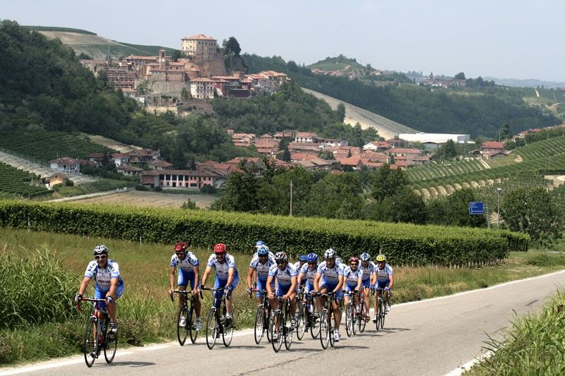
This route has been designed as a discovery trail through the most fascinating corners of the Roero region, an area probably less well known than its 'sister' hill region The Langa. But the Roero, as you will quickly realise, also has everything to offer the discerning tourist: great wine and food, beautiful and at times dramatic landscapes, and towns and villages steeped in history. The round route - which begins and ends in Canale - presents a well-balanced series of uphill and downhill sections, suitable for all fit amateur cyclists blessed with a fair amount of stamina. From Canale, one of the area's main towns, the road heads uphill towards Castellinaldo, which possesses a magnificent historical centre, and then descends to Priocca, with its 11th-century Romanesque church of San Vittore.
From here, it's on to Magliano Alfieri, with its castle and wonderful views over both the Rocche hills and, further in the distance, the Langa, home to so many magnificent wines. From here, there are several uphill and downhill sections in the direction of Neive, then on, uphill, to Castagnito and Guarene, with a total difference in altitude of around 200 metres. Guarene also possesses a truly magnificent castle. This area of the Roero is also a wine producing one, but the landscape is more varied than in other parts of the region owing to the presence of commercial fruit orchards.>br /< You will now pass by the village of Monticello d'Alba, which possesses another very handsome castle still owned by local nobility, and then continue towards Santa Vittoria where, if you have the time, there is a wonderful view to be enjoyed from the top of the medieval watchtower. From here, it will be possible a pleasant detour to the town of Bra, not too far, just on the edge of the Roero region. This little town is where the revolutionary food and wine movement Slow Food was founded and, if time allows, we advise a break here to sample some of the local veal sausage and maybe a glass or two of Arneis, a fruity white wine produced in the Roero and much appreciated as an aperitif.>br /< The tour continues through the Rocche area towards Sommariva Perno and Baldissero, where the cultivation of strawberries and other fruit is predominant. The 'Rocche del Roero' area is a nature reserve, protected by the Ecomuseum and the municipalities of Monteu Roero and Montaldo. The roads are flanked by densely wooded land that provides an excellent habitat for many wild animals and insects. Bee keeping is widely practised here and local honey has a reputation for excellence. White truffles can be found in the woods owing to the wide variety of trees and shrubs to be found here. The local natural history museum (Museo Naturalistico) in Vezza d'Alba is worth a visit to admire the collections of local flora and fauna. From here, the route returns to Canale, where, as a reward, we advise a trip to the local Regional 'Enoteca' (Winehouse) for some well-deserved wine tasting.


The proposed itinerary is a real tour to discover the Roero, the route is characterized by a discreet linear development with contained and well-distributed variations in altitude, a real hilly ups and downs suitable for cyclists who love the landscape and with a good training. The ride begins and ends in Canale , one of the most important urban centers in the area and immediately climbs to Castellinaldo , home to a magnificent medieval village, descends towards Priocca and reaches Magliano Alfieri , dominated by the silhouette of the castle and home to an excellent where it will be possible to take a break while admiring the profile of the fortresses and push your gaze to the Langa of great wines. The alternation of ascents and descents continues descending in the direction of Neive to go up again towards Castagnito and Guarene (total difference in height of 200 metres), where the silhouette of the castle of the same name which dominates the hill will slide by our side. The crossed area is known for the production of excellent quality wines, but unlike other parts of the territory it offers varied views and a differentiation of agricultural production thanks to the numerous orchards that will accompany the visitor like the embrace of an attentive landlord . After Monticello d'Alba with its castle and noble example of a Roerine stronghold and skirting Santa Vittoria (the panoramic point made up of the ancient medieval tower is not to be missed) you come close to the territory of Bra, the birthplace of the Slow Food movement and a treasure trove of important Baroque evidence . Deviating slightly from the route and reaching the inhabited center, it will be possible to treat the palate to a delicious break based on the well-known veal sausage accompanied by a glass of Arneis, a typical fruity white wine, the protagonist of aperitifs throughout Piedmont. The tour continues by immersing itself in the most authentic and characteristic nature of the Roerine fortresses in the direction of Sommariva Perno and Baldissero (known for the production of strawberries and fruit), to enter the area protected by the Rocche del Roero Ecomuseum with the territory of the municipalities of Monteu Roero and Montaldo . Around the road it will be possible to appreciate extraordinary wooded areas, capable of offering optimal habitats for the production of honey and the search for truffles thanks to the richness and variety of tree and flower species. Continuing the development of the ride, don't miss a visit to the Naturalistic Museum of Vezza d'Alba, a collection of the main examples of local flora and fauna. With one last effort you reach your destination, where in the center of Canale a visit to the Regional Wine Cellar certainly deserves attention to round off the journey through the suggestions of the green Roero.
Be careful as the route crosses a busy section in correspondence of the SS 231 between Baraccone and Sant’Antonio
Canale: Enoteca Regionale of Roero.
Magliano Alfieri: Castle of Magliano Alfieri – Landscape Museum – Plaster Ceiling Museum.
Guarene: Castle of Guarene, Civic Picture Gallery of Modern Art.
Corneliano d’Alba: Tower of Corneliano d’Alba.
Monticello d’Alba: Castle of Monticello d’Alba.
Santa Vittoria d’Alba: Medieval Tower of Santa Vittoria, “Gioachino Chiesa” Plaster Collection and Confraternity of San Francesco.
Bra: historical centre with the museums of the Sistema Museale Urbano (Bra museums network) and the Bicycle museum, the village of Pollenzo with the complex of Agenzia, the Church of San Vittore and the Wine Bank.
Sommariva Perno: Tavoletto Sanctuary.
Monteu Roero: Castle of Monteu Roero.
Vezza d’Alba: Naturalistic Museum of Roero.
Popularne wycieczki w okolicy
-
5,0
Castagnito - Oratory of the Holy Spirit
średniWędrówka 14,7 km -
Barolo Classic
ciężkiDroga rowerowa 50,0 km -
PRALORMO - Ring around the Lake of the Thorn
Jazda na rowerze 11,3 km -
Via dei Briganti | Stage 1 Cisterna d'Asti - Ferrere
światłoWędrówka 10,2 km -
Via dei Santi: Stage 1 San Martino Alfieri - Celle Enomondo Fraz. San Pancrazio
światłoWędrówka 6,93 km -
BTB - Bar To Bar - Stage 1: Alba - Treiso
średniWędrówka 16,1 km -
Via dei Santi | Variant 1A San Martino Alfieri - Bridge over the Tanaro
światłoWędrówka 2,82 km -
The Big Chestnut Path
światłoWędrówka 4,34 km -
From Langa to Monferrato | Variation 2B Coazzolo - Castelletto hamlet
światłoWędrówka 6,65 km -
On the tracks of the Masche (folklore witches)
światłoDroga rowerowa 39,7 km

Wędrówki i tropienie


Nie przegap ofert i inspiracji na następne wakacje
Twój adres e-mail została dodana do listy mailingowej.