


Circular hiking trail from Mammern on Lake Constance to the Neuburg ruins
On the idyllic circular hiking trail, you can leisurely explore nature. There are opportunities to stop for refreshments in Mammern. A barbecue area by the Neuburg ruins invites you to linger. Beautiful...
On the idyllic circular hiking trail, you can leisurely explore nature. There are opportunities to stop for refreshments in Mammern. A barbecue area by the Neuburg ruins invites you to linger. Beautiful views from the Neuburg ruins over the Lower Lake and towards Reichenau Island.

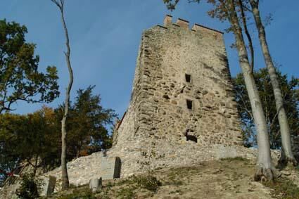

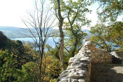

The circular hiking trail is signposted as a high trail from Mammern train station. On Liebenfelsstrasse, you cross the railway line and continue 200 meters south. Then a signpost leads off to the left away from the road. After crossing the village brook, you walk past orchards up to Klingenegg. Where the steep Seehaldenstrasse leads into the forest, the actual high trail begins on the left. On a varied hiking route that repeatedly offers magnificent views of the Lower Lake and the village of Mammern, you reach the Neuburg ruins after about two kilometers. On the way back, you pass the idyllic Neuburg pond. After crossing the main road, the path leads down to the railway underpass. Following the hiking trail westward, you return to the village of Mammern.
Tak
Good footwear, possibly a rain jacket
Access from Schaffhausen via Stein am Rhein or from Kreuzlingen via Steckborn.
Mammern can be easily reached by train or boat from Schaffhausen or Kreuzlingen.
Small paid parking at the train station
Take a short break on the way back at the lake restaurant Guldifuss.
Popularne wycieczki w okolicy
-
4,0
Around the island of Reichenau
światłoWędrówka 10,9 km -
5,0
Mindelsee-Runde
światłoWędrówka 7,83 km -
Hike on the panorama route of the Höri Peninsula
średniWędrówka 8,11 km -
4,0
Circular hike Gaienhofen-Middle Höri
średniWędrówka 12,6 km -
3,7
Firstweg Langenmos
średniWędrówka 5,76 km -
Stein am Rhein - Hohenklingen Castle - Stein am Rhein
ciężkiWędrówka 7,79 km -
Rundweg Mindelsee
średniWędrówka 13,3 km -
5,0
From Konstanz around the island of Reichenau (Lake Constance)
średniJazda na rowerze 28,7 km -
SchweizMobil 2: Rhine Route stage 6 (Kreuzlingen - Schaffhausen)
średniJazda na rowerze 47,0 km -
Rundweg Schienerberg
ciężkiWędrówka 18,6 km
Wędrówki i tropienie


Nie przegap ofert i inspiracji na następne wakacje
Twój adres e-mail została dodana do listy mailingowej.