


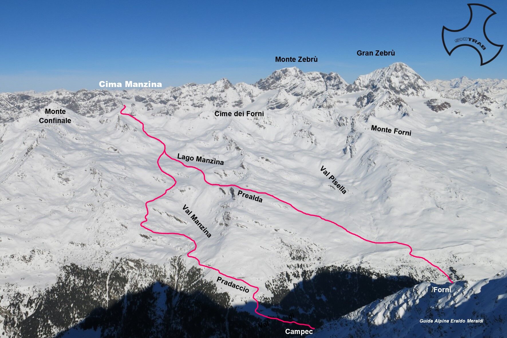
Cima Manzina
From the Campec locality in the Forni valley, near the Stella Alpina refuge, start climbing following the mule track that leads to the Pradaccio di Sotto huts and arrived coming out of the edge of the...
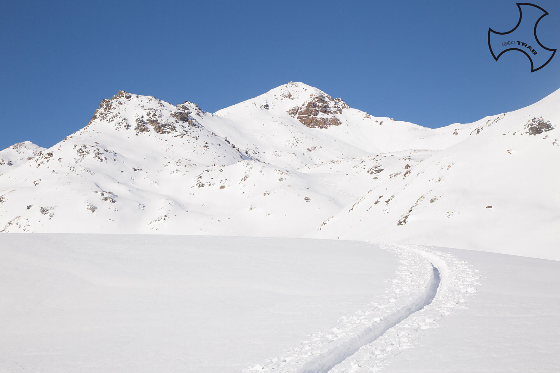
From the Campec locality in the Forni valley, near the Stella Alpina refuge, start climbing following the mule track that leads to the Pradaccio di Sotto huts and arrived coming out of the edge of the forest continue to the Pradaccio di Sopra huts. Continue to the left entering the Manzina valley and go up a small valley to the left of the obvious furrow where the Manzina stream descends, arriving then in a wide flat area; this point can also be reached starting from the Forni and going up above the Forni hut and after overcoming the first steep section you arrive on a short plateau that then enters the Pisella valley, from here you gradually climb towards the Prealda rock on the left. From here or losing a few meters of elevation gain, you arrive just below Manzina Lake, which you reach by bending diagonally to the left. Now continue in a northerly direction climbing along a wide gully to another flat area. Then along a steep slope to the right following a faint ridge below some small rocks. From here diagonally to the left until you reach the last section of ridge leading to the summit.

Berni Refuge, Dosegu' Glacier, Punta San Matteo.
Self-rescue equipment (ARTVA, shovel and probe). Rampant.
The route description and trail are approximate and should be verified on site depending on the condition of the snowpack present during the hike.
Because this is a hike in a snowy mountain environment at high altitudes subject to continually changing snowpack conditions, it is advisable to have adequate experience in ski mountaineering, knowledge of the area, and up-to-date information on snow conditions.
Accompaniment with a professional guide is recommended.
In the vicinity of the Edelweiss refreshment stand.
The route description and trail are approximate and should be verified on site depending on the condition of the snowpack present during the hike.
Because this is a hike in a snowy mountain environment at high altitudes subject to continually changing snowpack conditions, it is advisable to have adequate experience in ski mountaineering, knowledge of the area, and up-to-date information on snow conditions.
Accompaniment with a professional guide is recommended.
Popularne wycieczki w okolicy
- 3,7
Payerhütte 3020m
Wędrówka 6,98 km - 3,7
Düsseldorfer Hütte 2721m
średniWędrówka 4,14 km - 5,0
Martell-Tal Rundweg zur Marteller Hütte
światłoWędrówka 10,8 km - 4,8
Martellerhütte Höhenweg
średniWycieczka wysokogórska 8,70 km - 3,7
Von Sulden zur Hinteren Schöntaufspitze
średniWędrówka 12,7 km - 4,9
Plimaschlucht
światłoWycieczki górskie 7,23 km - 4,3
Sonnenaufgang auf der Rötelspitze im Nationalpark Stilfserjoch
Wędrówka 2,02 km - 4,5
Obervinschgau - Madritschjoch, der höchste Transalp Übergang
Mountainbike 9,54 km Wanderung/Aufstieg zur Payerhütte
światłoWędrówka 15,9 km- 4,0
Tschengelser Hochwand Stelvio, Trentino-Alto Adige
średniVia ferrata 14,3 km

Wędrówki i tropienie


Nie przegap ofert i inspiracji na następne wakacje
Twój adres e-mail została dodana do listy mailingowej.