


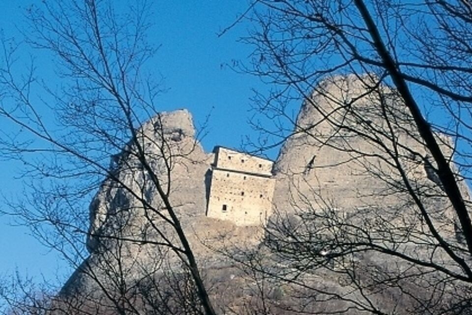
GE_18 Vobbia – Castello della Pietra
from Vobbia (475 m) follow the mule track which takes north-bound to the little hamlet of Torre (490 m). Here you take a subway between the houses and go down for 50 metres until you find the beginning...
from Vobbia (475 m) follow the mule track which takes north-bound to the little hamlet of Torre (490 m). Here you take a subway between the houses and go down for 50 metres until you find the beginning of the pathway to the right, indicated by a panel of the Ente Parco Antola. The path rises parallel to the Crèuze brook and then turns left, developing almost level. The first stop is located at Poggetto, panoramic point of view on the village and its valley. The second stop shows an ancient secchereccio (or abergu), a little rural building which in the past was used to dry the chestnuts. Further on at the third stop you can observe an old charcoal pit. The fourth stop shows us the conglomeratic rock, made up of pebbles of different sizes. After the point of view on the canyon of the Vobbia Stream (stop number five) the path descends through a mixed woodland (stop number six) crossing the Campo Brook in a wet area rich in ferns (stop number seven). After the brook, the path turns left through increasingly scattered trees which are soon replaced by the conglomeratic rock and rock plants. The pinnacles of the Castello della Pietra are above us: walking on through a rocky terrace where the path is secured by a railing you can reach the access stair to the Castello della Pietra (580 m; 2 hours) If you don't want to go back by the same itinerary you can go down by the comfortable access path to the castle which leads to the road between Isola del Cantone and Vobbia in 15 minutes. Following this road towards left it is possible to go back to Vobbia after 3 km of level walk.

At the first roundabout after Busalla motorway exit (A7 Milano – Genova motorway) turn left till the second roundabout where you turn right. After the bridge on the Scrivia river drive along the Seminella Valley all the way up to Crocefieschi, where you turn left to go down to Vobbia or from Isola del Cantone motorway exit (A7 Milano-Genova motorway) you turn right to Vobbia.
Nature and Landscape * * * * * Family * * * * Gourmet * * * Culture * * * * * *
Popularne wycieczki w okolicy
Sentiero 200 - Anello Borbera - Spinti - TAPPA 7/11 (Capanne di Carrega - Monte Antola) in camminata
Trasa pielgrzymki 6,23 kmSentiero 200 - Anello Borbera - Spinti - TAPPA 7/11 (Capanne di Carrega - Monte Antola) in mountain bike
Mountainbike 6,23 kmSentiero 200 - Anello Borbera - Spinti - TAPPA 8/11 (San Fermo - Monte Antola) in camminata
Trasa pielgrzymki 7,75 kmSentiero 200 - Anello Borbera - Spinti - TAPPA 8/11 (San Fermo - Monte Antola) in mountain bike
Mountainbike 7,75 kmSentiero Vignole Borbera - Roccaforte Ligure - sentiero 275 in camminata
Trasa pielgrzymki 16,8 kmSentiero 200 - Anello Borbera - Spinti - TAPPA 6/11 (Capanne di Cosola - Capanne di Carrega) in camminata
Trasa pielgrzymki 9,40 kmSentiero 200 - Anello Borbera - Spinti - TAPPA 11/11 (Borassi - Arquata Scrivia) in camminata
Trasa pielgrzymki 16,7 kmSentiero Vignole Borbera - Roccaforte Ligure - sentiero 275 in mountain bike
Mountainbike 16,8 kmSentiero 200 - Anello Borbera - Spinti - TAPPA 10/11 (Costa Salata Mongiardino - Borassi) in mountain bike
Mountainbike 7,21 kmSentiero 200 - Anello Borbera - Spinti - TAPPA 10/11 (Costa Salata Mongiardino - Borassi) in camminata
Trasa pielgrzymki 7,21 km
Wędrówki i tropienie


Nie przegap ofert i inspiracji na następne wakacje
Twój adres e-mail została dodana do listy mailingowej.