Nawigacja
Pobierz tę trasę na swój telefon komórkowy
Mapa
The Loire by Bike from Nantes to Angers
światło
Kolarstwo długodystansowe
107,70 km
Zeskanuj kod QR i rozpocznij nawigację w aplikacji bergfex.
QR Code
Wędrówki i tropienie
Pobierz dla iOS
Pobierz dla systemu Android

The Loire by Bike from Nantes to Angers

światło
Kolarstwo długodystansowe
Odległość
107,70 km
Czas trwania
07:45 h
Ascent
126 hm
Poziom morza
2 - 56 m
Ścieżka do pobrania
Mapa
The Loire by Bike from Nantes to Angers
światło
Kolarstwo długodystansowe
107,70 km

Ride through the Loire Valley for 100km from Nantes to Angers. Easy to travel with the family, as a couple, or with friends, this part of the La Loire Vélo itinerary offers visitors a unique experience....

Opis

Ride through the Loire Valley for 100km from Nantes to Angers. Easy to travel with the family, as a couple, or with friends, this part of the La Loire Vélo itinerary offers visitors a unique experience. Numerous natural landscapes, picturesque towns and villages, and panoramic views overlooking the Loire Valley await you.

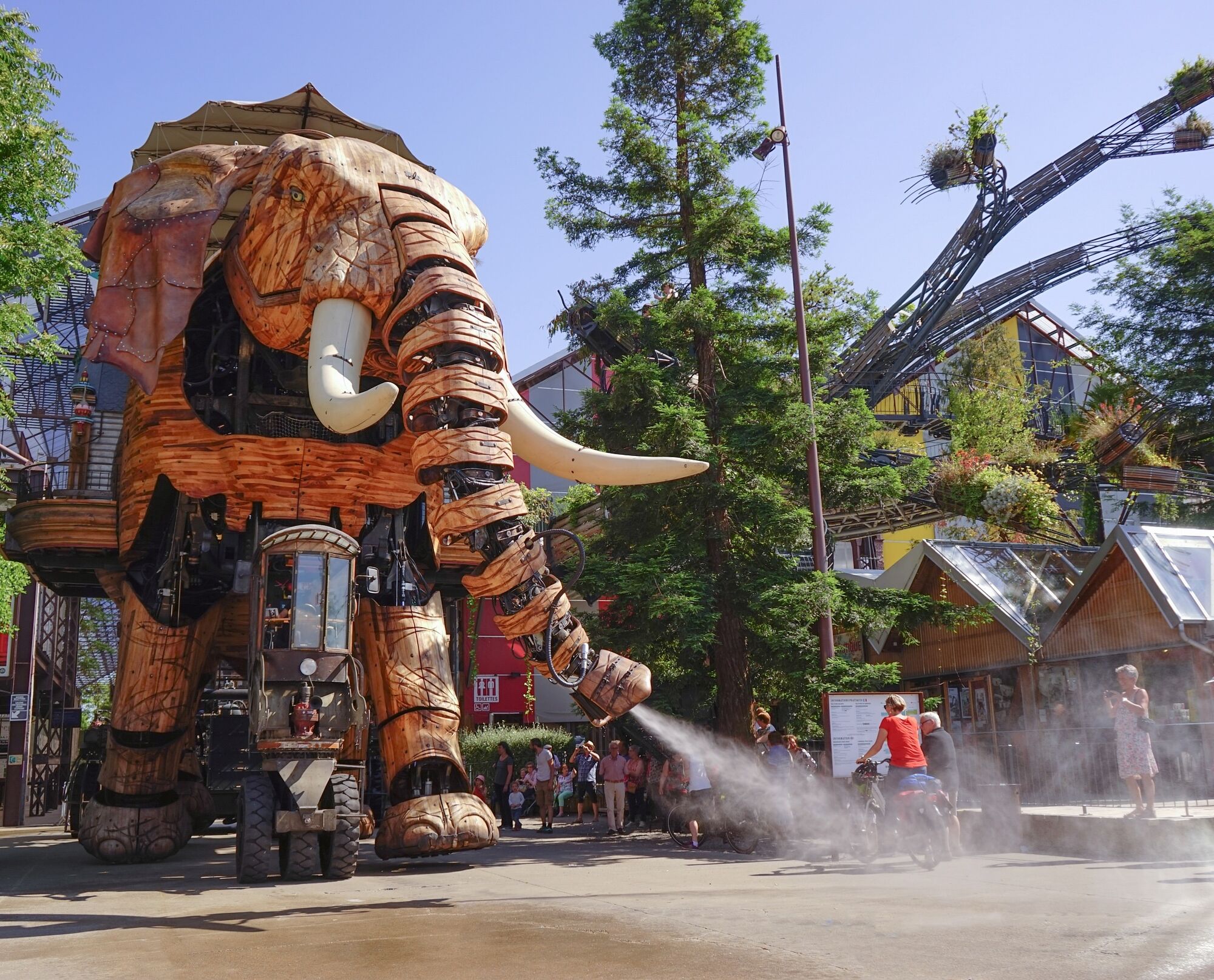
Start with Nantes and its industrial heritage with the Machines de l'Ile, then head off in the direction of the fishing villages classified as "Petite Cité de Caractère".

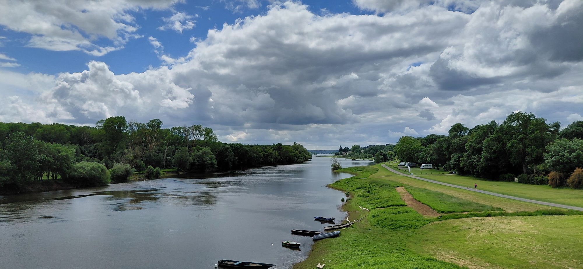
Make a stop in Champtoceaux and board the boat "La Luce" for a river cruise. Ride to Saint-Florent-le-Vieil and admire the panorama from Mont Glonne.

Take time to sample the local specialties at the guinguette "Le Tourbillon" in La Possonniere, one of the oldest in Anjou.

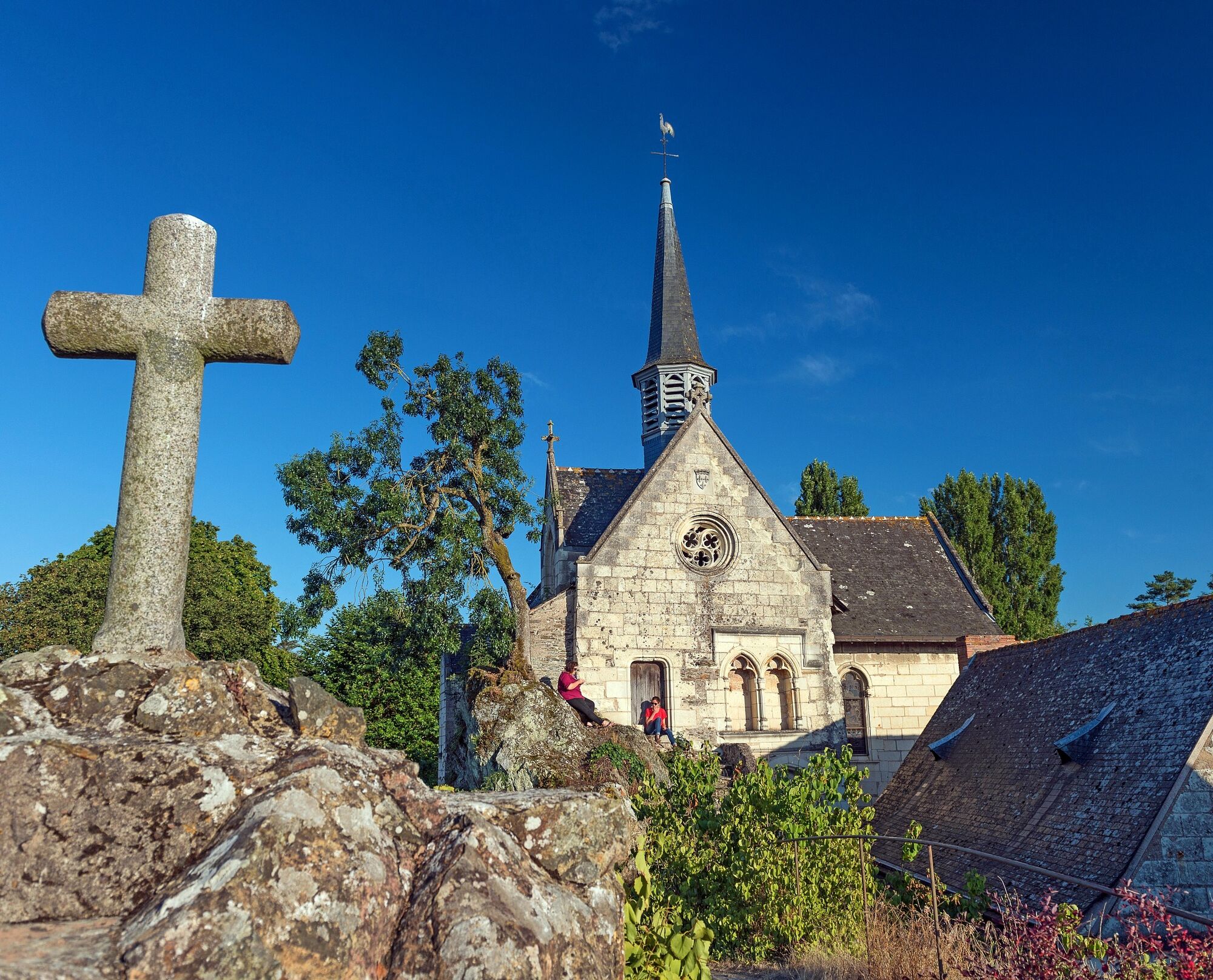
Continue towards the charming Ile de Béhuard. You'll have the opportunity to discover the church of Notre Dame de Béhuard, which is encrusted on a rock and is the only part of the island that is not subject to flooding.

Tour the Ile de Béhuard, one of the oldest islands in Anjou.

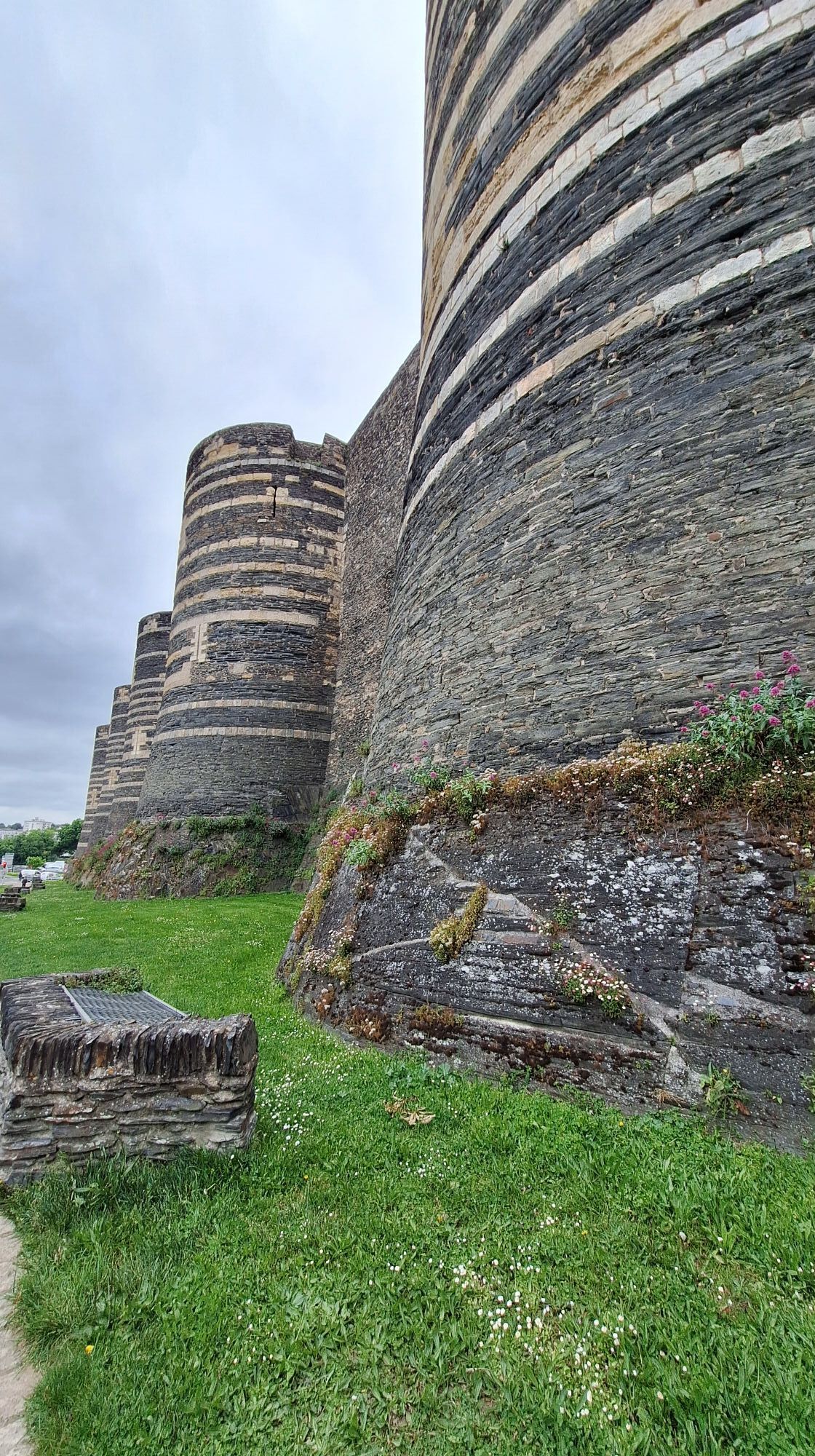
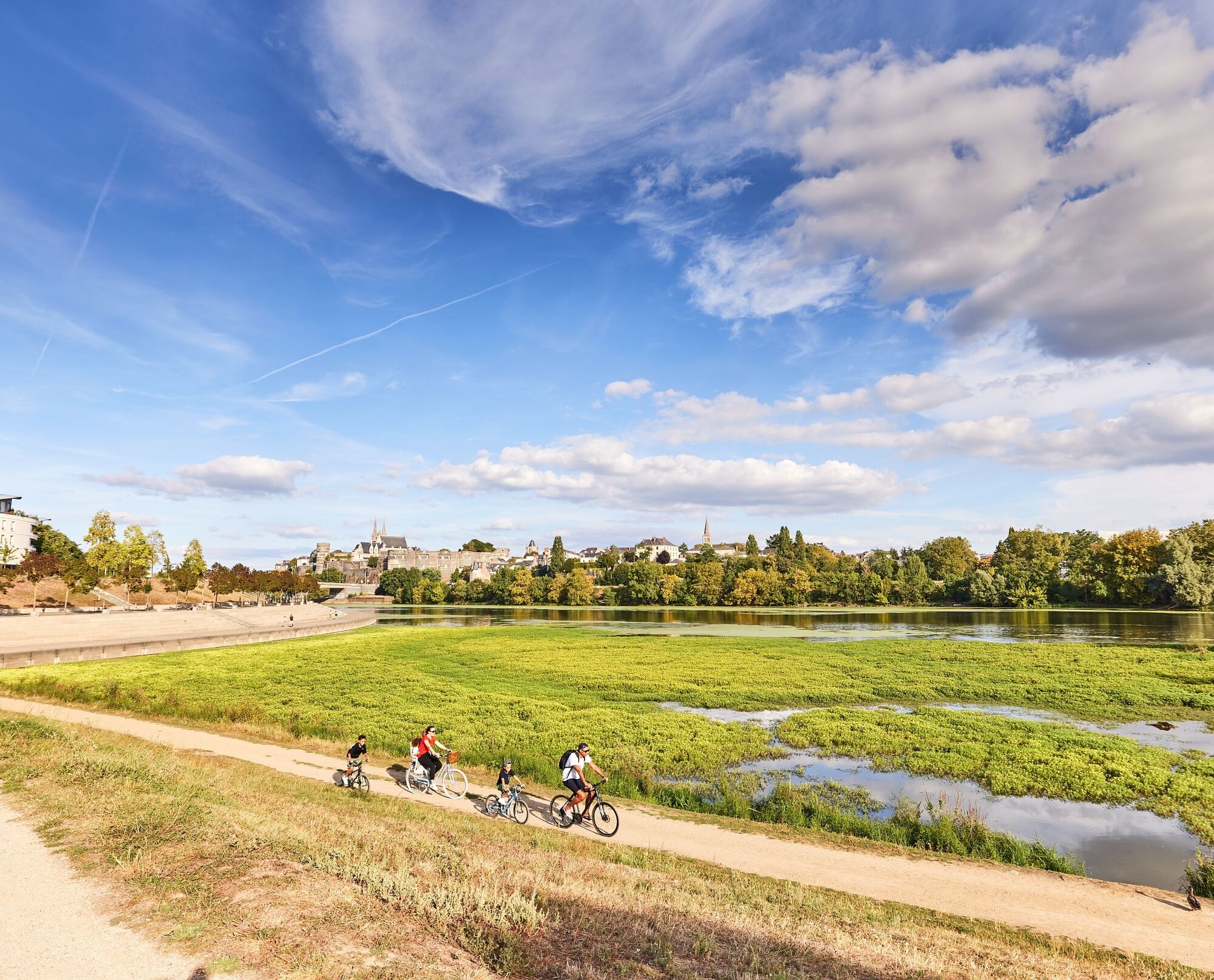
End your tour at the château d'Angers. The tapestry of the Apocalypse and its 17 defensive towers will not fail to amaze you.

 
Trasa
Nantes
(12 m)
Miasto
0,1 km
Boire Courant
(5 m)
Wioska
12,1 km
Chapelle de la Bridonnière
(23 m)
Miejsce kultu
28,8 km
Ancenis
(18 m)
Miasto
41,1 km
Église Notre-Dame
(16 m)
Miejsce kultu
63,8 km
Église Saint-Pierre-et-Saint-Romain
(26 m)
Miejsce kultu
90,4 km
Angers
(22 m)
Miasto
107,6 km
Trasa
Mapa
The Loire by Bike from Nantes to Angers
światło
Kolarstwo długodystansowe
107,70 km
Cathédrale
(17 m)
Sąsiedztwo
0,0 km
Nantes
(12 m)
Miasto
0,1 km
Pont Morand
(8 m)
Sąsiedztwo
0,3 km
Bretagne
(21 m)
Sąsiedztwo
0,6 km
Decré
(11 m)
Sąsiedztwo
0,9 km
Bouffay
(8 m)
Sąsiedztwo
1,0 km
Feydeau
(7 m)
Sąsiedztwo
1,1 km
Madeleine
(7 m)
Sąsiedztwo
1,5 km
Les Ponts
(5 m)
Sąsiedztwo
1,9 km
Rezé
(14 m)
Miasto
1,9 km
Vieux Malakoff
(6 m)
Sąsiedztwo
2,9 km
Église Saint-Marc de Malakoff
(8 m)
Miejsce kultu
3,7 km
Malakoff
(8 m)
Sąsiedztwo
3,9 km
Saint-Sébastien-sur-Loire
(22 m)
Miasto
5,7 km
La table des bons vivants
(6 m)
Restauracja
8,2 km
Bellevue
(6 m)
Wioska
8,5 km
Sainte-Luce-sur-Loire
(15 m)
Miasto
8,7 km
Villa Mon Rêve
(5 m)
Restauracja
9,9 km
Boire Courant
(5 m)
Wioska
12,1 km
La Guenetrie
(6 m)
Rozliczenie
12,7 km
La Divate
(8 m)
Restauracja
12,8 km
Les Carroueils
(6 m)
Rozliczenie
13,4 km
Auberge Nantaise
(8 m)
Restauracja
14,2 km
Le Bout des Ponts
(7 m)
Wioska
14,4 km
Le Ruaud
(6 m)
Rozliczenie
14,7 km
Beauvais
(7 m)
Rozliczenie
14,8 km
La Praudière
(7 m)
Rozliczenie
14,9 km
La Chebuette
(6 m)
Wioska
15,7 km
La Cale
(7 m)
Restauracja
16,2 km
Le Chaussin Rioux
(7 m)
Rozliczenie
17,9 km
Ouches
(7 m)
Rozliczenie
18,0 km
Les Mottes
(6 m)
Rozliczenie
18,0 km
La Pierre Percée
(6 m)
Rozliczenie
18,2 km
La Degondelle
(6 m)
Rozliczenie
18,2 km
La Grimaudière
(7 m)
Rozliczenie
18,2 km
La Pierre Percée
(7 m)
Restauracja
18,7 km
Vieilles Maisons
(7 m)
Rozliczenie
18,8 km
Les Levées
(6 m)
Rozliczenie
18,9 km
La Pilardière
(6 m)
Rozliczenie
19,2 km
Chapelle Saint-Simon
(8 m)
Miejsce kultu
19,8 km
L'Aireau
(7 m)
Rozliczenie
23,5 km
Les Grenettes
(19 m)
Rozliczenie
24,8 km
La Cave
(10 m)
Rozliczenie
25,6 km
Le Tertre
(21 m)
Rozliczenie
25,8 km
Les Basses-Sauzaies
(11 m)
Rozliczenie
25,9 km
Chapelle de la Bridonnière
(23 m)
Miejsce kultu
28,8 km
La Rivière
(12 m)
Rozliczenie
30,9 km
Le Cul du Moulin
(10 m)
Rozliczenie
31,2 km
Oudon
(15 m)
Wioska
32,4 km
Le Petit Paris
(9 m)
Korytarz/teren
32,7 km
La Carterie
(44 m)
Rozliczenie
33,9 km
Mont-Piron
(11 m)
Rozliczenie
34,9 km
Vauvressix
(10 m)
Rozliczenie
36,2 km
La Bigoterie
(10 m)
Rozliczenie
39,3 km
Village Brébion
(11 m)
Rozliczenie
39,5 km
Le Champ Roncin
(11 m)
Rozliczenie
39,8 km
Le Tertre
(11 m)
Rozliczenie
40,1 km
Ancenis
(18 m)
Miasto
41,1 km
Le Château
(16 m)
Sąsiedztwo
41,5 km
La Goutte
(10 m)
Rozliczenie
42,7 km
Le Planty
(14 m)
Rozliczenie
43,0 km
Bel Air
(27 m)
Rozliczenie
43,1 km
La P'tite Auberge
(14 m)
Restauracja
43,1 km
Le Moulin de Juigné
(31 m)
Rozliczenie
43,2 km
Juigné
(25 m)
Rozliczenie
43,4 km
Le Bernardeau
(11 m)
Rozliczenie
44,4 km
La Basse Boire
(12 m)
Rozliczenie
46,0 km
La Grée du Pâtis
(15 m)
Rozliczenie
46,2 km
Le Rocher
(13 m)
Rozliczenie
46,3 km
La Cave
(12 m)
Rozliczenie
46,5 km
La Chaussée
(11 m)
Rozliczenie
48,3 km
Les Cosniers
(11 m)
Rozliczenie
49,4 km
La Bimboire
(10 m)
Rozliczenie
50,2 km
La Rougeauderie
(11 m)
Rozliczenie
50,6 km
La Belle Croix
(10 m)
Rozliczenie
50,8 km
Bréluce
(10 m)
Rozliczenie
51,1 km
Le Bois Vert
(12 m)
Rozliczenie
51,8 km
La Meilleraie
(13 m)
Rozliczenie
54,5 km
Le Fresne-sur-Loire
(27 m)
Wioska
62,9 km
La Cale
(15 m)
Restauracja
63,5 km
Crêperie La Galerie
(15 m)
Restauracja
63,8 km
Église Notre-Dame
(16 m)
Miejsce kultu
63,8 km
Ingrandes
(19 m)
Wioska
63,9 km
La Route du Sel
(16 m)
Restauracja
63,9 km
Montjean-sur-Loire
(31 m)
Wioska
68,9 km
La Basse Île
(16 m)
Rozliczenie
74,0 km
Chalonnes-sur-Loire
(23 m)
Wioska
78,3 km
Guinguette Les Tourbillons
(16 m)
Restauracja
87,2 km
La Possonnière
(35 m)
Wioska
87,6 km
Landeronde
(24 m)
Rozliczenie
87,7 km
Piano Piano
(29 m)
Restauracja
87,7 km
Le Bourg
(32 m)
Rozliczenie
87,8 km
Église Saint-Jacques
(34 m)
Miejsce kultu
87,8 km
La Perrière
(46 m)
Rozliczenie
87,9 km
Clos du Moulin
(54 m)
Rozliczenie
88,0 km
Bellevue
(49 m)
Korytarz/teren
89,0 km
L'Aiglerie
(48 m)
Korytarz/teren
89,2 km
Les Complants
(38 m)
Korytarz/teren
90,2 km
Église Saint-Pierre-et-Saint-Romain
(26 m)
Miejsce kultu
90,4 km
Le Chenin
(27 m)
Restauracja
90,4 km
Savennières
(27 m)
Wioska
90,5 km
Les Terrasses
(18 m)
Korytarz/teren
92,7 km
La Pierre Bécherelle
(15 m)
Korytarz/teren
93,7 km
Bois de la Grotte
(43 m)
Korytarz/teren
94,3 km
Épiré
(57 m)
Wioska
94,5 km
La Treille
(45 m)
Korytarz/teren
94,5 km
La Croix Picot
(57 m)
Rozliczenie
95,1 km
Chantourteau
(18 m)
Rozliczenie
95,6 km
La Pointe
(39 m)
Wioska
95,7 km
Café des piplettes
(19 m)
Restauracja
96,2 km
Monkey
(18 m)
Restauracja
96,2 km
L'Ancre de marine
(19 m)
Restauracja
96,2 km
Bouchemaine
(32 m)
Wioska
98,2 km
Le Haras
(47 m)
Sąsiedztwo
106,9 km
Angers
(22 m)
Miasto
107,6 km
Informacje o wycieczce

Enjoy a weekend of cycling along the Loire, discovering picturesque villages, wild nature and two lively towns.

Technologia
1 / 6
Stan
2 / 6
Krajobraz
n.d.
Doświadczenie
n.d.
Dostępny przez cały rok
Sty
Lut
Mar
Kwi
Maj
Cze
Lip
Sie
Wrz
Paź
Lis
Gru
Udostępnij trasę
Mapa
The Loire by Bike from Nantes to Angers
światło
Kolarstwo długodystansowe
107,70 km
Błąd
Wystąpił błąd. Spróbuj ponownie.
Informacje o trasie
Trasa

The finest panoramic views of the Loire:

From the Belvédère de l'Hermitage à Nantes, From the Jardins du Champalud à Champtoceaux, From  the esplanade of Saint-Florent-le-Vieil Abbey on Mont-Glonne.
Sprzęt

Take a bike that's in good condition and well equipped: comfortable saddle, lighting, luggage rack, inflated tires, brakes, horn, repair kit, anti-theft device, panniers...

How do you prepare? What equipment should you bring? Find all our advice on the Loire à Vélo website: www.loireavelo.fr/pratique/conseils-pour-organiser-son-voyage/

Instrukcje bezpieczeństwa

Find all the information you need on safety rules and how to equip your vehicle on the Sécurité Routière website: www.securite-routiere.gouv.fr/reglementation-liee-aux-modes-de-deplacements/velo/equipements-obligatoires-velo 

Fire brigade: 112 from a mobile or 18 from a landline

Gendarmerie: 17  

Samu : 15

Informacje o przyjeździe
Przybycie

Think about carpooling

Transport publiczny

By train :

Nantes and Angers TGV stations

TER regional trains: www.ter.sncf.com/pays-de-la-loire/services-contacts/ter-velo

Loire à Vélo train: www.loireavelo.fr/se-deplacer-sur-litineraire/le-train-velo-loire

By car :

Paris / Angers : 3h

Paris / Nantes : 4h

Bordeaux / Angers : 4h

Bordeaux / Nantes : 3h30

Caen / Angers : 2h20

Caen / Nantes : 3h

Parking

Parking in Nantes and Angers: www.loireavelo.fr/services-velo/parkings-voitures-longue-duree

Contact the local Tourist Offices for advice.

Dodatkowe informacje i wskazówki
Dodatkowe informacje

Remember to come by train and rent your bike locally. Rent your bike in Nantes and drop it off in Angers: www.loireavelo.fr/services-velo/location-de-velo-en-itinerance

Consider the Accueil Vélo network for your accommodation, of which there are many along the route: www.loireavelo.fr/hebergements

To organize your trip and stopovers, visit the La Loire à Vélo website: www.loireavelo.fr

Wskazówki

This is a 3-day/2-night tour for beginners, families, couples and friends. For more information, visit www.loireavelo.fr.

Wędrówki i tropienie

Wędrówki i tropienie

Pobierz dla iOSPobierz dla systemu Android
Wędrówki i tropienie
Ponad 550.000 propozycji wycieczek, szczegółowe mapy i intuicyjny planer tras sprawiają, że aplikacja jest niezbędna dla wszystkich entuzjastów przyrody.
bergfex