Autour de Brancion
średni
Nawigacja
Nawigacja
Pobierz tę trasę na swój telefon komórkowy
Autour de Brancion
średni
Wędrówka
11,12
km
Zeskanuj kod QR i rozpocznij nawigację w aplikacji bergfex.

Wędrówki i tropienie


Autour de Brancion
średni
Odległość
11,12
km
Czas trwania
03:10
h
Ascent
260
hm
Poziom morza
210 -
406
m
Ścieżka do pobrania
Autour de Brancion
średni
Wędrówka
11,12
km
Take a step back in time and immerse yourself in the authenticity of southern Burgundy with an unforgettable hike around Brancion, listed as one of France's "most beautiful detours"! From the very first...
Opis
Take a step back in time and immerse yourself in the authenticity of southern Burgundy with an unforgettable hike around Brancion, listed as one of France's "most beautiful detours"! From the very first steps, you'll be transported to a bucolic setting where nature meets history, and where every step is an invitation to contemplate and marvel.
Trasa
Mollard
(303 m)
Rozliczenie
1,7 km
Martailly-lès-Brancion
(291 m)
Wioska
1,8 km
L'Échelette
(344 m)
Rozliczenie
3,7 km
Église paroissiale Notre-Dame de l'Assomption
(273 m)
Miejsce kultu
9,6 km
Sandwicherie les G
(374 m)
Restauracja
10,7 km
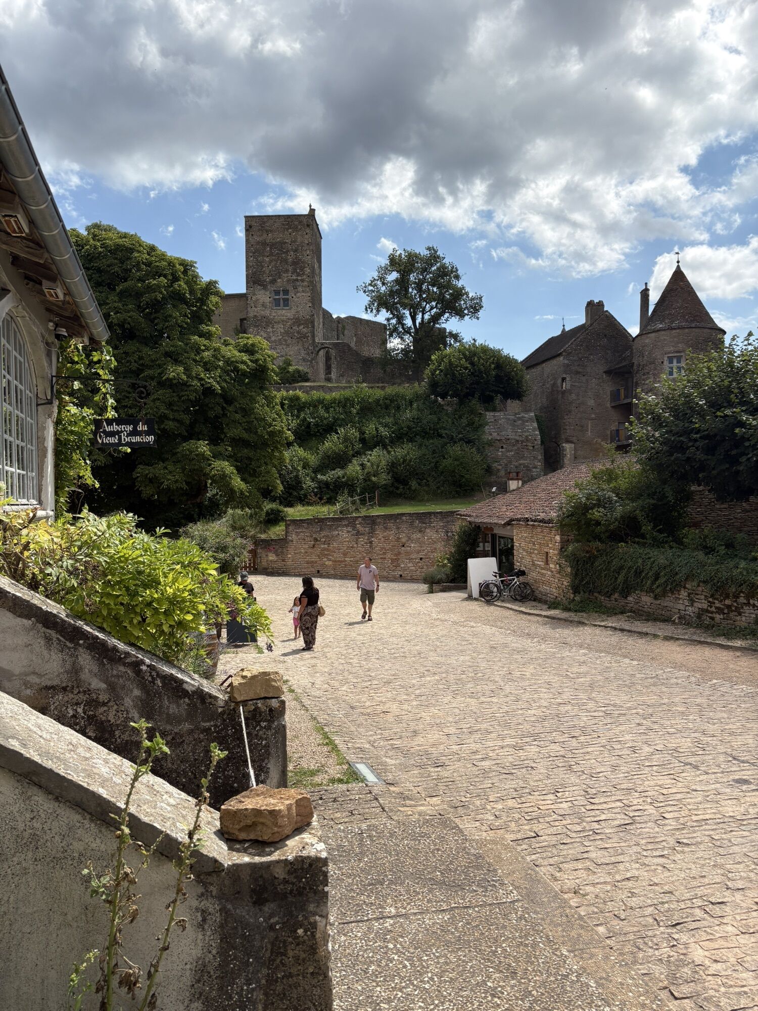
Auberge du Vieux Brancion
(370 m)
Restauracja
10,8 km
Trasa
Autour de Brancion
średni
Wędrówka
11,12
km
Col de Brancion
(355 m)
Korytarz/teren
0,4 km
Mollard
(303 m)
Rozliczenie
1,7 km
Martailly-lès-Brancion
(291 m)
Wioska
1,8 km
Le Biat
(309 m)
Rozliczenie
2,3 km
L'Échelette
(344 m)
Rozliczenie
3,7 km
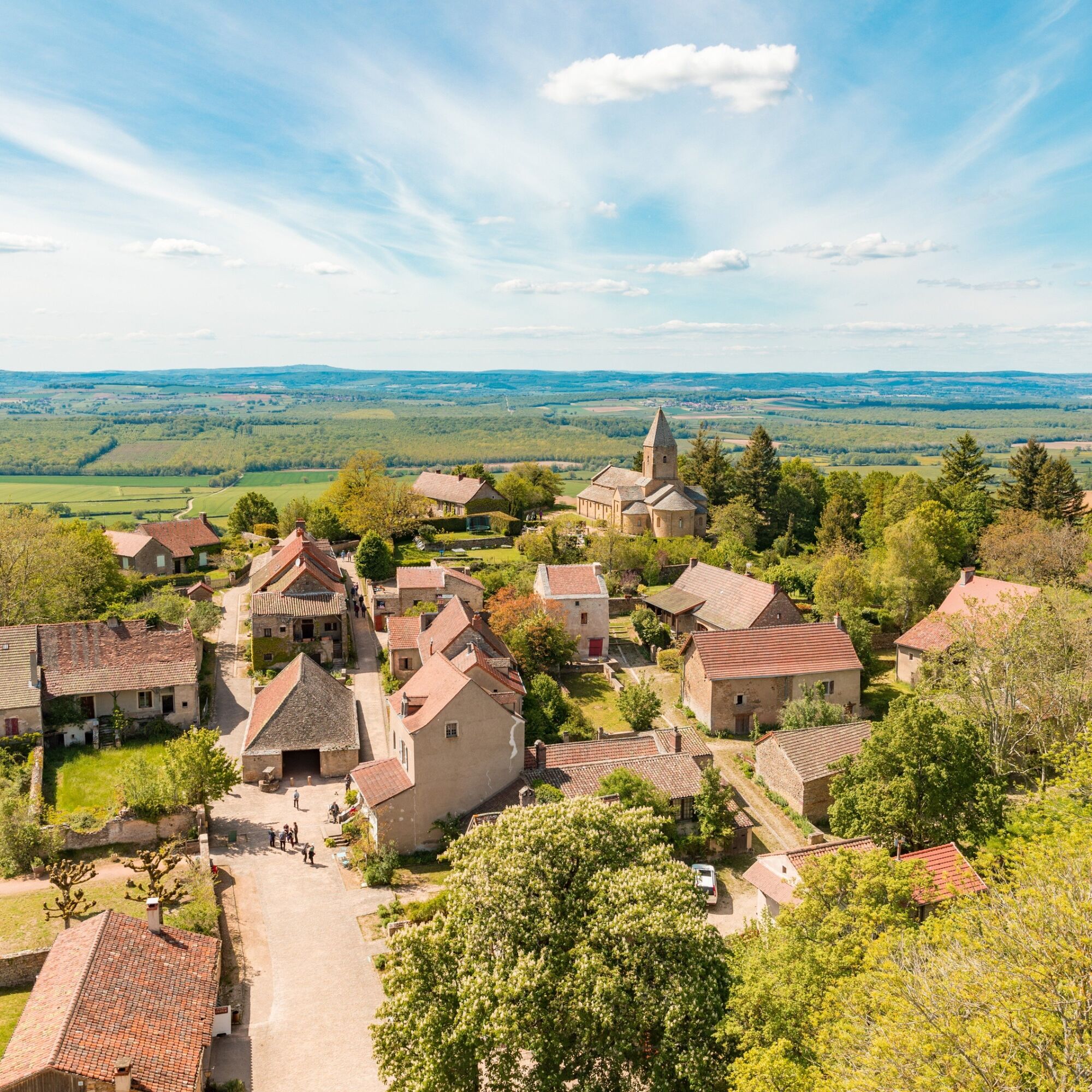
La Chapelle-sous-Brancion
(271 m)
Wioska
9,6 km
Église paroissiale Notre-Dame de l'Assomption
(273 m)
Miejsce kultu
9,6 km
Brancion
(371 m)
Rozliczenie
10,7 km
Sandwicherie les G
(374 m)
Restauracja
10,7 km
Auberge du Vieux Brancion
(370 m)
Restauracja
10,8 km
Autor
Dostarczone przez Mission Tourisme du Département de Saône-et-Loire
Wycieczkę Autour de Brancion zapewnia outdooractive.com.
Instrukcje bezpieczeństwa
In case of emergency, dial 112
Informacje o przyjeździe
Przybycie
Consider carpooling
Parking
Parking near the starting point
Dodatkowe informacje i wskazówki
Dodatkowe informacje
TOURNUS â OT Mâconnais-Tournugeois â Cat.II http://www.tournus-tourisme.com
Nie ma jeszcze recenzji
Popularne wycieczki w okolicy
La Boucle de Bourgogne du Sud
światłoJazda na rowerze 145,0 kmLe chemin des Moines
średniWędrówka 35,0 kmCycloRoute71 - Etape 2 de Cormatin à Tournus
średniJazda na rowerze 31,1 kmLa Voie Bleue, Moselle-Saône à vélo : de Mont-les-Seurre à Mâcon
światłoJazda na rowerze 212,4 kmCycloRoute71 - Etape 1 de Mâcon à Cormatin
średniJazda na rowerze 51,1 kmBoucle "Vélo & Fromages"
światłoJazda na rowerze 322,2 kmLe Marais de Massilly
światłoWędrówka 0,20 kmLes crêtes boisées du Mâconnais
średniMountainbike 170,8 kmDu toit des grottes à la Mouge
światłoWędrówka 1,25 kmLes quatre vents
średniJazda konna 17,4 km

Wędrówki i tropienie

Ponad 550.000 propozycji wycieczek, szczegółowe mapy i intuicyjny planer tras sprawiają, że aplikacja jest niezbędna dla wszystkich entuzjastów przyrody.

Nie przegap ofert i inspiracji na następne wakacje
Zapisz się do newslettera
Błąd
Wystąpił błąd. Spróbuj ponownie.Dziękujemy za rejestrację
Twój adres e-mail została dodana do listy mailingowej.
Wycieczki po całej Europie
Austria Szwajcaria Niemcy Włochy Słowenię Francja Holandia Belgia Polska Liechtenstein Czechy Słowacja Hiszpania Chorwacja Bośnia i Hercegowina Luksemburg Andorra Portugalia Islandia Wielka Brytania Irlandia Grecja Albania Macedonia Północna Malta Norwegia Czarnogóra Mołdawia Kosowo Węgry San Marino Rumunia Estonia Łotwa Białoruś Cypr Litwa Serbia Bułgaria Monako Dania Szwecja Finlandia