


TIP Trip Tirol ➤ the Riedberg Panorama Road
Poziom trudności: 1
💚 Along the Schönberger Ache, the route winds westward through Obermaiselstein and climbs uphill.💚 The only hairpin of the pass is found at its summit near the Grasgehren Hut, also popular with bikers....
ð Along the Schönberger Ache, the route winds westward through Obermaiselstein and climbs uphill.ð The only hairpin of the pass is found at its summit near the Grasgehren Hut, also popular with bikers. Shortly after Schlipfhalden, the road crosses the border into Austria and gently descends through the foothills of the Bregenz Forest.
ð The Sturmannshöhle near Obermaiselstein is the only show cave open to visitors in the Allgäu. It is located about 980 meters high at the foot of the Ochsenberg, in an impressive rock crevice washed out by water. Follow the mystical stories and tales down nearly 200 steps about 300 meters deep into the fascinating world of prehistory. Rock formations 120 million years old accompany you on the way to the "Dragon's Gate." The Sturmannshöhle is easy to explore with sturdy footwear, and all information is available at the Obermaiselstein "Haus des Gastes."

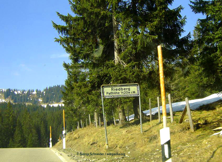
ð The highest inner-German mountain pass cheats a little when it comes to its exact height. A sign at the summit indicates 1,420 meters, but the actual height is "only" 1,407 meters. The eastern ramp from Obermaiselstein impresses with its swirl of curves, while the western ramp towards Balderschwang allows for smooth riding with its route layout. Gradients of up to 16 percent add to making the crossing worthwhile.
Tak
Tak
Motorcycle: ⤠motorcycle helmet ⤠motorcycle gloves ⤠motorcycle boots ⤠motorcycle jacket and pants
Convertible: ⤠baseball cap ⤠sunscreen ⤠sunglasses ⤠convertible ?!?!
watch the road surface
Let's head to Balderschwang and turn off the B19 onto the road up to the pass. Along the Schönberger Ache, the route winds westward through Obermaiselstein and climbs uphill. The only hairpin of the pass is found at its summit near the Grasgehren Hut, popular among bikers. Shortly after Schlipfhalden, the road crosses the border into Austria and gently descends through the foothills of the Bregenz Forest.
Better with convertible or motorcycle
ample parking available
Vacation in Tyrol â search & book
1
toll-free
The eastern ramp from Obermaiselstein convinces with curves, the western ramp to Balderschwang allows for smooth riding with its route layout.
Kamery internetowe z trasy
Hochgratbahn Bergstation
Obermaiselstein
Fischen im Allgäu
Hörnerbahn Mittelstation
Gschwendlift 1 Bergstation
Balderschwang - Schelpenbahn
Schöllang - Oberstdorf
Oberstdorf Tiefenbach
Oberstdorf / Rubi - Hotel Viktoria
Kornau / Oberstdorf - Ringhotel Nebelhornblick
Hochschelpenbahn Talstation
Balderschwang
Alpe Birkach
Oberstdorf/Jägersberg
Obermaiselstein
Balderschwang
Balderschwang
Obermaiselstein - Hotel Berwanger Hof
Bolgengrat - Naturerlebnis Grasgehren
Weiherkopf Bergstation
Weiherkopf Bergstation
Weiherkopf Bergstation
Weiherkopf Bergstation
Weiherkopf Bergstation
Weiherkopf Bergstation
Rubihorn - Hotel Forellenbach
Balderschwang - Siplinger Suites
Schelpenalp Talstation
Skigebiet Stinesser in Fischen
Alpe Birkach - Nagelfluh
Hörnle-Lifte
Weiherkopf Bergstation
Weiherkopf Bergstation
Hörnerbahn - Bolsterlang
Popularne wycieczki w okolicy
- 4,9
Gerstruben - zum historischen Bergbauerndorf
średniWędrówka 12,8 km - 4,7
Steibis - Buchenegger Waterfalls
średniWędrówka 6,47 km - 4,5
Mountain tour over the Fellhorn ridge
średniWędrówka 8,24 km - 4,8
Unterer Gaisalpsee
średniWycieczka wysokogórska 8,64 km - 4,9
Rubihorntour
średniWycieczki górskie 13,0 km - 4,7
Rubihorn
średniWędrówka 9,06 km - 4,6
Reichenbach, Tobelweg, Entschenkopf, Gaisalpseen
ciężkiWycieczka wysokogórska 13,0 km - 4,6
Entschenkopf
ciężkiWędrówka 12,3 km - 4,5
Winterwanderung ins Oytal
średniWędrówka zimą 10,1 km - 4,3
Kanzelwand- Fellhorn- Kanzelwand
światłoWędrówka 7,60 km
Wędrówki i tropienie


Nie przegap ofert i inspiracji na następne wakacje
Twój adres e-mail została dodana do listy mailingowej.