




Little Owl Trail

Poziom trudności: T1
The community places special emphasis on its distinctive townscape, with its lovingly restored half-timbered houses. The village’s character is to be preserved for the future. In part because of this,...
Nature conservation and climate protection are high priorities in Hattenhofen. The municipality has been a member of the Climate Alliance since 1993 and was the first municipality in Baden-Württemberg to carry out an ecological land consolidation project. The goal of these measures is to preserve and maintain the natural environment and ensure a high quality of life.
Numerous dirt roads invite visitors to take walks, hikes, or bike rides and offer a variety of ways to experience nature.
Municipality of Hattenhofen
Hauptstraße 45, 73110 Hattenhofen
Phone: 07164 91009-0 | rathaus@hattenhofen.de | www.hattenhofen.de


Crossing the Butzbach Bridge in the Butzbach Valley, the trail heads toward Sparwiesen and continues on to the picturesque “Lindele” lookout point. From here, you’ll enjoy an impressive view of the Albtrauf, the Drei Kaiserberge, and the Schurwald. Next to the lookout point stand two striking trees: the Bismarck Linden, planted in 1888—the “Year of the Three Emperors”—and the Luther Oak from 1917, which was planted by schoolchildren to commemorate the start of the Reformation in 1517.
The return route leads past the Riedenhof, where you can stop for refreshments at the sports clubhouse, past the Uhlandhof, and finally back to the starting point at the Hattenhofen Sauerbrunnen.
Wear sturdy, non-slip shoes and weather-appropriate clothing. A backpack with water, snacks, and a first-aid kit is recommended.
When it's wet, some trails can be slippery and dangerous. Watch your step and use hiking poles for stability if necessary.
Hattenhofen is easily accessible via the B10 (Uhingen exit) as well as via the surrounding state and county roads.
You can find the district schedule at: www.vvs.de/fahrplan
Hattenhofen Schoolyard Parking Lot
T1
Code of Conduct:
Respect trail closures and the quiet zones established in the recreational trail plan. Leave no trace—such as trash or animal waste—and treat the trails with care. Be proactive and considerate. Adapt your behavior to the situation at hand. Safety comes first. Respect other users of the woods and open fields. Be considerate of animals and plants. Plan ahead and make the most of daylight. Try to avoid the early morning and evening twilight hours. Observe the ban on entering agricultural land during the growing season. Stay on marked trails and avoid forest edges; this helps wildlife get used to people.For more information, visit ruecksicht-macht-wege-breiter.de
The Sauerbrunnen is the village’s gem; its hydrogen carbonate-rich mineral water was consumed daily as recently as 50 years ago, and its quality has been scientifically proven. There are two different springs, which are similar to one another and closely resemble the Jebenhäuser Sprudel in composition, though they have a higher iron content.
Town Hall:
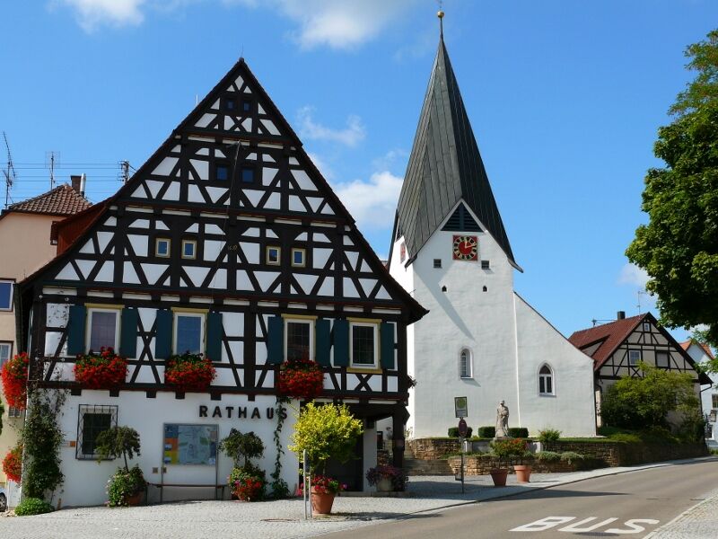
The picturesque, historic town hall in front of the church, located in the village center, was built in 1698 to serve as both a school and town hall—50 years after the Thirty Years’ War. It had a predecessor, a town hall that had apparently been severely damaged—perhaps even destroyed—during the Thirty Years’ War, and which, according to reports, was restored by Mayor Hans Bosch around 1652. In 2014, the town hall underwent a complete renovation.

Popularne wycieczki w okolicy
-
4,5
Lion Trail "Orchid Trail" - Herbs, pasqueflowers, and juniper heaths
średniWędrówka 9,33 km -
4,8
Löwenpfad "Filsursprung-Runde" - pure nature around the Reußenstein
średniWędrówka 14,1 km -
4,9
Lion Trail "Staufer Loop" — Following in Barbarossa's Footsteps Against a Dreamlike Backdrop
średniWędrówka 11,3 km -
5,0
Lion trail "Berta-Hörnle-Tour" - castle stories in a dreamlike setting
ciężkiWędrówka 14,7 km -
5,0
Boßler Round
średniWędrówka 8,61 km -
5,0
Owen - Teckberg - Brucker Hölzle - Hörnle
ciężkiWędrówka 13,1 km -
1,0
Nordalbrunde
średniWędrówka 4,76 km -
5,0
Lenningen: Weiße Lauter, Wasserfels, Guttenberger-,Gußmannshöhle, Schopflocher Moor, Hohgreutfels, Ruine Wielandstein
średniWędrówka 15,7 km -
5,0
Breitensteinrunde
światłoWędrówka 10,3 km -
4,5
Löwenpfad "Schloss-Filseck Loop" — Castle Tales and Lake Dreams
światłoWędrówka 3,97 km
Wędrówki i tropienie


Nie przegap ofert i inspiracji na następne wakacje
Twój adres e-mail została dodana do listy mailingowej.


