







Sources of the Lys

The hike starts at Staffal, a hamlet of Gressoney La Trinité, the last municipality in the valley of Gressoney or Lys valley. Take the trail on the left bank and, following the stream, head towards a white...
The hike starts at Staffal, a hamlet of Gressoney La Trinité, the last municipality in the valley of Gressoney or Lys valley. Take the trail on the left bank and, following the stream, head towards a white hut clearly visible already from the Staffal parking lot. The first part of the path is quite wide and flat, then it narrows and becomes steeper. After about 50 minutes of walking you reach the Courtlys alpine pasture. The trail continues in a larch forest before reaching the base of the moraine on the right side of which opens the Vallone della Salza, much appreciated in winter for off-piste skiing. Then you arrive at the crest of the moraine and, going left, you reach the sources of the Lys.
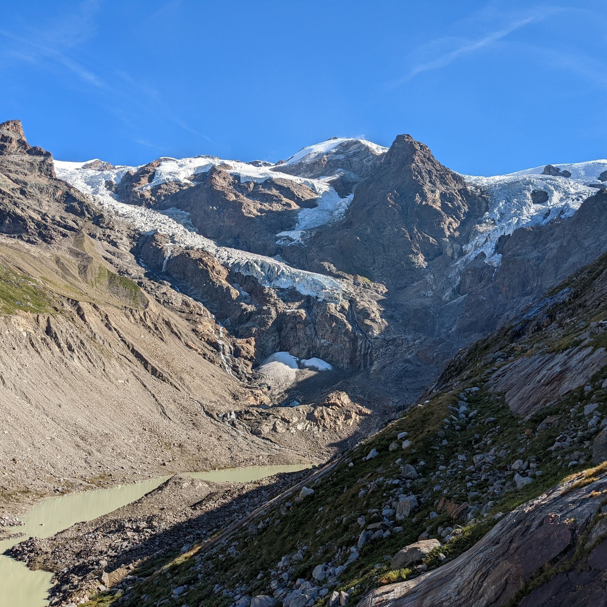

Leave the car in the hamlet of Staffal in Gressoney La Trinité; the trail starts on the right (left bank) of the bridge over the Lys, at the end of the valley; climb for a good stretch in a larch forest interspersed with wide clearings which are very flowery this season; rhododendron patches replace the trees; the trail moves away from the Lys and follows one of its side branches, until on the left appears the glacier moraine, which at the bottom is covered with rhododendrons and vegetation, and forms a small valley that can be walked on the comfortable trail on the right or on the top of the moraine itself. After the fork to Gnifetti, two slabs which can be easily passed, taking advantage of chains if necessary. The trail crosses a stream on a wooden footbridge, then starts to climb steeply reaching the moraine ridge; at the summit, when the terrain becomes less steep, a small trail marked with a white arrow leads to the sources, characterized by a beautiful turquoise pond, with emerging ice, at about 2400 m altitude. Those who want return to the trail and continue to follow the ridge or, when it has collapsed, move right, up to the end of the moraine, which reaches about 2700 meters in front of the impressive Lys and Felik icefall.
Tak
Tak
Hiking boots, snowshoes, backpack, waterproof jacket.
The initial route is very easy, but near the moraine you need to be careful, as it is a fairly steep section.
Turin-Aosta highway exit Pont S. Martin, S.S. 505 direction Gressoney.
Pass Gressoney-La Trinité, and arrive at Staffal.
Railway line connecting Milan and Turin to the Aosta Valley with a stop at Pont-Saint-Martin.
From the Pont-Saint-Martin station, take the Vita line bus towards Gressoney and get off at the last stop in the locality of Staffal in Gressoney La Trinité.
Large parking area in the locality of Staffal in Gressoney La Trinité.

Kamery internetowe z trasy
-
Punta Jolanda
-
Monte Rosa da Sitten
-
Punta Indren
-
Punta Indren
-
Punta Indren
-
Punta Indren
-
Punta Indren
-
Punta Indren
-
Punta Indren
-
Gabiet
-
Gabiet
-
Gabiet
-
Gabiet
-
Gabiet
-
Gabiet
-
Gabiet
-
Punta Grober
-
Piste Cimelagna und Bodwitch
-
Piste Cimelagna und Bodwitch
-
Piste Cimelagna und Bodwitch
-
Piste Cimelagna und Bodwitch
-
Salati Pass
-
Monte Rosa da Sitten
-
Monte Rosa da Sitten
-
Gressoney - La Trinité



Popularne wycieczki w okolicy
-
4,8
Klein Matterhorn - P3824 - Breithorn Occidentale / Westgipfel
średniWycieczka wysokogórska 5,53 km -
4,7
Quintino Sella al Felik 16 08 22
średniWędrówka 4,42 km -
5,0
Monte Rosa - Signalkuppe
średniWycieczka wysokogórska 12,7 km -
4,0
Riffelalp - Gornergrat
średniWędrówka 6,22 km -
4,7
Mont Roisetta
średniWędrówka 12,6 km -
5,0
Zermatt - Hirli - Schwarzsee paradise - Schwarzsee
średniTrasa tematyczna 6,40 km -
3,7
Rotenboden - Monte Rosa Hütte
ciężkiWędrówka 8,04 km -
Gnifetti hutte - pyramide vincent
światłoWędrówka 4,08 km -
Theodulhorn
światłoWędrówka 13,7 km -
4,7
Trail Running sulle 3 vette oltre i 3000m
ciężkiTrailrunning 16,7 km
Wędrówki i tropienie


Nie przegap ofert i inspiracji na następne wakacje
Twój adres e-mail została dodana do listy mailingowej.





