


Augusto Monti path


The Sentiero Augusto Monti is a literary thematic itinerary dedicated to the memory of the writer, who loved to spend the summer in the quiet Armirolo valley, in Cordria. It was established in 2006 to...
The Sentiero Augusto Monti is a literary thematic itinerary dedicated to the memory of the writer, who loved to spend the summer in the quiet Armirolo valley, in Cordria. It was established in 2006 to mark the 40th anniversary of his death. It is a panoramic circular itinerary that develops in the valley of the Romarolo torrent, in the municipal area of Giaveno, on the outskirts of the Turin area, and takes the hiker to discover suggestive panoramas and villages.

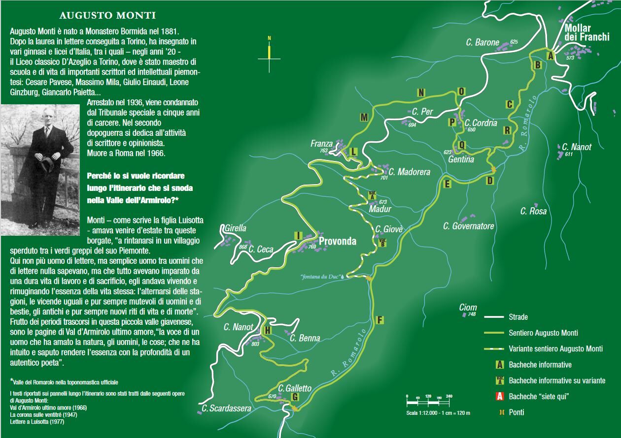
This is a ring-route that goes through the valley of the Romarolo stream, in the municipal territory of Giaveno. The Sentiero Augusto Monti is a literary themed itinerary dedicated to the memory of the writer, who loved to spend the summer in the quiet and secluded Armirolo valley, at Cordria. It was created in 2006 on the occasion of the 40th anniversary of his death. From the village of Mollar dei Franchi (579 m) you leave the carriage road that goes up from Giaveno at the end of a long straight road, to take the dirt road on the left that leads to the village of Gentina (623 m). When you reach a fountain and a bar, a short descent on the left leads to a bridge (Punt d'la Balueri) where you cross the Romarolo stream. From this point the itinerary winds for a long stretch on the hydrographic right of the stream as far as a characteristic stone bridge, after which you return to the left hydrographic side near Case Galletto (Can Galet, 670 m). The mule track now turns into a dirt track, which after several steep bends leads to Case Nanot (Can Nanot, 803 m), from which you continue to the right down the asphalt road to Provonda (769 m) with the beautiful parish church dedicated to St. Michael the Archangel, overlooking the valley. From here, follow the road downhill as far as the fork on the left that shortly leads to the lower cluster of Case Franza (La Fransa, 763 m) and continue along a path that, after passing a flat area of meadows and vegetable gardens, enters the woods and descends rapidly to Pian Siva. Following the signs, continue downhill through the woods to reach the road again that climbs for a very short stretch up to a signposted junction marked to the left that leads to the village of Cordria (650 m), where Augusto Monti stayed. From here you will soon reach the village of Gentina and going back along the first part of the itinerary you will reach the village of Mollar dei Franchi, ending the ring. If you wish, you can follow a variant that allows you to halve the length of the itinerary, excluding the upper part. In fact, by following the hydrographic right of the Romarolo stream, you will reach a concrete bridge that goes onto the hydrographic left on a steep dirt road that goes to the "du Duc" fountain and then the little villages of Madur (673 m) and Madorera (701 m), where you reach the asphalt road, which goes up to the left to Case Franza, connecting to the complete route.
Cemetery of Borgata Provonda with the ossuary in memory ofthe victims of the Round-up of 1944 and memorial tombstones on the Giaveno territory, the HistoricCentre The route dedicated to Francesco Gonin in the streets and squares of the Historic Centre
Popularne wycieczki w okolicy
Escursione Facile - Monte Cuneo (Moncuni) Itinerario ad anello da Reano
światłoWędrówka7,97 kmTOUR OF THE THREE REFUGEES -Amprimo - Toesca - Val Gravio
ciężkiWędrówka17 kmROLETTO Upslowtour - Foothills Loop 15
ciężkiJazda na rowerze30,0 kmPINASCA Ring of Grandubbione
średniJazda na rowerze28,8 kmSAN GERMANO CHISONE Lazzarà Hill Ring
ciężkiMountainbike29,6 kmPEROSA ARGENTINA Dahu Trail
ciężkiMountainbike44,2 kmThe Roads of the Forts - stage 2 from Pinerolo to Fenestrelle
ciężkiMountainbike44,7 kmThe Roads of the Forts - stage 5 from San Germano Chisone to Perosa Argentina
ciężkiWędrówka15,5 kmToward Canada
średniWędrówka15,2 kmPath of the Charcoal Piles Eco-museum
światłoWędrówka7,46 km
Wędrówki i tropienie


Nie przegap ofert i inspiracji na następne wakacje
Twój adres e-mail została dodana do listy mailingowej.