


Gröninger Feld circular path
Poziom trudności: T1


The 110 ha large "Gröninger Feld", located between Hameln and Holtensen, is framed by Bas- and Schweineberg as well as the Franzosenkopf.
From the Heisenküche forestry house, start southwest on the chestnut...
The 110 ha large "Gröninger Feld", located between Hameln and Holtensen, is framed by Bas- and Schweineberg as well as the Franzosenkopf.
From the Heisenküche forestry house, start southwest on the chestnut avenue. Then turn onto the Jakobsweg heading northwest and pass the Brüdersteine monument. Afterwards, continue north to the Landwehr and the Holtenser Warte.
You have completed about half of the route. Now follow the path east along the field and come across the Weserbergland trail, which you follow south until you return to your starting point. You have a refreshment opportunity at the "Heisenküche".
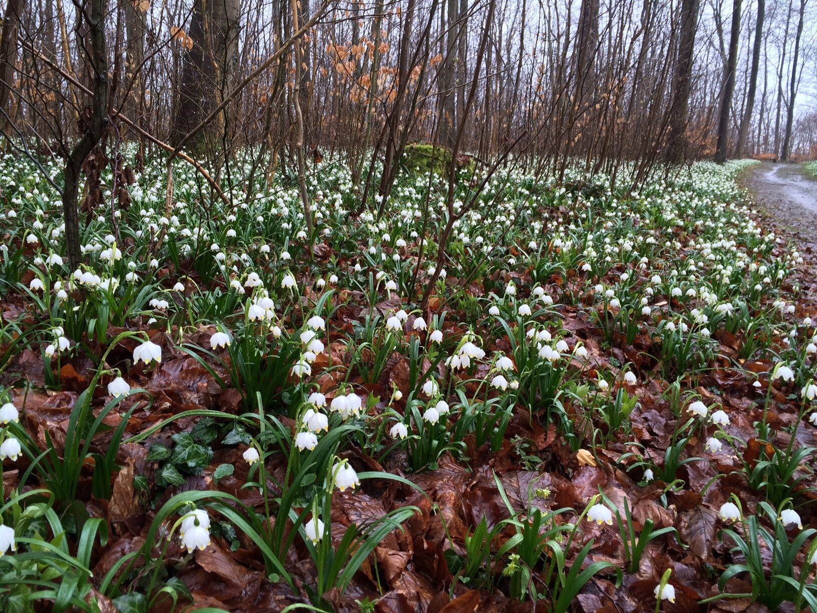
On your way, you hike over the Schweineberg, where Northern Germany's largest occurrence of the March snowflake is said to be located. The spring snowflake finds ideal conditions on shallow brown earth soils over Muschelkalk. You can also admire tree giants over 150 years old along your route.

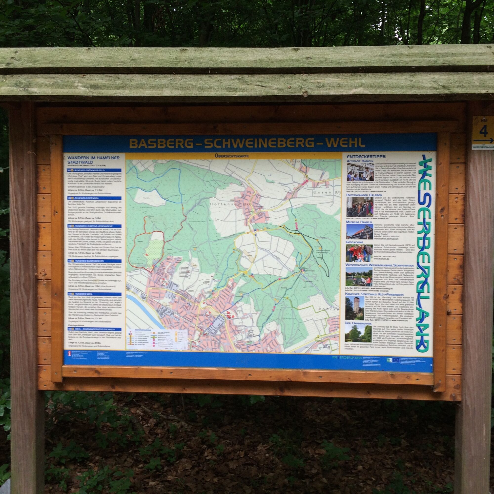
From the Heisenküche forestry house, start southwest on the chestnut avenue. Then turn onto the Jakobsweg heading northwest and pass the Brüdersteine monument. Afterwards, continue north to the Landwehr and the Holtenser Warte. Here you have completed about half the route. Now follow the path along the field eastward and finally come across the Weserbergland trail, which you follow south for a short distance until you arrive back at your starting point.
The path surface consists of 30% gravel and 70% natural trails.
No special equipment necessary.
The path is not suitable for wheelchair users and prams.
The European transport hub Hanover lies about 50 km from Hameln by federal road and rail. The town of Hameln is the intersection of federal roads B 1, B 83, and B 217. The network of federal roads radiating from the center of Hameln is further densified by state and district roads. The distance to the nearest motorway exit is about 20 km to the A 2 (Ruhr area-Hanover-Berlin), about 45 km to the A 7 (Hamburg-Hanover-Kassel).
Hameln train station: regular connections S5 (Hanover Airport - Paderborn), RB 77 of the Nordwestbahn (Hildesheim - Bünde)
City Pfortmühle bus stop: regular connection to Hameln city transport and regional bus lines (Hope, Hemeringen, Hessisch Oldendorf, Bad Pyrmont, Grießem, Groß Berkel, Klein Berkel)
Use the parking lot at the Heisenküche forestry house.
T1
http://www.weserbergland-tourismus.de/
Walk near the "Heisenküche" guesthouses on a forest nature trail and help yourself to the chestnuts.
In spring, be sure to admire the March snowflake bloom.
Popularne wycieczki w okolicy
Three-Castle Route (RI5)
średniWędrówka13,6 kmThrough the lovely Walterbachtal
średniWędrówka8,55 km- 5,0
Hohenstein - ein Nachmittagsspaziergang
światłoWędrówka8,40 km - 3,7
Süntel-Hamelspringe-Süntelturmrunde
światłoWędrówka9,42 km Weserbergland-Weg, 11. Etappe: Hameln bis Rohdental
światłodługodystansowy szlak pieszy27,2 kmMegamarsch Weserbergland 2023
ciężkiWędrówka100,5 km- 4,0
Kreuzstein-Route
średniWędrówka7,43 km Megamarsch Weserbergland 2022
ciężkiWędrówka100,1 kmWalterbachtal im Deister, Eimbeckhauser Panoramaweg
światłoWędrówka12,5 km- 5,0
Großer Rundwanderweg Aerzen
ciężkiWędrówka44,5 km
Wędrówki i tropienie


Nie przegap ofert i inspiracji na następne wakacje
Twój adres e-mail została dodana do listy mailingowej.