


To the Spat Gorge
Gorges, Pits and Shafts
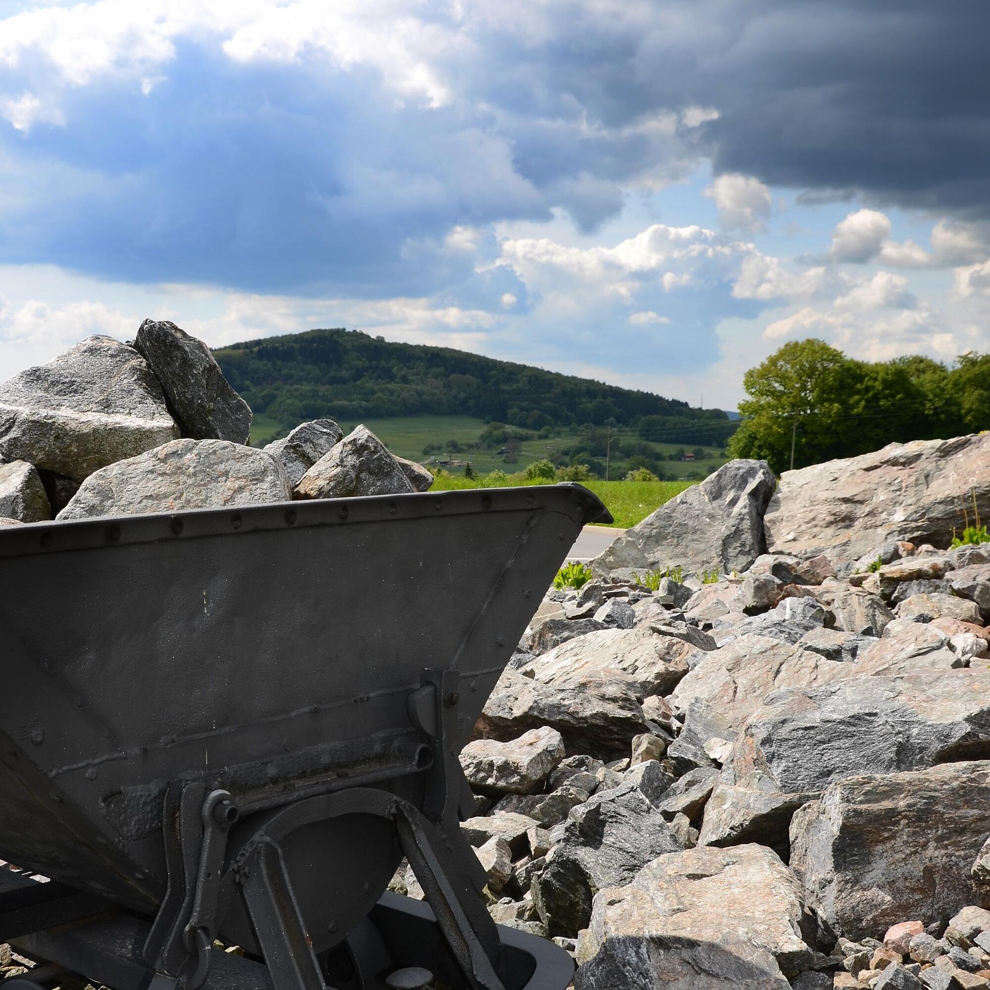
From the Pappelbach Valley over the ridge of the "Obere Griet" to the "Weittal" you can see the traces of wolfram mining strung together like a string of pearls. The surface collapses,...
Gorges, Pits and Shafts
From the Pappelbach Valley over the ridge of the "Obere Griet" to the "Weittal" you can see the traces of wolfram mining strung together like a string of pearls. The surface collapses, known as pits, and exploration trenches clearly show the aboveground and underground mining. Initially, open-cast mining was carried out before switching to underground mining. The extracted wolfram was shipped to the Netherlands, where it was used in paint production. In 1939, wolfram mining in Schriesheim was discontinued because all the wolfram had been extracted.
In the Hermannsgrund, feldspar was mined in an open-cast mine. Particularly pure rock material was needed in Frankenthal and Mannheim for porcelain production. Less pure material was used for ceramic glazes. Mining was also stopped here in 1939.
From the parking lot we follow the OWK marking II (yellow) first through the vineyards, then up the forest. Above the Schriesheimer Hut (served on Sat/Sun) we reach the geological nature trail "L" of Schriesheim. Steinberg (km 4.0; time 1:30; elevation 410 m)
Then we follow it to the right into an old mining area where large amounts of wolfram and feldspar have been mined since the early 19th century. Obere Griet (km 1.8; time 0:30; elevation 330 m)
Collapses and deep exploration trenches are unmistakable witnesses of the former mining. The hike leads along the edge of the trench over the "Obere Griet" to the field "Lange Schar". From here we proceed to Martinsbach and from there on to the Spat Gorge. Spat Gorge (km 1.1; time 0:20; elevation 270 m)
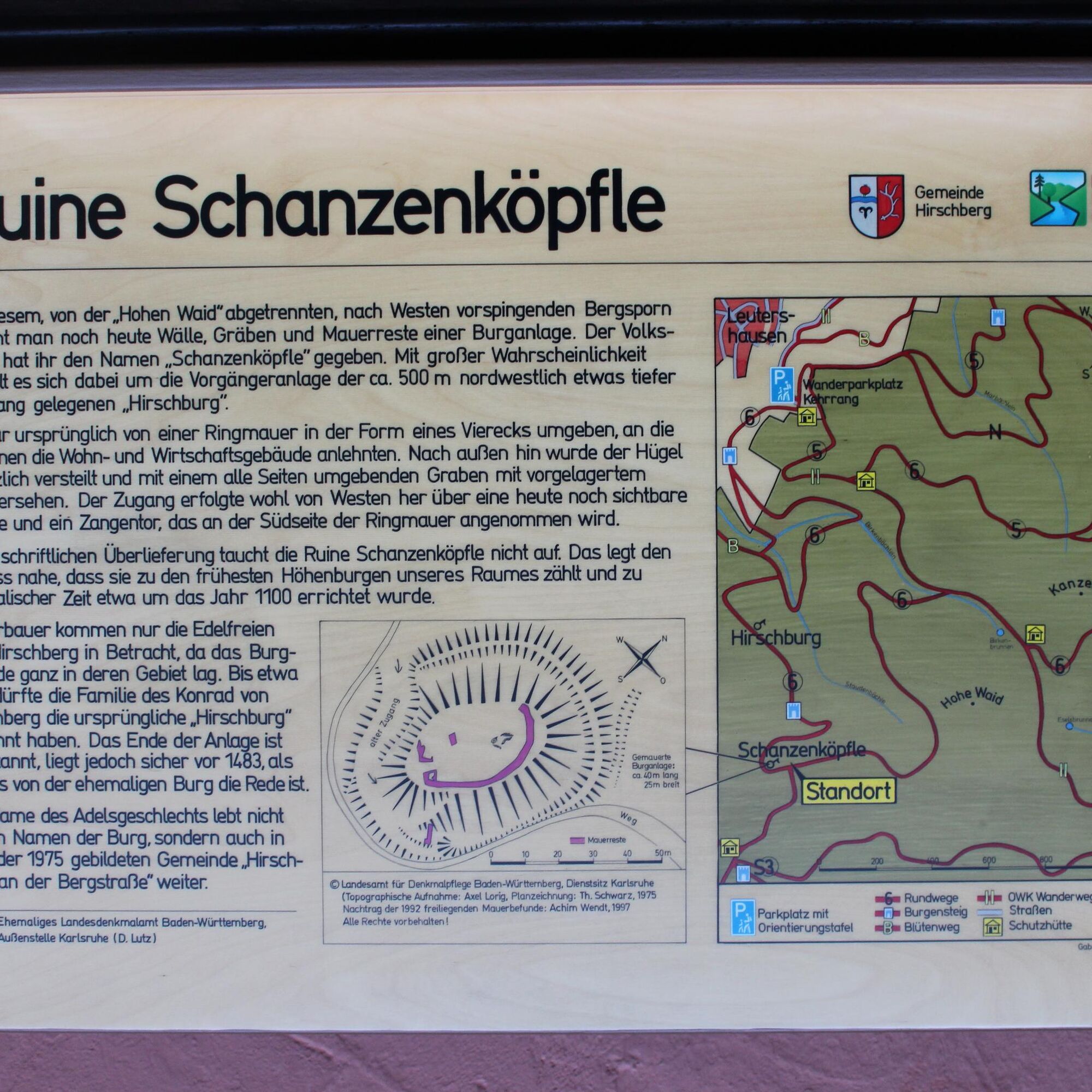
The Spat Gorge has been a natural monument since 1937. It was formed by open-cast mining. The nature trail leads right through the gorge into the Hermannsgrund. Above Hermannsgrund we leave the nature trail and follow the Burgensteig Bergstraße (blue castle symbol) to Schanzenköpfle. Schanzenköpfle (km 2.9; time 1:05; elevation 400 m)
The earthen mound and the ring trench show the former fortification. On the summit, individual wall remains are still present. Our trail leads around Schanzenköpfle on a narrow forest path steeply downhill to Hirschburg. Hirschburg (km 0.7; time 0:15; elevation 307 m)
Only a few remains of this castle are left. From the ruins, a massive vault stands out, presumably parts of the former keep. From the castle we follow the Burgensteig Bergstraße first through the forest and then through the vineyards back to our starting point. Kehrrang Parking Lot (km 1.2; time 0:20; elevation 220 m)
Tak
The start and end point "Kehrrang" is a hiking parking lot.
Popularne wycieczki w okolicy
- 4,7
Wilhelmsfeld: hike through the Kameralwald
średniWędrówka 10,0 km - 4,7
Zum Königstuhl
średniWędrówka 15,9 km - 5,0
Vier-Burgen-Tour Neckargemünd/Neckarsteinach
Wędrówka 12,8 km - 4,0
Neckarsteinach, 4-Burgen-Blick
średniWędrówka 16,3 km - 4,7
Weinheim - Bocksberg-Weg
średniWędrówka 6,88 km - 4,0
Neckarsteig Etappe 1 + 2
średniWędrówka 23,1 km Burgensteig Bergstraße (komplette Route)
Wędrówka 116,2 km- 3,5
Rundweg: Aschbach-Raubach-Frankel-Säckenrain-Grube
światłoWędrówka 20,6 km Hike to the pilgrimage site Kreuzberg
ciężkiWędrówka 18,1 kmSchriesheim Klettersteig, Germany
światłoVia ferrata 3,78 km

Wędrówki i tropienie


Nie przegap ofert i inspiracji na następne wakacje
Twój adres e-mail została dodana do listy mailingowej.