© Valais/Wallis Promotion - Olivier Maire


- Krótki opis
-
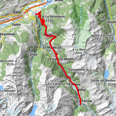
This climb in the heart of the central Valais from Sierre to the Mayen de Colombire will take you first on a journey to discover the sunny slopes of the right bank of the Rhone before heading up towards Aminona then the Col de Crans-Montana where a panoramic view will take your breath away.
- Stopień trudności
-
ciężkie
- Ocena
-
- Trasa
-
Siders (533 m)0,0 kmRionda1,9 kmVeyras (645 m)3,0 kmVenthen (799 m)5,0 kmConzor7,0 kmSaint-Maurice-de-Laques7,9 kmLa mi-côte8,4 kmMollens (1.070 m)8,5 kmAminona12,8 kmMayen de la Cure14,0 km
- Najlepszy sezon
-
stylutmarkwimajczelipsiewrzpaźlisgru
- Najwyższy punkt
- 1.801 m
- Miejsce docelowe
-
Col de Crans-Montana
- Profil wysokości
-
 © outdooractive.com

- Autor
-
Wycieczka Col de l'Aprilly – Legendary Mountain Passes jest używany przez outdooractive.com pod warunkiem.
GPS Downloads


Informacje ogólne
Przystanek odświeżania
Flora
Obiecujący
Więcej wycieczek w regionach
-
Thyon les Collons
118
-
Crans - Montana
89
-
Noble-Contrée
38