
- Krótki opis
-
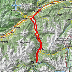
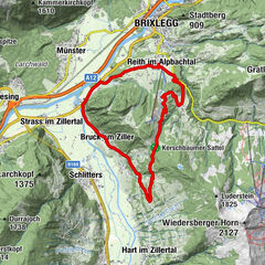
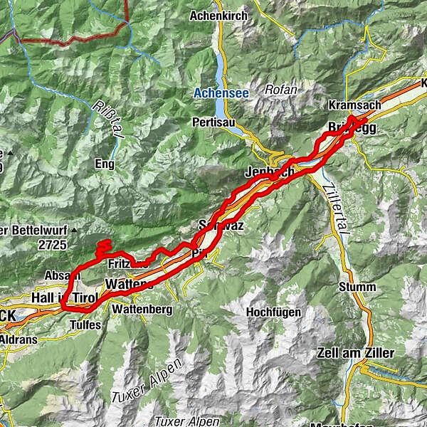
This is a more sportive variant of the "15 Oberes Inntal" tour, avoiding busy main roads leading through small villages to the left and right of the Inn Valley. The climb to the Hinterhorn Alm is only for the hardened cyclist. Omit for an easier ride.
- Stopień trudności
-
ciężkie
- Ocena
-
- Trasa
-
Rattenberg0,0 kmAmerling1,4 kmKramsach1,6 kmBrixlegg2,5 kmHagau (517 m)2,5 kmPizzeria Buongiorno5,5 kmMünster (535 m)6,3 kmEntgasse6,7 kmHaus7,6 kmBradl8,5 kmBus-Stop9,6 kmDorfwirt9,9 kmWiesing9,9 kmPfarrkirche Heiliger Wolfgang und Leonhard13,3 kmJenbach (563 m)13,4 kmHupfaufkapelle14,4 kmTratzberg16,0 kmFriedhofskapelle18,8 kmGasthof Marschall18,9 kmStans18,9 kmSchwaz21,7 kmVomp23,0 kmGasthaus Pelikan23,1 kmVomperbach25,3 kmTerfens27,9 kmWallfahrtskirche Maria-Larch29,0 kmWasserkapelle Maria Larch29,1 kmErscheinungskapelle Maria Larch29,1 kmEggen30,3 kmInnerwald33,6 kmKranzach34,2 kmSt. Michael35,2 kmGnadenwald (879 m)35,7 kmSpeckbacherkapelle36,0 kmAußerwald36,1 kmSt. Martin36,6 kmMartlboden41,2 kmHinterhorn Alm43,0 kmWalderkapelle51,1 kmNepomukkapelle51,9 kmSchmankerlstock52,4 kmPfarrkirche Eichat52,6 kmLa Taverna53,5 kmKaiser Franz Josef-Gedächtniskapelle54,6 kmHall in Tirol (574 m)55,0 kmBorgiaskapelle58,1 kmVolderwald (558 m)58,4 kmMühlinger58,7 kmKarlskirche60,2 kmVolders (558 m)61,2 kmCafe Bräu61,3 kmPfarrkirche hl. Johannes dem Täufer61,3 kmPizzeria Del Sole61,8 kmKreuzbichl62,7 kmWattens (564 m)63,4 kmLaurentiuskirche Wattens63,6 kmFriedhofskapelle63,6 kmEvang. Christuskirche63,8 kmSwarovski Fountain63,9 kmKolsass (553 m)66,8 kmWeer67,2 kmPfarrkirche Sankt Gallus67,5 kmPfarrkirche Heilige Anna71,0 kmPill (556 m)71,0 kmKreuzkirchl72,1 kmSchwaz74,4 kmATIB Schwaz74,9 kmKnappenkuchl76,8 kmKreuzkapelle76,8 kmEdenhofkapelle77,5 kmBuch in Tirol79,8 kmBauernkuchl81,5 kmJenbach (563 m)82,0 kmMaurach82,6 kmGasthof Esterhammer83,7 kmStrass im Zillertal (525 m)85,6 kmPfarrkirche Strass85,8 kmPfarrkirche zum Heiligen Jakobus d. Ä85,9 kmStrass im Zillertal (523 m)85,9 kmSankt Gertraudi (527 m)88,6 kmFilialkirche St. Gertraudi88,7 kmLichtwerth (529 m)89,8 kmRestaurant Gut Matzen90,4 kmWeng (526 m)91,2 kmBrixlegg91,9 kmRattenberg93,8 km
- Najlepszy sezon
-
stylutmarkwimajczelipsiewrzpaźlisgru
- Najwyższy punkt
- 1.524 m
- Miejsce docelowe
-
Rattenberg, town main square fountain
- Profil wysokości
-

-

-
AutorWycieczka Road bike 14 Hinterhorn Alm jest używany przez outdooractive.com pod warunkiem.
GPS Downloads


Informacje ogólne
Przystanek odświeżania
Obiecujący
Więcej wycieczek w regionach
-
Silberregion Karwendel
43
-
Vomp
17