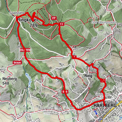
Hartberg - Eggendorf - Lungitz - Lafnitztal (Maierhofermühle)

Wędrówka

- Krótki opis
-
An approx. 10 kilometre hike from Hartberg to Eggendorf, Unterlungitz to the Lafnitztal valley to the Maierhofermühle mill with the option of returning to Hartberg by bus. (Please note the timetable and opening hours of the restaurants along the route. They are closed on Mondays and Tuesdays).
- Stopień trudności
-
łatwe
- Ocena
-
- Trasa
-
HartbergGasthaus Eggendorfwirt3,4 kmEggendorf3,4 kmUnterlungitz5,1 kmGasthaus Maierhofer-Mühle8,1 km
- Najlepszy sezon
-
stylutmarkwimajczelipsiewrzpaźlisgru
- Najwyższy punkt
- 427 m
- Miejsce docelowe
-
Hartberg, bus station
- Profil wysokości
-

- Autor
-
Wycieczka Hartberg - Eggendorf - Lungitz - Lafnitztal (Maierhofermühle) jest używany przez outdooractive.com pod warunkiem.
GPS Downloads


Informacje ogólne
Przystanek odświeżania
Kulturalny/Historyczny
Flora
Więcej wycieczek w regionach
-
Thermen- & Vulkanland
1323
-
Hartbergerland
826
-
St. Johann in der Haide
139