© © Waldviertel Tourismus, Erwin Haiden, nyx.at - Destination Waldviertel

- Krótki opis
-
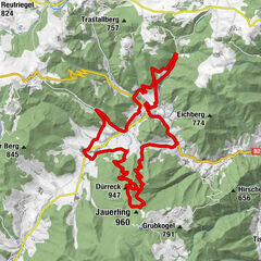
Kottes - Felles - Teichmanns - Purk - Voitsau - Kottes
- Stopień trudności
-
średni
- Ocena
-
- Trasa
-
KottesHubertuskapelle1,1 kmMünichreith2,3 kmKogel5,5 kmRichterhof5,5 kmFelles6,3 kmGemeindefeld7,1 kmErnst7,4 kmTeichmanns11,2 kmGotthardschlag13,1 kmDorfwirtshaus16,9 kmPurk17,1 kmPfarrkirche Hl. Martin17,1 kmDankholz19,2 kmHirtbüchel20,2 kmVoitsau20,4 kmKellergrabenäcker21,1 kmKottes22,2 kmPfarrkirche Maria Berg im Tal22,4 km
- Najlepszy sezon
-
stylutmarkwimajczelipsiewrzpaźlisgru
- Najwyższy punkt
- 860 m
- Miejsce docelowe
-
Kottes
- Profil wysokości
-

- Autor
-
Wycieczka Maria Berg im Tal-Strecke jest używany przez outdooractive.com pod warunkiem.
GPS Downloads


Więcej wycieczek w regionach
-
Donau Niederösterreich
151
-
Waldviertel Mitte
101
-
Kottes-Purk
32