
- Krótki opis
-
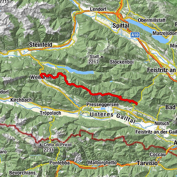
The entire trail is a magnificent but very long high-level hike over the Gailtal Alps, with magnificent views of the Gailtal and Weissensee, the Carnic and Julian Alps.
- Stopień trudności
-
średni
- Ocena
-
- Trasa
-
WeißbriachMosmüller1,1 kmMemmeralpl3,8 kmGföllnock (1.502 m)4,0 kmMittagsnock (1.473 m)5,2 kmNaggler Alm8,4 kmGeißrücken10,9 kmJadersdorfer Ochsenalm11,9 kmKohlröslhütte12,4 kmSattelköpfe (1.684 m)14,3 kmGolz (2.004 m)15,4 kmRadniger Sattel (1.554 m)16,6 kmSpitzegel (2.119 m)20,1 kmKriebhöhe (2.065 m)21,5 kmVellacher Egel (2.108 m)22,1 kmVellacher Sattel (1.858 m)23,3 kmGraslitzen (2.044 m)25,3 kmGraslitzen Ostgipfel (1.932 m)26,7 kmGeorgikapelle29,4 kmSussawitscher Sattel (1.418 m)30,2 km
- Najlepszy sezon
-
stylutmarkwimajczelipsiewrzpaźlisgru
- Najwyższy punkt
- 2.079 m
- Miejsce docelowe
-
Windische Höhe
- Profil wysokości
-


- Autor
-
Wycieczka Gailtaler Höhenweg, Abschnitt Weißbriach-Windische Höhe jest używany przez outdooractive.com pod warunkiem.
GPS Downloads


Informacje ogólne
Obiecujący
Więcej wycieczek w regionach