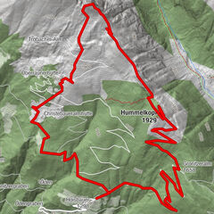
Dane wycieczki
10,75km
784
- 1.581m
750hm
750hm
04:00h
- Krótki opis
-
Von Weißbriach geht's den Waisacheralmweg Nr. 10 bis zur Pfarreben. Hier biegt man links auf die Forststraße Nr. 11 ab und gelangt so zur Comptonhütte (Jausenstation). Der Weg ist von Ruinen geprägt die von der glorreichen, industriellen Vergangenheit sowie dem Bergbau in diesem Gebiet erzählen.
- Stopień trudności
-
średni
- Ocena
-
- Punkt wyjścia
-
Gemeindeamt Weißbriach
- Trasa
-
Weißbriach0,2 kmLengauer-Brünndl2,6 kmKneippquelle / Ruinen-Brünndl3,6 kmE.T.-Compton-Hütte (1.585 m)10,7 km
- Najlepszy sezon
-
stylutmarkwimajczelipsiewrzpaźlisgru
- Najwyższy punkt
- 1.581 m
- Miejsce docelowe
-
E.T. Comptonhütte
- Odpoczynek/Odosobnienie
-
Waisacher Alm, E.T. Comptonhütte
- Mapy
-
Freizeit-Erlebnis Karte Gitschtal; WK223 Naturarena Kärnten
- Źródło
- Tourismusbüro Gitschtal
GPS Downloads


Warunki na szlaku
Asfalt
Żwir
Łąka
Las
Skała
Wyeksponowany
Więcej wycieczek w regionach