© Kempten Tourismus - Tourist Information Kempten


© Outdooractive Redaktion - Albert Rinn
Dane wycieczki
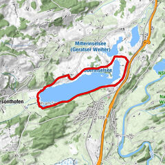
11,14km
648
- 715m
54hm
41hm
03:15h

- Krótki opis
-
Abwechslungsreicher Rundweg entlang der Iller und durch den landwirtschaftlich geprägten Norden Kemptens.
- Stopień trudności
-
łatwe
- Ocena
-
- Trasa
-
Hirschdorf0,3 kmSchlatt0,9 kmWies3,1 kmBezachmühle3,5 kmEllatsberg4,0 kmReisachmühle5,0 kmUnterer Wirt5,9 kmHeiligkreuz6,0 kmNeuhausen6,8 kmKempten (Algovia) (674 m)7,6 kmStiftsbleiche7,9 kmHärtnagel8,1 kmZollhaus9,0 kmHirschdorf10,9 km
- Najlepszy sezon
-
stylutmarkwimajczelipsiewrzpaźlisgru
- Najwyższy punkt
- 715 m
- Miejsce docelowe
-
Parkplatz am Iller-Denkmal
- Profil wysokości
-
 © outdooractive.com


- Autor
-
Wycieczka Kempten Wandertour: Rund um Hirschdorf jest używany przez outdooractive.com pod warunkiem.
GPS Downloads


Więcej wycieczek w regionach
-
Allgäu
2357
-
Oberallgäu
1584
-
Lauben
127