Mindelheimer Klettersteig - Etappentour - Allgäuer Picknickplätze

Wędrówka

© Meckatzer Löwenbräu Benedikt Weiß KG - Silke Teltscher

- Krótki opis
-
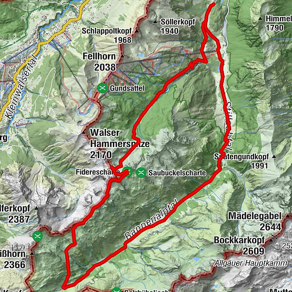
Anspruchsvolle Etappen-Wanderung von Schwand über die Fiderepasshütte zur Mindelheimer Hütte und durch das stille Rappenalpental zurück.
- Stopień trudności
-
średni
- Ocena
-
- Trasa
-
Ringang0,5 kmGasthof Laiter1,2 kmFiderepasshütte8,4 kmMittlerer Schafalpkopf (2.302 m)10,3 kmKemptner Kopf (2.193 m)11,9 kmMindelheimer Hütte12,7 kmAlpe Eschbach24,1 kmBirgsau24,5 kmAnatswald25,3 kmFellhornbahn I26,7 kmFellhornbahn II (918 m)26,7 kmFellhornstuben26,8 kmRingang28,3 km
- Najwyższy punkt
- 2.289 m
- Miejsce docelowe
-
Mindelheimer Klettersteig
- Profil wysokości
-
 © outdooractive.com

- Autor
-
Wycieczka Mindelheimer Klettersteig - Etappentour - Allgäuer Picknickplätze jest używany przez outdooractive.com pod warunkiem.
GPS Downloads


Informacje ogólne
Przystanek odświeżania
Obiecujący
Więcej wycieczek w regionach